When is the First Snowfall in Iowa? Average Dates by City
As autumn gives way to winter, one of the most common questions Iowans ask is, When will the first snow arrive? While it is not unusual for a surprise snow event to occur in late October, the first official snowfall usually doesn’t arrive until November. The technical definition for the first snowfall is an accumulation of at least one inch or more. Flurries or trace amounts may fall earlier in the season, but meteorologists don’t count those as the true start of winter.

Average First Snowfall Dates by City in Iowa
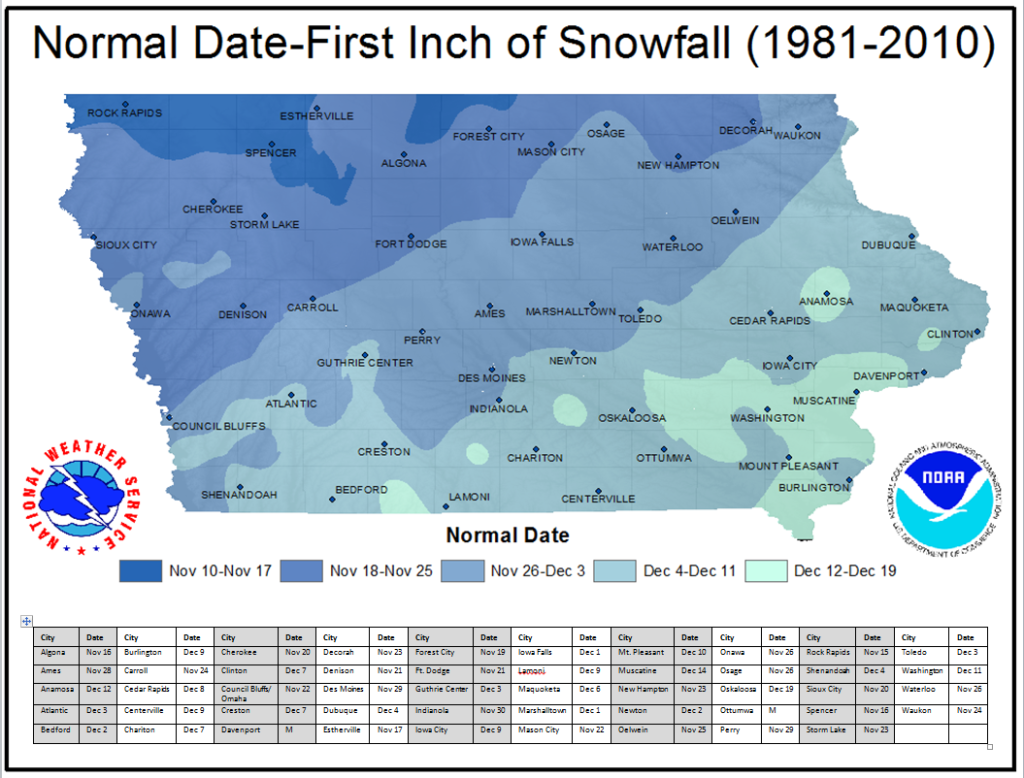
Based on historical averages, here’s when the first snowfall usually occurs in major Iowa cities:
- Algona: Around November 16
- Ames: Around November 28
- Anamosa: Around December 12
- Atlantic: Around December 3
- Bedford: Around December 2
- Burlington: Around December 9
- Carroll: Around November 24
- Cedar Rapids: Around December 8
- Centerville: Around December 9
- Chariton: Around December 7
- Cherokee: Around November 20
- Clinton: Around December 7
- Council Bluffs: Around November 22
- Creston: Around December 7
- Davenport: Around November 19
- Decorah: Around November 23
- Denison: Around November 21
- Des Moines: Around November 29
- Dubuque: Around December 4
- Estherville: Around November 17
- Forest City: Around November 19
- Fort Dodge: Around November 21
- Guthrie Center: Around December 3
- Indianola: Around November 30
- Iowa City: Around December 9
- Iowa Falls: Around December 1
- Lamoni: Around December 9
- Maquoketa: Around December 6
- Marshalltown: Around December 1
- Mason City: Around November 22
- Mt. Pleasant: Around December 10
- Muscatine: Around December 14
- New Hampton: Around November 23
- Newton: Around December 2
- Oelwein: Around November 25
- Onawa: Around November 26
- Osage: Around November 26
- Oskaloosa: Around December 19
- Ottumwa: Around November 21
- Perry: Around November 29
- Rock Rapids: Around November 15
- Shenandoah: Around December 4
- Sioux City: Around November 20
- Spencer: Around November 16
- Storm Lake: Around November 25
- Toledo: Around December 3
- Washington: Around December 11
- Waterloo: Around November 26
- Waukon: Around November 24
Note: These dates represent averages. In some years, snow arrives weeks earlier or later depending on storm tracks, ground temperatures, and seasonal weather patterns.
Why the First Snowfall Varies
These differences in snowfall timing are tied to a few key factors. Geography plays an important role, as northwestern Iowa sits closer to colder air masses and storm tracks that sweep down from the Dakotas and Minnesota, which brings snow earlier in the season. Southeastern Iowa is usually influenced by milder air that delays snow accumulation until later in November or even December.
Ground temperatures also matter—early in the season, the soil often remains above freezing, which means that even if snowflakes fall, much of the accumulation will melt before sticking. Seasonal climate patterns such as El Niño or La Niña can also cause noticeable shifts, sometimes pushing the first snow weeks earlier or later than normal. A good example of this variation occurred in 2019, when many Iowans saw their first snow on Halloween.
Earliest and Latest First Snowfall in Iowa
Looking back at historical records, the earliest snowfall ever observed in Iowa occurred on September 16, 1881, in the northwest part of the state. On the other end of the spectrum, southeastern Iowa sometimes does not see its first measurable snowfall until mid- to late December. Overall, the window for Iowa’s first snow stretches from late October to mid-December, depending on location and year-to-year weather patterns.
How much snow does Iowa receive in a season?
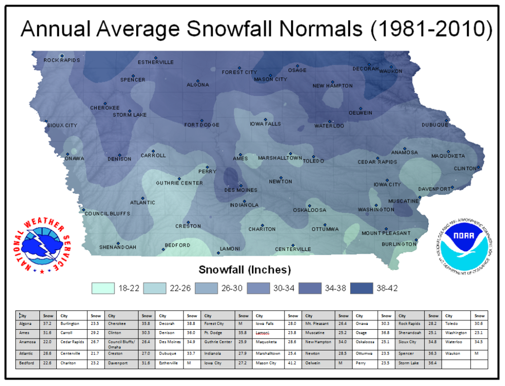
Seasonal snowfall totals also vary significantly across the state. In southern Iowa, the average snowfall ranges from 18 to 22 inches for the season, while in northern Iowa, totals are much higher, averaging between 38 and 42 inches. These differences reflect the same geographic and climatic influences that affect the timing of the first snowfall.

Looking Ahead
For the 2025 season, the Farmer’s Almanac predicts Iowa’s first widespread snow will arrive mid-to-late November, which lines up well with long-term averages.
As winter approaches, stay tuned to the Iowa Storm Chasing Network (ISCN) for the latest snowfall forecasts. Follow us on Facebook, Twitter, or download our free ISCN Weather App for real-time updates tailored to your city.