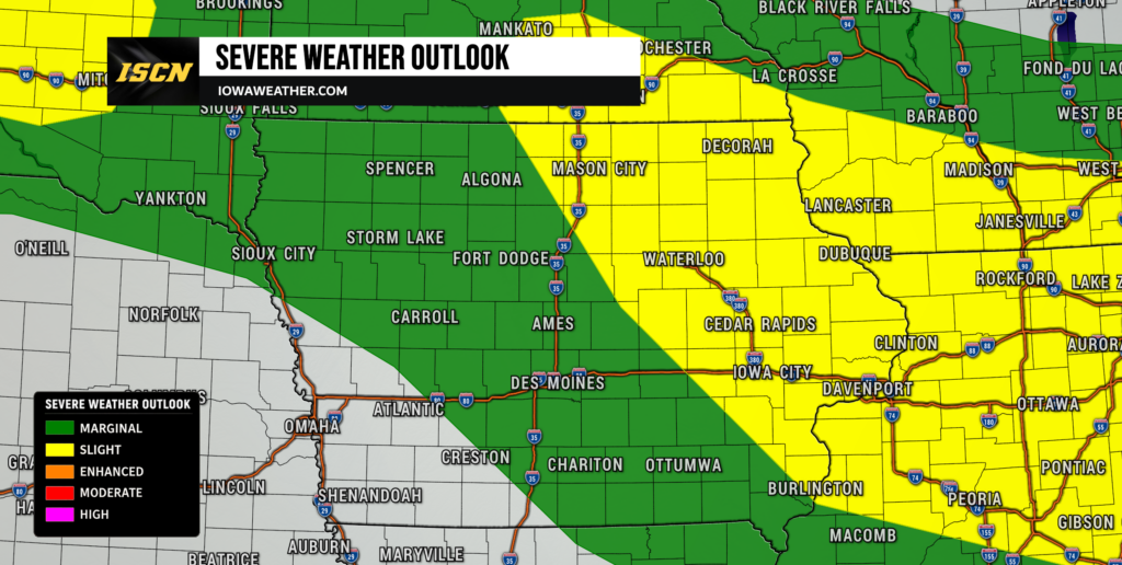
Iowa is starting Sunday with thunderstorms, and some could bring large hail, damaging winds and locally heavy rainfall before moving east later this morning. Another cluster moving southeast from Minnesota could pose a greater damaging wind threat across northern and eastern Iowa before midday. Exactly where the strongest storms travel remains uncertain because the overnight and morning activity has developed differently than many short-range weather models anticipated.
Behind the storms, Sunday turns warm and very humid. Heat index values could approach 100 degrees across southern Iowa and reach 100 to 105 in portions of southeastern Iowa where a Heat Advisory is in effect. The bigger weather story extends well beyond today, however, as a stalled boundary keeps Iowa in an active pattern with additional thunderstorm chances throughout the upcoming week.
Sunday: Morning Storms, Then Hot and Humid
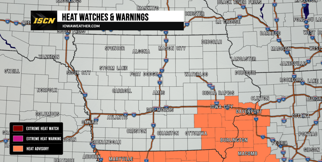
Thunderstorms will continue moving through portions of Iowa Sunday morning, with northern, central and eastern Iowa seeing some of the better chances for rain. Large hail is possible with stronger individual storms, while a more organized cluster moving into northern and eastern Iowa could produce damaging wind gusts. Torrential rainfall is another concern, with some storms capable of producing 1 to 2 inches of rain per hour and localized flash flooding where the heaviest rain crosses urban areas. Most morning storms should move away or weaken by around midday, although additional development later Sunday or Sunday night cannot be ruled out. Highs should range from the lower 80s north to around 90 or slightly warmer south, with heat index values near 100 degrees across southern Iowa. Wildfire smoke will also remain overhead and could produce hazy skies while slightly limiting afternoon heating.
Severe Weather Risk Favors Wind and Hail
The primary severe weather threats Sunday are damaging winds and large hail, with the more organized risk focused across eastern Iowa into northern Illinois and southern Wisconsin. Storms moving through northern and eastern Iowa this morning could organize into a faster-moving complex capable of producing damaging wind gusts. Additional severe storms later in the day would depend heavily on how quickly the atmosphere recovers from the morning rainfall and cloud cover. Areas receiving several hours of sunshine could become quite unstable, while locations remaining cloudy would have a lower severe weather risk. A tornado cannot be completely ruled out near localized storm boundaries, but the overall tornado threat is lower than the damaging wind and hail threats. Forecast confidence is therefore higher that some strong storms will occur in the region than it is in exactly which Iowa communities will experience them.
Heavy Rain Becomes Increasingly Important
Heavy rainfall could become a bigger part of Iowa’s weather story as repeated thunderstorms move through the region this week. Sunday’s storms are capable of producing intense rainfall over short periods, but widespread flooding is not currently expected. The concern increases if the same communities receive additional storms Monday, Tuesday and again during the middle of the week. Moisture will remain abundant, allowing thunderstorms to produce substantial rainfall efficiently whenever they develop. Wednesday into Thursday currently appears particularly important, with a stronger signal for organized thunderstorms and excessive rainfall somewhere across the Corn Belt. The exact heaviest-rain corridor remains uncertain, but southeastern Iowa and areas near the Iowa-Missouri-Illinois border will be worth watching closely by Thursday.
Iowa Weather This Week: Day-by-Day Forecast
Monday: Hot, Humid With More Storm Chances
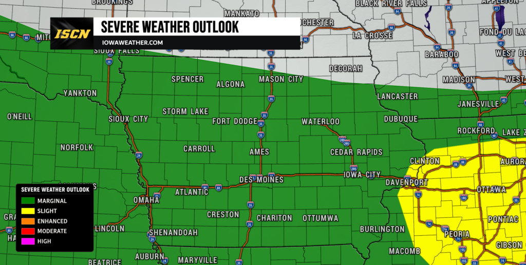
Monday will remain warm and humid, with highs generally in the 80s and some locations potentially reaching the lower 90s. A few thunderstorms could be around early in the day depending on how Sunday night’s activity evolves. Additional isolated thunderstorms could develop later Monday as another weak disturbance moves through the region. Any stronger storms would be capable of hail, damaging wind gusts and locally heavy rain. Thunderstorm coverage remains uncertain, meaning some areas could receive another soaking while others remain dry for most of the day. Humidity will remain noticeable even where storms do not develop.
Tuesday: Scattered Storms Remain Possible

Tuesday brings another chance for scattered thunderstorms as Iowa remains beneath west-to-northwest flow aloft. The atmosphere could become quite unstable during the afternoon, providing plenty of energy for any thunderstorms that manage to develop. Severe wind gusts and hail would be the primary hazards with stronger storms. The limiting factor may be a lack of a strong trigger, which means thunderstorm coverage could remain relatively isolated. Temperatures should generally remain seasonable to warm, with many locations in the 80s. Confidence in exact storm timing and placement is relatively low because Monday’s thunderstorms will help determine where boundaries are positioned Tuesday.
Wednesday: Storm Chances Increase
Thunderstorm chances may become more widespread Wednesday as another disturbance approaches the region and interacts with the stalled frontal boundary. Moisture will remain plentiful, increasing the potential for thunderstorms to produce heavy rainfall. Some storms could also become severe where sufficient instability develops, with damaging winds and hail remaining the primary concerns. The greatest storm coverage may not arrive until Wednesday evening or Wednesday night, although timing will continue to be refined. Repeated thunderstorms could begin increasing the localized flooding risk, particularly in areas that receive substantial rain earlier in the week. Temperatures should trend closer to seasonal averages as clouds and rain become more widespread.
Thursday: Heavy Rain Potential Bears Watching
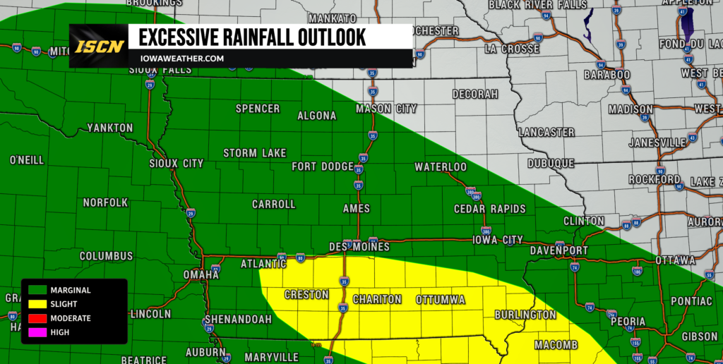
Thursday currently stands out as one of the more important days to watch for thunderstorms and heavy rainfall across the region. A frontal boundary should remain near Iowa while very moist air feeds into thunderstorms developing from eastern Nebraska through Iowa and toward Illinois. Repeated storms could produce locally significant rainfall, especially across southeastern Iowa and near the Iowa-Missouri-Illinois border. Severe weather will also remain possible, although the exact threat will depend heavily on where overnight storms leave boundaries and pockets of instability. Cloud cover and rain should begin holding temperatures down compared with the hotter start to the week. Confidence is increasing that thunderstorms will remain part of Thursday’s forecast, but the location of the heaviest rain remains uncertain.
Friday: Cooler With Storm Chances Continuing
Friday could remain unsettled as the slow-moving weather pattern continues across the Midwest. Additional thunderstorms are possible from the central Plains through Iowa and into the Ohio Valley, although their exact location will depend on boundaries created by Thursday’s storms. Areas that receive repeated rainfall earlier in the week will need to be monitored for an increasing flooding risk if additional heavy rain develops. Temperatures should become cooler, with some locations potentially remaining in the 70s if clouds and rain are widespread. Other areas that receive more sunshine could still climb into the lower 80s. Forecast confidence decreases by Friday because several rounds of thunderstorms earlier in the week will influence the eventual storm track.
Looking Ahead
The overall Iowa weather pattern favors multiple opportunities for thunderstorms rather than one continuous period of rain. Sunday begins active before hot and humid weather takes over, while Monday and Tuesday bring more scattered storm chances. Wednesday and Thursday deserve the most attention for potentially more widespread thunderstorms and heavier rainfall, especially if storms repeatedly cross the same locations. Cooler temperatures should begin arriving later in the week, with highs potentially falling into the 70s in some areas by Thursday or Friday. There are early indications that next weekend could become somewhat quieter, although thunderstorm chances may not disappear entirely. Forecast confidence will improve considerably once the effects of each preceding round of thunderstorms become clear.
Stay with IowaWeather.com for the latest Iowa weather forecast, severe weather updates and changes to the timing of thunderstorms throughout the week. In this type of pattern, today’s storms can directly influence where tomorrow’s storms develop, so day-to-day forecast adjustments are likely.