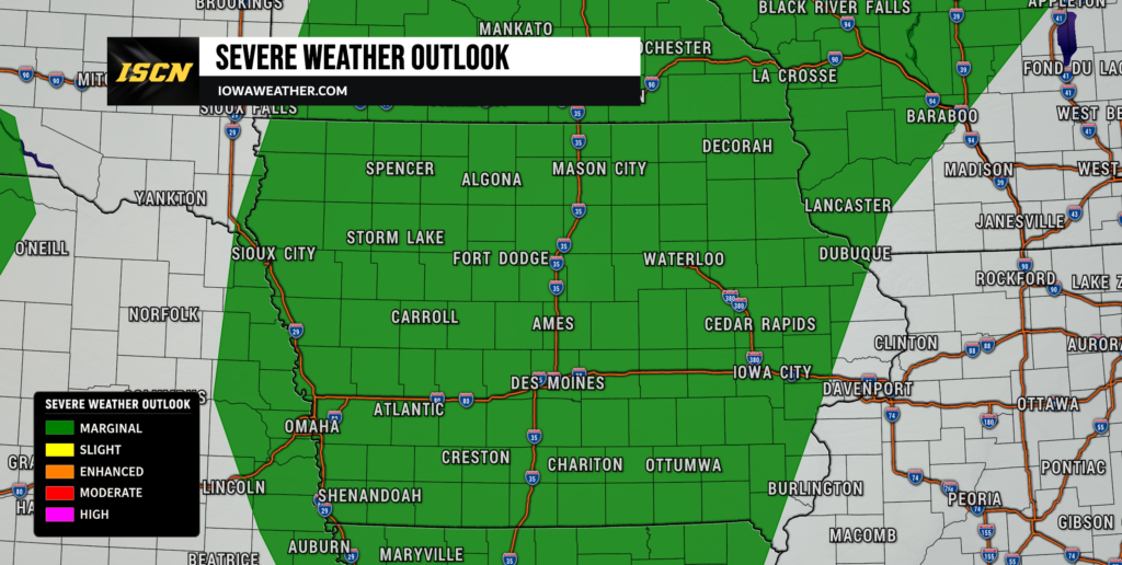
Iowa is entering an unsettled stretch of weather that will bring multiple opportunities for thunderstorms from Friday through the weekend and into next week. Not every round of storms will become severe, and there should be plenty of dry hours between storms, but damaging winds, isolated large hail and locally heavy rain will all need to be monitored. The first round arrives Friday as a cold front moves southeast across the state.
The Iowa weather forecast becomes more complicated this weekend because each round of thunderstorms may influence where the next one develops. Saturday and Sunday both carry additional severe weather potential, while increasing moisture could also support very heavy rainfall. Confidence is high that Iowa will remain in an active weather pattern, but confidence is considerably lower on the exact timing and placement of individual thunderstorm complexes.
Dense Fog Creates Problems Friday Morning
Dense fog is creating locally difficult travel conditions across parts of Iowa early Friday, with the greatest impacts across portions of central and southern Iowa. Visibility has dropped below one-half mile in some locations, while other areas are dealing with more patchy fog. Northeast Iowa is also seeing pockets of fog, although slightly stronger winds have prevented it from becoming as widespread in some areas. Light winds, clear skies and plenty of low-level moisture allowed temperatures to cool close to the dew point overnight, creating favorable conditions for fog development.
Drivers should be prepared for rapid changes in visibility during the morning commute, especially in low-lying areas and locations near rivers and streams. The fog will gradually improve after sunrise as temperatures rise and winds increase. Northern Iowa generally has a lower risk of widespread dense fog because winds have remained slightly stronger. Most areas should see significantly improved visibility by mid-morning. After the fog clears, attention quickly turns toward thunderstorms approaching from the northwest.
Thunderstorms Develop Across Iowa Today
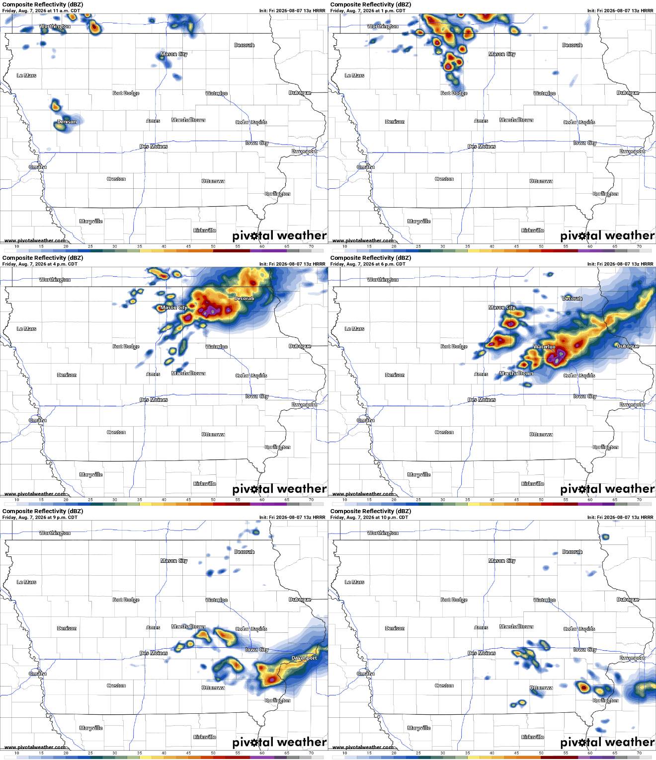
Thunderstorms are expected to become increasingly possible across Iowa on Friday as a cold front pushes southeast through the Upper Midwest. Northern Iowa has the highest opportunity for storms during the morning into midday, followed by a chance for activity to spread farther into central, western and eventually eastern Iowa. The exact evolution remains uncertain because thunderstorms developing upstream may organize into a larger complex before reaching the state. Current indications favor scattered rather than continuous storms, meaning some communities could receive rain while others remain completely dry.
One important factor will be how quickly Friday morning’s fog and cloud cover disappear. Clouds could delay heating and reduce the amount of instability available when the first storms arrive, which would make it harder for thunderstorms to become intense. If storms arrive later after the atmosphere has had more time to warm and destabilize, they could encounter a more favorable environment. Western Iowa appears to have one of the better combinations of instability and wind shear by Friday afternoon. Additional thunderstorms could then move into eastern Iowa later in the afternoon and evening before most areas trend quieter by mid-evening.
Damaging Winds Are the Main Severe Weather Threat
Much of Iowa has a Marginal Risk, or Level 1 of 5, for severe weather Friday, meaning isolated severe thunderstorms are possible. Damaging wind gusts are the primary concern, particularly if thunderstorms organize into a line or larger complex capable of maintaining itself while moving southeast. Isolated large hail is also possible, especially with storms that initially develop above a more stable layer of air. The severe weather threat is not expected to be widespread, but any stronger storm could still produce locally significant impacts.
The biggest uncertainty involves the timing and organization of thunderstorms. An earlier arrival would bring storms into an atmosphere that has experienced less daytime heating, reducing the available energy for severe weather. A later arrival could allow instability and wind shear to increase, creating a somewhat better environment for organized storms. This is why the severe weather forecast may change during the day as radar and satellite trends reveal how the upstream thunderstorms are evolving. Anyone with Friday afternoon or evening plans should keep an eye on local weather radar and be prepared to move indoors if a severe thunderstorm warning is issued.
Wildfire Smoke Remains Mostly Above Iowa
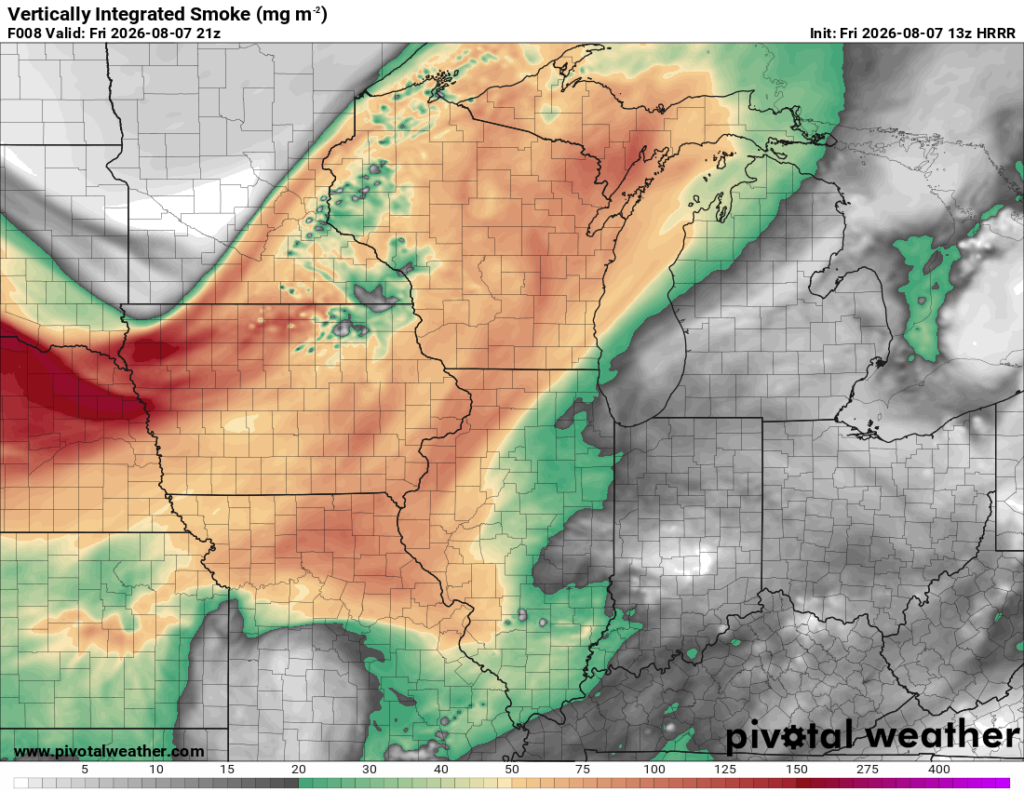
Wildfire smoke drifting south from Canada and the northern United States will remain present above portions of the region Friday. Most of the smoke is expected to stay elevated rather than becoming concentrated near the ground, so widespread surface air-quality problems are not currently the primary concern. The smoke may instead produce a hazier appearance to the sky, especially across western Iowa and neighboring Nebraska. It could also have a subtle effect on Friday’s temperature and thunderstorm forecast.
A thicker layer of smoke aloft can reduce the amount of sunlight reaching the surface, which may keep afternoon temperatures a few degrees cooler than they otherwise would be. That matters for today’s severe weather forecast because slightly cooler temperatures would also reduce atmospheric instability. Less instability could make it more difficult for storms to strengthen as they move across Iowa. The effect is expected to be relatively modest, but it adds another source of uncertainty to the timing and intensity of Friday’s storms. Anyone sensitive to smoke should continue checking current air-quality information in case more smoke mixes toward the surface.
Another Round of Severe Storms Possible Saturday
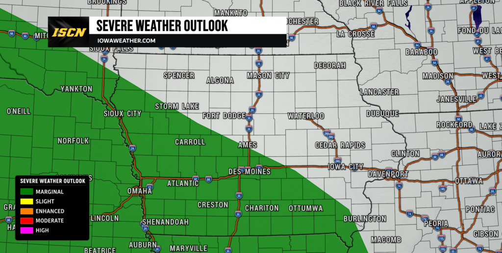
Thunderstorm chances continue Saturday, with western and southwestern Iowa appearing to have the greatest potential for stronger storms during the afternoon and evening. Thunderstorms may initially develop farther west over Nebraska before moving toward the Missouri River and western Iowa. The atmosphere is expected to become increasingly unstable as moisture returns, while stronger winds several thousand feet above the ground could help thunderstorms organize. Damaging wind gusts would again be the primary severe weather concern, although isolated hail is also possible.
Timing remains one of the biggest questions in Saturday’s forecast. Some guidance brings thunderstorms toward Iowa earlier in the day, when they could be weakening, while other scenarios favor redevelopment or strengthening closer to the late afternoon and evening. Southwest Iowa currently has higher confidence for afternoon thunderstorm activity, but the eventual track will depend partly on what happens with Friday’s storms. Areas farther east may remain dry for much of Saturday before storm chances increase Saturday night. Iowa remains under a Marginal Risk, Level 1 of 5, for severe thunderstorms Saturday.
Heavy Rain and Localized Flooding Become a Weekend Concern
Heavy rainfall becomes an increasingly important part of the Iowa weather forecast from Saturday night into Sunday. Atmospheric moisture will increase significantly, giving thunderstorms access to enough moisture to produce very efficient rainfall. Some storms could repeatedly move over the same locations, a process known as training, which can quickly increase rainfall totals even when individual thunderstorms are moving. Central and eastern Iowa could be particularly vulnerable to this scenario Saturday night, although the exact corridor remains uncertain.
The heavy rain threat may continue or increase again Sunday night as even deeper moisture moves into the region. Atmospheric moisture values could approach levels capable of supporting very high rainfall rates, especially where thunderstorms repeatedly develop near a stalled boundary. Urban areas would be particularly susceptible to flash flooding if several inches of rain fall within a short period. The risk is currently considered marginal rather than widespread, but flooding concerns would increase substantially if the same locations receive heavy rain during multiple rounds of storms. Residents should pay close attention to the rain forecast this weekend, particularly if they live in flood-prone or poorly drained areas.
Sunday Brings Another Chance for Strong Storms
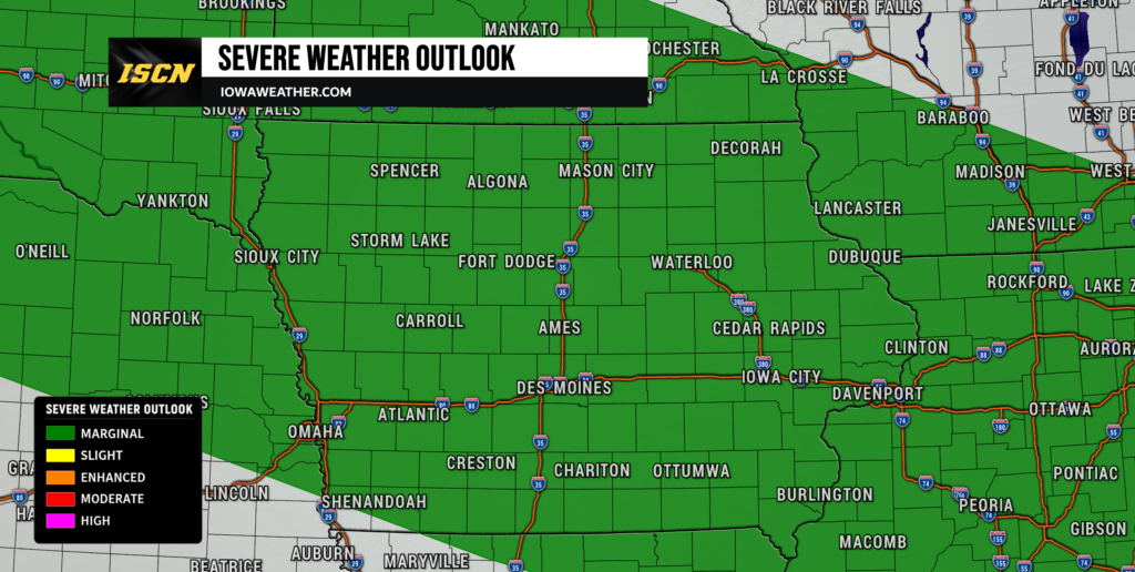
Another round of strong to severe thunderstorms is possible Sunday. A frontal boundary will remain somewhere across the region while warm, humid air continues flowing north into the state. Moderate to potentially strong instability could develop south of the boundary, providing enough energy for thunderstorms during the afternoon and evening. Damaging wind gusts are again expected to be the main severe weather hazard, with isolated hail also possible.
Sunday’s forecast has more uncertainty because its outcome depends heavily on where thunderstorms occur Friday and Saturday. Repeated storm complexes can push boundaries farther south through pools of rain-cooled air, meaning the eventual severe weather corridor may not end up exactly where current forecast guidance places it. If the boundary settles farther south, the strongest storms and heaviest rain could also shift south. If it remains farther north, a larger portion of Iowa could stay within the warm and unstable air mass. Confidence is high enough to continue monitoring Sunday for severe weather, but specific timing and locations should become clearer this weekend.
Heat and Humidity Build Sunday Into Monday
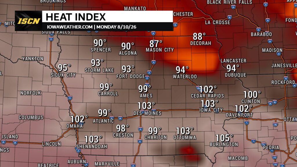
Temperatures will trend warmer Sunday and Monday as humid air spreads back across Iowa. Many locations should climb through the 80s, while areas that receive enough sunshine could approach or exceed 90 degrees. The most uncomfortable conditions may develop across southeastern Iowa and areas near the Mississippi River, where dew points could climb well into the 70s. That combination will make the weather feel noticeably more oppressive than the relatively comfortable conditions experienced earlier in the week.
Monday could bring the greatest heat index concerns, especially south of Interstate 80. There is currently a 20% to 30% probability of heat index values exceeding 100 degrees in portions of the region near and south of Interstate 80, although cloud cover and thunderstorms could limit temperatures. Even locations that remain below 100 degrees on the heat index will likely experience high humidity. The exact temperature forecast will depend on how much sunshine develops between rounds of rain and thunderstorms. People working or spending extended periods outdoors should be prepared for increasingly muggy conditions by late in the weekend.
Unsettled Weather Continues Next Week
The active weather pattern is unlikely to end when the weekend is over. Iowa will remain near a corridor of stronger winds aloft with several smaller disturbances moving through the region, keeping periodic thunderstorms in the forecast into the middle of next week. It will not rain continuously, and there should be plenty of dry periods between individual rounds. However, predicting exactly when storms will occur becomes difficult more than a day or two in advance in this type of pattern.
Repeated thunderstorms should gradually push the main boundary farther south as next week progresses. That could eventually focus the highest rain chances across southern Iowa while northern portions of the state trend somewhat drier. Temperatures should generally remain near seasonal averages, although warmer and more humid conditions are possible early in the week before somewhat cooler air returns. Additional strong storms cannot be ruled out because sufficient instability and wind shear may remain nearby. Confidence is relatively high in the overall unsettled pattern but low regarding the timing and placement of individual thunderstorms.
Stay with IowaWeather.com throughout the weekend for the latest Iowa weather forecast, storm timing, severe weather updates and changes to the heavy rain threat as each round of thunderstorms develops.