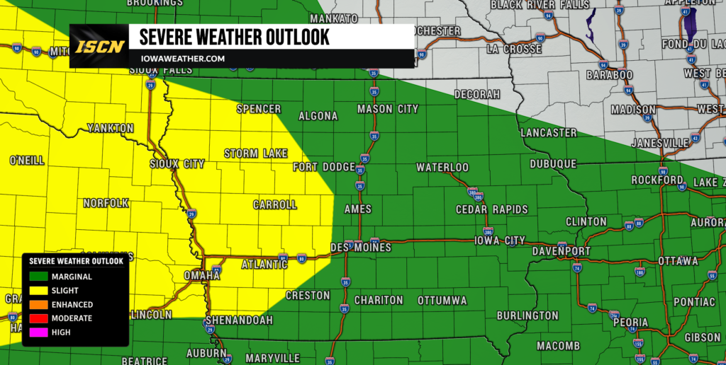
Another round of thunderstorms is taking aim at Iowa, and this one has a better chance of remaining organized as it reaches the state early Thursday morning. Storms developing across Nebraska and the Dakotas Wednesday evening are expected to merge into a larger complex overnight before advancing into western Iowa. Damaging winds and heavy rain will be the primary concerns, especially as the storms move east across the state during the morning. The exact track of the strongest portion of the storm complex remains somewhat uncertain, but central and western Iowa currently appear to have the greatest potential for stronger storms. Anyone looking at the weather tomorrow should be prepared for an unsettled start to Thursday.
The overnight storms will not necessarily be the end of the active weather. A stalled boundary near Iowa will remain a focus for additional thunderstorms Thursday afternoon, Thursday night and potentially into Friday morning. With unusually high moisture available, repeated thunderstorms could produce pockets of very heavy rain and localized flash flooding, particularly where multiple rounds cross the same locations. This active pattern also arrives as the Iowa State Fair opens Thursday in Des Moines, making storm timing especially important for thousands of people heading to the fairgrounds. There should be dry periods Thursday, but the forecast is not a simple all-day washout or all-day dry forecast.
Strong Thunderstorms Expected to Reach Iowa Early Thursday
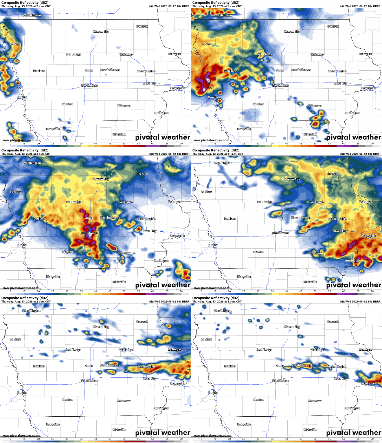
Thunderstorms are expected to organize across Nebraska Wednesday evening before forming a larger mesoscale convective system, or MCS, that moves east overnight. An MCS is essentially a large, organized cluster or line of thunderstorms that can travel for several hours and cover a broad area. Current guidance favors this complex reaching western and northwest Iowa during the pre-dawn hours Thursday, with the greatest concern beginning roughly after 2 a.m. in northwest Iowa before spreading farther east. The storms may then track across portions of central Iowa during the morning, potentially near the Interstate 80 corridor, although that exact path remains uncertain. A surge of warm and humid air above the ground will continue feeding the storms overnight, giving them a better opportunity to maintain their strength as they enter Iowa. Confidence is high that thunderstorms will affect at least part of Iowa Thursday morning, while confidence is lower on precisely where the most intense wind corridor develops.
This system has somewhat stronger upper-level support than the storm complexes Iowa has dealt with during the previous couple of nights. Instability of more than 2,000 joules per kilogram is expected to remain available near the storm track, providing ample energy for thunderstorms even during the overnight hours. Wind shear, or the change in wind speed and direction with height, will also be strong enough to keep the complex organized. The most likely evolution is for individual storms farther west to merge into a line or bowing cluster as they approach eastern Nebraska and Iowa. That favors damaging straight-line winds rather than a widespread tornado threat. Residents should have a way to receive any severe thunderstorm warning that may be issued while most people are sleeping.
Heavy Rain and Flash Flooding May Become the Bigger Concern
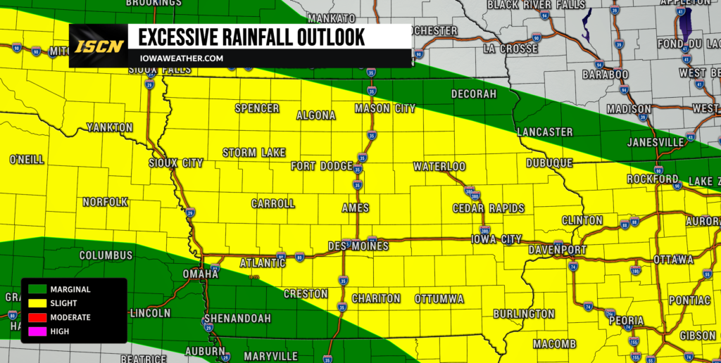
The amount of moisture available to these storms is unusually high, which means rainfall could become just as important as the severe wind threat. Atmospheric moisture values are expected to approach or exceed two inches in portions of Iowa Thursday, placing the environment firmly in a range capable of producing intense rainfall rates. Some thunderstorms may produce rain at rates near or above two inches per hour for brief periods. The first storm complex should generally keep moving, but even a progressive line can leave behind narrow swaths of two to three inches of rain. Where thunderstorms slow down, redevelop or repeatedly move across the same area, rainfall totals could climb substantially higher. That raises the risk of ponding on roads, rapid rises in small streams and localized flash flooding.
The flooding risk may increase further later Thursday because the boundary responsible for the storms will remain close to Iowa. New thunderstorms could repeatedly develop along that boundary rather than quickly clearing the state. Several high-resolution forecast models indicate the potential for localized three to six inch rainfall totals through portions of Iowa, although those amounts will be highly dependent on exactly where storm training occurs. The greatest concern is not that everyone receives several inches of rain, but that a narrow corridor could be hit by multiple rounds while nearby communities receive considerably less. Parts of Iowa already have wet ground from recent storms, which means additional heavy rain may run off more efficiently. Anyone traveling Thursday should check the rain forecast and local radar because conditions could vary dramatically over relatively short distances.
Iowa State Fair Opening Day Weather: What to Expect Thursday
Opening day of the Iowa State Fair on Thursday, August 13, could begin on a wet and stormy note in Des Moines. The most likely scenario brings an organized thunderstorm complex through central Iowa sometime during the morning, although the exact arrival and departure time will depend on the overnight track. If the line follows the current favored corridor near Interstate 80, Des Moines could experience heavy rain, lightning and potentially strong wind during the morning hours. Those heading to the fairgrounds early Thursday should check weather radar before leaving home and be prepared for possible delays or changes to outdoor activities. There is a reasonable chance conditions improve for a period after the morning storms move away. However, Thursday’s weather cannot be treated as a simple case of rain ending for the day.
Additional scattered thunderstorms may redevelop Thursday afternoon or evening as the atmosphere recovers and a boundary remains nearby. Coverage during the afternoon is more uncertain than the morning round, so there should be many dry hours between storms even if additional development occurs. Temperatures around Des Moines are also expected to be held somewhat in check by clouds and morning rain, with central Iowa generally reaching the upper 70s to lower 80s instead of the more intense heat experienced earlier this week. Humidity will remain high, however, so it may still feel muggy on the fairgrounds even without extreme afternoon temperatures. Lightning would be the primary concern for outdoor fair activities if afternoon thunderstorms redevelop, along with brief torrential rain and gusty winds. Fairgoers should keep an eye on updated radar and alerts throughout the day rather than relying solely on the morning forecast.
More Storms Thursday Night Into Friday Raise the Flooding Risk
Another round of thunderstorms may organize Thursday night into early Friday as the low-level jet strengthens again. The exact placement of this next round is more uncertain because it will depend heavily on what happens with Thursday morning and afternoon thunderstorms. Outflow boundaries left behind by earlier storms can shift the corridor of greatest instability by dozens of miles, which makes precise placement difficult more than a day in advance. Portions of central, eastern and northern Iowa could remain in the zone for repeated thunderstorms, while other areas may experience much less activity. Strong or locally severe storms are possible, with damaging wind and hail remaining concerns. Heavy rain may once again become the most widespread impact.
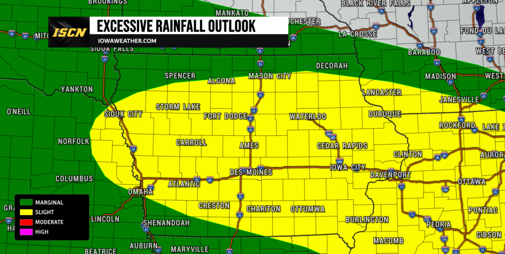
Storm movement Thursday night could also become less progressive than the initial Thursday morning complex. If thunderstorms develop parallel to the stalled boundary, storms may repeatedly pass over the same areas rather than quickly moving through. This process, known as training, is one of the most efficient ways to produce flash flooding. Atmospheric moisture will remain near levels capable of supporting very heavy rainfall rates, so flooding could develop quickly where storms repeat. The excessive rainfall outlook highlights Iowa as one of the more concerning areas for this possibility Thursday into Friday. Flooding confidence is moderate overall but could increase substantially once the location of Thursday’s boundaries becomes clearer.
Heat Eases Some, but Humidity Stays High
The repeated rounds of storms will knock temperatures down across much of Iowa compared with the hottest days earlier this week. Northern and central Iowa should generally see highs in the upper 70s to lower 80s Thursday, while southern Iowa could still approach the upper 80s or around 90 degrees. Cloud cover, rainfall and the timing of morning thunderstorms will determine how warm individual communities become. Areas that remain cloudy through midday could stay considerably cooler than locations that break into sunshine during the afternoon. This should reduce the widespread heat index concerns for much of the state Thursday. Southern Iowa will still feel warmer and more humid, especially where the sun returns.
The drop in temperature will not come with a major drop in humidity. Dew points are expected to remain well into the 60s and in some locations the lower 70s, which will keep the air feeling muggy. That moisture is also one reason thunderstorms will continue to be capable of producing such heavy rain. Friday and Saturday temperatures should remain fairly seasonable in many areas, although exact highs will again depend on the location of clouds and thunderstorms. A somewhat cooler air mass becomes more likely by Sunday and early next week, particularly across northern Iowa. Highs in the 70s and lower 80s may become more common as the overall storm track shifts.
Active Pattern Continues Into the Weekend
Iowa will remain positioned along the northern edge of a strong ridge of high pressure into the weekend, a setup meteorologists often call the “ring of fire.” The ridge itself suppresses thunderstorms farther south, while disturbances travel around its northern edge through the Plains and Midwest. Iowa sits close enough to that storm track that additional clusters of thunderstorms can periodically move through the state. Another round is possible Friday, followed by additional chances Saturday and Saturday night. The timing of each individual round remains uncertain because every previous storm can alter the location of the boundary for the next one. This makes the weather this week more predictable in terms of the overall active pattern than in the exact hour-by-hour timing several days in advance.
That does not mean the entire weekend will be rainy. There should be extended dry periods each day, and some locations may miss one or more rounds entirely. Saturday currently appears to have another opportunity for showers and thunderstorms, with locally heavy rain possible if storms organize along the lingering boundary. The front may gradually shift farther south by Sunday, which could reduce rain chances in northern Iowa and allow somewhat cooler air to spread across the state. There is still uncertainty in how quickly that boundary moves, so weekend plans should continue to be checked against updated forecasts. The risk for widespread organized severe weather appears lower after Thursday, but isolated strong storms and heavy downpours will remain possible.
Looking Ahead
The overall pattern remains unsettled into early next week, although the most concerning period for organized severe weather and flooding appears focused from early Thursday through Friday. Periodic disturbances will continue moving around the northern edge of the upper-level ridge, keeping at least occasional thunderstorm chances in the forecast. Cooler temperatures should become more established Sunday through Tuesday, with many Iowa communities seeing highs in the 70s to lower 80s. There may also be longer dry windows as the main frontal boundary gradually shifts, but confidence in the exact timing of those quieter periods remains fairly low. Additional thunderstorms cannot be ruled out Monday or Tuesday as smaller disturbances move through the faster northwest flow aloft. Forecast confidence should improve once the repeated rounds of storms Thursday and Friday determine where the primary boundary ultimately settles.
For the next 24 to 48 hours, the biggest things to watch are the track and strength of Thursday morning’s storm complex, where additional storms redevelop Thursday afternoon and night, and whether repeated heavy rain begins producing flooding problems. Iowa State Fair visitors should pay particularly close attention to radar and updated forecasts before heading to Des Moines on opening day Thursday. Keep checking IowaWeather.com for the latest Iowa weather updates, storm timing, radar trends and changes to the severe weather or flooding forecast.