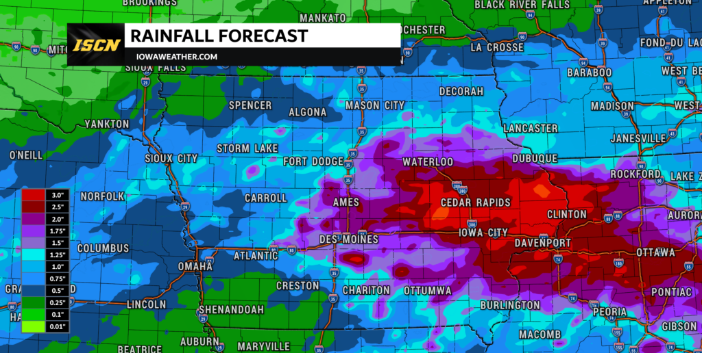
Iowa remains locked in an active weather pattern, and another round of thunderstorms is expected to develop Thursday evening before expanding overnight. While a few storms could become severe, the most significant concern is increasingly becoming heavy rain and flash flooding, especially across central and eastern Iowa. Several rounds of rain have already moved through the state this week, leaving parts of Iowa more sensitive to additional downpours. The atmosphere also contains an unusually deep supply of moisture, allowing thunderstorms to produce very high rainfall rates in a short amount of time. That combination means locations that repeatedly get hit by storms could experience flooding even if nearby communities receive considerably less rain.
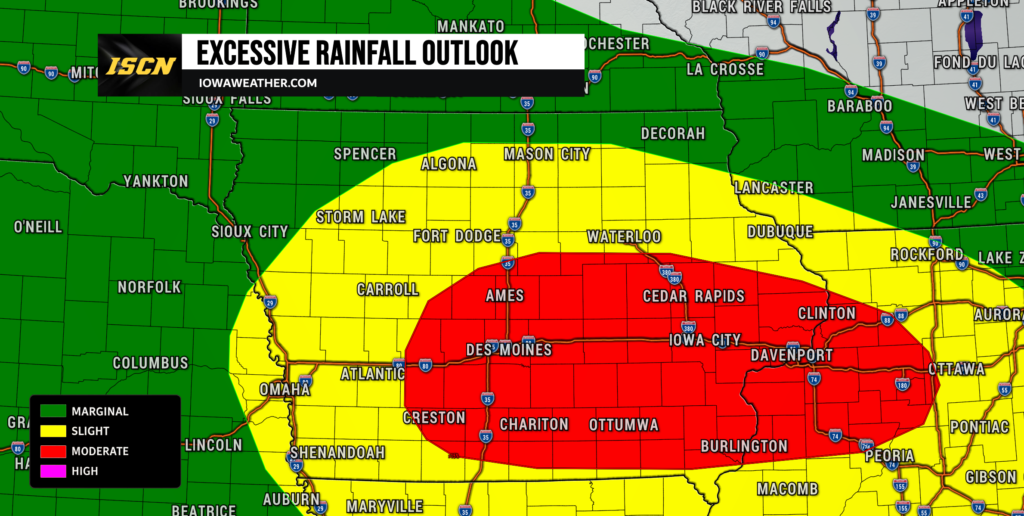
Friday may bring an even greater flooding concern as another disturbance moves into Iowa and thunderstorms redevelop during the afternoon and evening. A Moderate Risk of excessive rainfall has now been introduced for a large portion of Iowa into northwest Illinois for Friday into early Saturday, signaling the potential for more significant flash flooding within the hardest-hit corridor. Exactly where the heaviest rain sets up remains uncertain because thunderstorms will likely organize along narrow boundaries that can shift north or south by several counties. Even so, confidence is high that additional thunderstorms and locally heavy rainfall will affect Iowa through Friday night. Residents should be prepared for rapidly changing conditions and pay close attention to the weather forecast and local radar, particularly if they live in an area that has already received substantial rain.
Flash Flooding Becomes the Main Weather Concern
Flooding is likely to be the most important weather story across Iowa through Friday night. Atmospheric moisture values will climb to around or above two inches, which is a very moist environment for Iowa and allows thunderstorms to produce intense rainfall efficiently. A widespread 1 to 3 inches of additional rain is possible within the main storm corridor, but localized amounts could become considerably higher where thunderstorms repeatedly move over the same locations. Some high-resolution forecast guidance shows localized totals above 5 inches, although those extreme amounts will depend heavily on exactly where storm training occurs. The greatest concern currently extends from central Iowa into portions of eastern Iowa, where repeated storms tonight and again Friday could overlap areas that have already received heavy rain.
Flash flooding can develop quickly when several thunderstorms track across the same community, especially in cities where pavement and drainage systems cannot absorb rainfall fast enough. Rural areas normally have greater capacity to handle summertime rainfall, but repeated rain this week has reduced how much additional water some soils can absorb. Streams, creeks and rivers are also expected to rise, and at least isolated to scattered minor river flooding could develop. If rainfall totals exceed current expectations by even an inch in some watersheds, the response on area rivers could become substantially greater. Forecast confidence is high that heavy rain will occur somewhere across the state, while confidence remains lower regarding the exact location of the narrow corridor receiving the highest totals.
Thunderstorms Redevelop Thursday Evening and Overnight
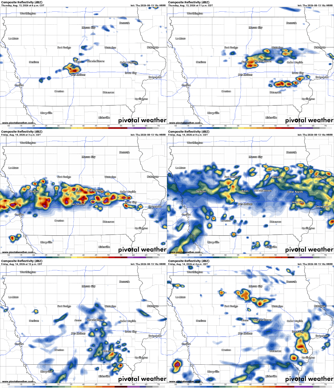
For anyone wondering when storms will arrive tonight, scattered development is possible during the evening before thunderstorms become more numerous later tonight. The environment should become increasingly favorable after roughly 9 PM as a strengthening low-level jet transports warm, humid air into a nearly stationary boundary across Iowa. Central Iowa currently appears favored for increasing thunderstorm coverage during the late evening and overnight hours, with storms potentially expanding north and east toward Friday morning. The most active period may occur after midnight, when repeated development along the same west-to-east corridor becomes possible. Rain and storms should gradually decrease Friday morning, but the break may not last very long.
Unlike several earlier storm systems this week that developed farther west and then moved into Iowa as organized complexes, tonight’s thunderstorms may develop more directly over the state. That makes the exact placement of the heaviest rainfall particularly difficult to predict because subtle boundaries left behind by earlier thunderstorms can determine where new storms repeatedly form. Areas near and south of Highway 20 through central and eastern Iowa remain especially important to watch, including communities near the Interstate 80 corridor. Northwest Iowa could also see showers and thunderstorms overnight into Friday morning, although the most persistent heavy-rain axis currently appears more likely to remain farther south. Checking live weather radar before traveling late tonight or early Friday morning will be important because rainfall rates could change road conditions quickly.
Damaging Wind, Large Hail and an Isolated Tornado Remain Possible
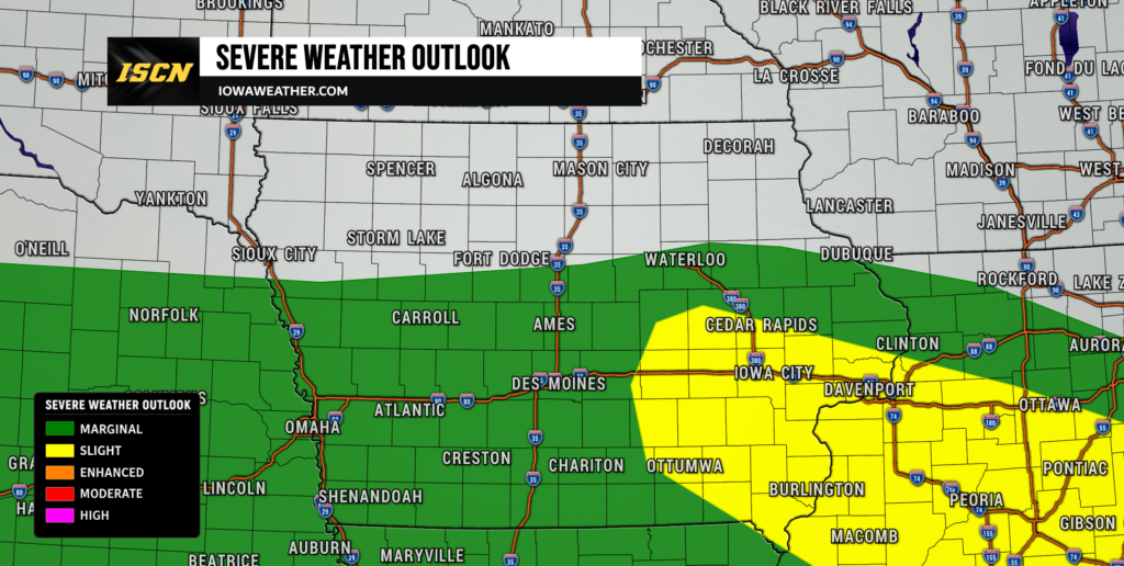
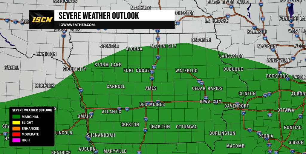
Heavy rainfall is the primary concern, but there is still a severe weather threat with some thunderstorms tonight and again Friday. The atmosphere will contain plenty of instability, which means stronger thunderstorms could produce large hail or damaging wind gusts. Portions of eastern Iowa remain within the broader Slight Risk for severe thunderstorms Thursday, while most of the severe threat becomes more isolated farther west. Storm organization may be somewhat limited tonight because winds higher in the atmosphere are not particularly strong, making a widespread or long-lived severe weather event less likely. Even so, brief bowing segments could produce pockets of damaging winds, and stronger individual cells could produce hail.
There is also a low but non-zero tornado threat, particularly if a storm can develop near a surface boundary where winds closer to the ground are locally enhanced. The best opportunity for that type of storm Thursday evening would be across portions of southern or central Iowa, although several factors may prevent storms from fully taking advantage of that environment. Friday brings another conditional tornado risk as a weak area of low pressure crosses Iowa and low-level wind shear potentially increases. A few storms could briefly develop supercell characteristics before eventually clustering together. The overall tornado threat remains isolated, and residents should view flooding and damaging winds as the more widespread concerns while still remaining prepared if a warning is issued.
Another Significant Round of Storms Expected Friday
Iowa may receive a relative break from storms Friday morning before the atmosphere quickly reloads for another active afternoon and evening. A small-scale circulation left behind by previous thunderstorms, known as an MCV, is expected to move into the region and help generate new storms. Exactly when thunderstorms begin remains uncertain, with some forecast guidance developing storms during the late afternoon and other solutions delaying widespread development until Friday evening. If enough clearing occurs beforehand, pockets of stronger instability could develop and support a few severe thunderstorms. More importantly, the combination of weak steering winds and extremely high atmospheric moisture could result in slow-moving or repeatedly developing storms.
Friday evening through early Saturday morning currently represents the period of greatest concern for significant rainfall totals. The Moderate Risk of excessive rainfall reflects growing confidence that thunderstorms could repeatedly track over portions of Iowa into northwest Illinois. Probabilities from high-resolution ensemble guidance show a meaningful signal for localized rainfall totals exceeding 5 inches within the broader risk area, although those totals will not occur everywhere. Some locations may receive considerably less rain if the main storm corridor sets up only a few counties away. Because the difference between manageable rainfall and significant flooding could come down to relatively small shifts in storm placement, Friday’s local weather forecast will need to be monitored closely throughout the day.
Why Training Storms Could Produce So Much Rain
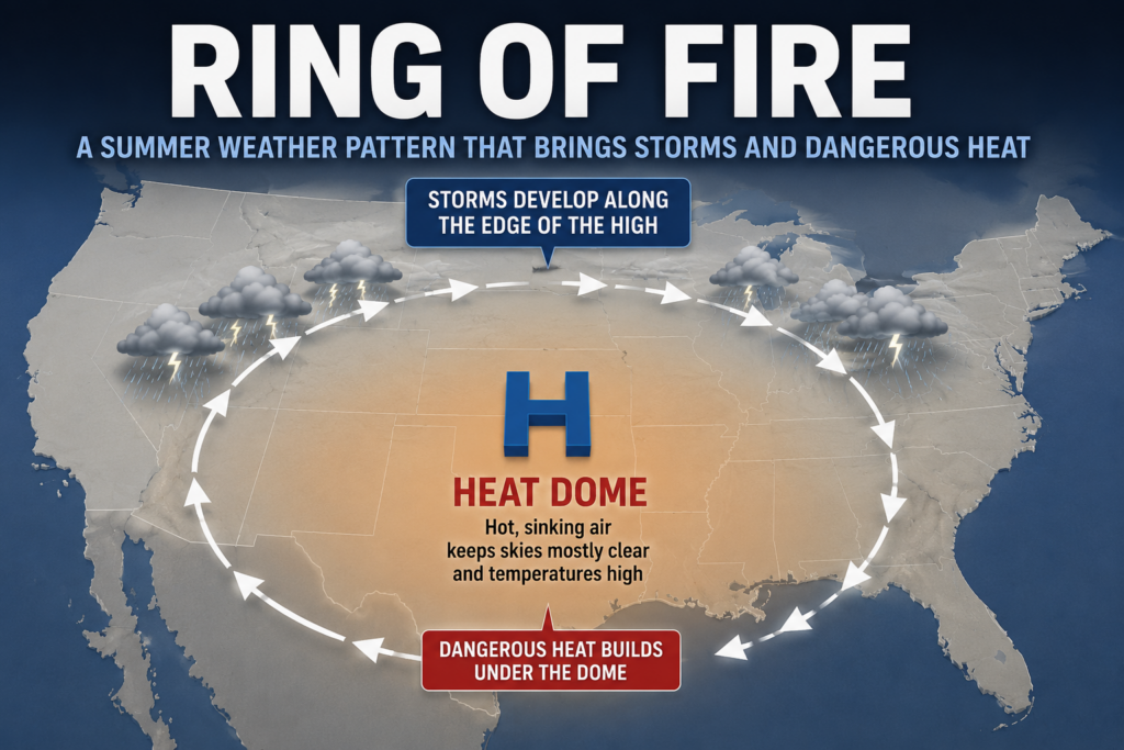
The atmosphere over Iowa is essentially operating along the northern edge of a large summertime ridge of high pressure centered farther south. Small disturbances continue traveling around the edge of that ridge, following a corridor meteorologists sometimes call the “ring of fire.” Each disturbance interacts with a stalled frontal boundary and a deep supply of Gulf moisture, repeatedly providing opportunities for thunderstorms to develop. Because the larger weather pattern is moving very slowly, storms can return to the same general areas night after night. This is why cumulative rainfall has become increasingly important even in places that handled the first few rounds without flooding.
Thunderstorms may also move nearly parallel to the boundary Thursday night and Friday, allowing multiple cells to pass over the same location. This process is called training because the storms behave somewhat like train cars following the same track. With atmospheric moisture near or above two inches, individual thunderstorms may produce very heavy rain rates, potentially several inches within only a few hours. The precise training corridor could be narrow, which explains why rainfall totals may vary dramatically over relatively short distances. Confidence in the overall heavy-rain setup is high, but pinpointing the communities that receive the maximum rainfall will likely remain difficult until storms actually develop and boundaries become clearer on radar.
Travel Impacts Could Increase Thursday Night Through Saturday Morning
Travel conditions may deteriorate quickly during periods of heavy rain, especially Thursday night and Friday night. Urban streets, low-lying intersections and roads near small creeks can flood rapidly when thunderstorms produce intense rainfall rates. Water may also cover rural roads in areas where drainage is poor or where nearby streams leave their banks. Drivers traveling before sunrise Friday should be particularly cautious because standing water is much more difficult to recognize in darkness. Never drive through a flooded roadway, even if the water appears shallow, because the road underneath may be damaged or the current may be stronger than it looks.
Low clouds and patchy fog may create an additional travel concern across northern and northwest Iowa during the overnight and morning hours. Recent rainfall has left considerable moisture close to the ground, and weak winds may allow low stratus clouds and fog to redevelop. Visibility impacts are not expected everywhere, but some locations could experience reduced visibility Friday morning and again during the weekend. Thunderstorms will create the greater travel concern across central and eastern Iowa because visibility can fall rapidly within heavy downpours. Anyone with travel plans should check the latest weather radar and road conditions before leaving and be prepared for slower travel where storms occur.
Storm Chances Continue Into the Weekend
The active weather pattern will not immediately end once Friday night’s storms move away. Another disturbance may cross the region Saturday, maintaining at least scattered thunderstorm chances across Iowa. The exact placement of the main storm corridor may shift somewhat farther north and northeast as the stalled boundary begins lifting as a warm front. Heavy rainfall will remain possible, particularly in places where the ground is already saturated from Thursday and Friday. A few stronger thunderstorms could also develop Saturday, although uncertainty remains high because the amount of instability will depend on earlier clouds and precipitation.
A cold front is expected to gradually move through the region by Sunday, helping push the deepest moisture farther east. Sunday currently appears to offer a better opportunity for quieter weather across at least parts of Iowa, although an isolated shower or thunderstorm cannot be completely ruled out in every location. Cooler and somewhat drier air should become more noticeable behind the front, especially across northern Iowa. The break may be relatively brief because additional disturbances are expected to travel through the northwest flow early to middle next week. Forecast confidence becomes lower with each of those individual waves, but the broader pattern continues to favor periodic rain and thunderstorm chances.
Looking Ahead
The next 36 to 48 hours deserve the most attention, with repeated thunderstorms and heavy rain creating a growing flooding concern across Iowa. Thunderstorms should increase again Thursday night, decrease for a time Friday morning, and then redevelop Friday afternoon into Friday night. Central and eastern Iowa currently appear most likely to experience the highest rainfall totals, but even relatively small changes in storm tracks could shift that corridor north or south. Severe thunderstorms capable of damaging winds, hail and an isolated tornado remain possible, though flooding is expected to be the more widespread impact. Saturday brings additional storm chances before a cold front provides at least a temporary push of cooler and drier air later in the weekend.
Early next week should feature temperatures closer to or below seasonal averages, but the weather pattern may remain somewhat unsettled. Northwest flow aloft can carry additional small disturbances into Iowa, creating periodic opportunities for showers and thunderstorms Monday through the middle of next week. Confidence is fairly high in the cooler overall temperature trend but much lower regarding the timing and coverage of individual storms several days in advance. The amount of rainfall received through Saturday will also determine how vulnerable streams and rivers remain to any additional rainfall next week. Residents should continue monitoring forecasts even after the current round ends because hydrologic impacts can continue after thunderstorms have moved away.
Stay with IowaWeather.com for the latest Iowa weather forecast, live weather radar updates, rainfall information and changes to the severe weather and flooding threats as new data becomes available.