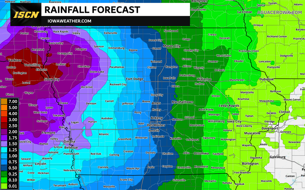
Iowa’s recent stretch of cloudy, cool, and rainy weather will continue to influence the forecast as we officially transition into fall. While much of the state will enjoy a temporary break from widespread rainfall on Wednesday, another weather system will bring showers and occasional thunderstorms back into Iowa beginning late Wednesday night and Thursday. The greatest rain chances will initially favor western Iowa before spreading farther east Friday and Saturday. Locally heavy rainfall will be the primary concern, especially in areas where recent rainfall has already saturated the ground.
The Iowa weather forecast for the remainder of the week features temperatures running below normal, limited sunshine, and several opportunities for additional rainfall. Wednesday should provide one of the better opportunities for outdoor activities, although clouds and patchy morning fog could linger in some areas. Rain chances will increase across western Iowa Thursday, with more widespread showers and occasional thunderstorms expected Friday into Saturday. Severe weather is not currently anticipated, but additional rainfall could create localized flooding concerns in areas that have already received substantial precipitation.
There is some encouraging news for those hoping to enjoy a little sunshine. A temporary shift in the weather pattern should bring drier conditions and warmer temperatures to much of Iowa by Sunday. However, that break may not last long, as another weather system could bring renewed rain chances during the first half of next week.
Tonight: Patchy Fog Possible as Temperatures Fall
As the remaining drizzle diminishes Tuesday evening, attention will turn toward the potential for patchy fog developing overnight into Wednesday morning. Light winds and lingering moisture near the ground will create favorable conditions for fog, especially across western Iowa and in low-lying areas. The greatest uncertainty involves how quickly the cloud cover breaks apart, as clearing skies could allow temperatures to fall more rapidly and increase the potential for fog formation. Some areas may remain cloudy enough to limit cooling and prevent widespread fog from developing. Motorists traveling late tonight or early Wednesday should be prepared for the possibility of reduced visibility in locations where fog forms.
Overnight temperatures will generally fall into the 40s and lower 50s across Iowa, with the coolest readings expected in the northeastern part of the state. A few locations in northeastern Iowa could approach the lower 40s if skies clear for an extended period. Farther northeast, portions of central and north-central Wisconsin may experience temperatures cold enough for patchy frost Wednesday morning. Widespread frost is not currently expected across Iowa, although temperatures will certainly provide a reminder that the fall season has arrived. Any fog that develops should gradually dissipate Wednesday morning as daytime heating and increasing winds help improve visibility.
Wednesday: A Drier Day With Some Welcome Sunshine
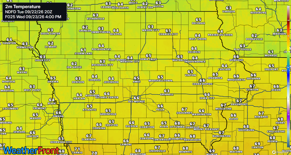
Wednesday should offer Iowa residents a temporary break from the recent wet weather, with most of the state expected to remain dry throughout the day. High pressure extending into the region will help push some of the lingering moisture away, allowing clouds to gradually thin and break apart. Eastern and central Iowa may see improving sky conditions during the morning, with clearing gradually extending into western portions of the state by midday or afternoon. However, the atmosphere will retain enough moisture for additional clouds to develop, particularly across eastern Iowa and areas along and east of Interstate 35. This means Wednesday will likely feature a mixture of clouds and sunshine rather than completely clear skies.
High temperatures will generally reach the 60s across Iowa, keeping conditions cooler than normal for this time of year. Despite the below-average temperatures, Wednesday should provide a more comfortable opportunity for outdoor activities as the widespread drizzle and showers temporarily come to an end. Some light precipitation could develop near the western and northwestern edges of the state as the next weather system begins approaching from the Plains. However, most Iowa communities should experience several hours of dry weather before rain chances begin increasing again Wednesday night. The improving conditions will be relatively short-lived as moisture and atmospheric energy begin returning to the region ahead of another approaching disturbance.
Wednesday Night Into Thursday: Showers and Storms Return to Western Iowa
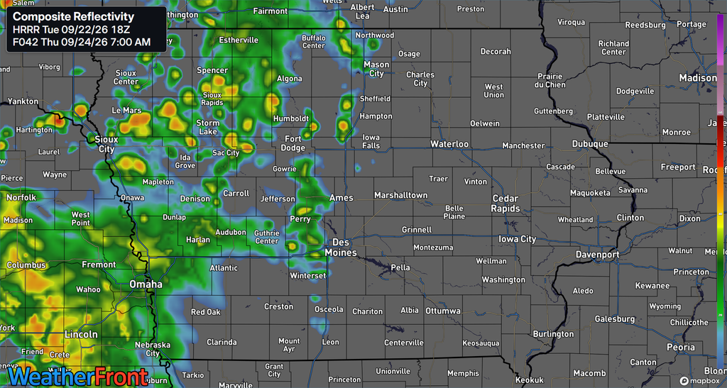
The next round of unsettled weather will begin taking shape Wednesday afternoon and evening as a weather disturbance moves northeastward across the northern Plains. Increasing southerly winds above the ground will transport warmer, moisture-rich air into the region, helping showers and thunderstorms develop across portions of South Dakota and Nebraska. A more organized area of precipitation is expected to move eastward Wednesday night, approaching the Interstate 29 corridor by early Thursday morning. This activity could bring rain into northwestern and western Iowa overnight, with additional showers and occasional thunderstorms developing across western portions of the state Thursday. The exact timing and coverage remain somewhat uncertain, but confidence is increasing that western Iowa will experience a return to wet conditions during this period.
Rain chances Thursday will generally be highest across western Iowa, including communities near Sioux City, Council Bluffs, and areas extending eastward toward Carroll and Fort Dodge. Central Iowa may also experience scattered showers, although the most persistent precipitation is expected to remain farther west during much of the day. Farther east, communities such as Cedar Rapids, Iowa City, Davenport, and Dubuque have a better opportunity to remain predominantly dry as high pressure near the Great Lakes continues to influence the region. Some isolated showers cannot be ruled out across eastern Iowa, but widespread rainfall is not currently anticipated there on Thursday. High temperatures will remain mainly in the 60s statewide, with extensive cloud cover limiting daytime warming.
The potential for locally heavy rainfall will increase as moisture levels rise across the region ahead of the approaching weather system. While thunderstorms are possible, the atmosphere is not expected to contain enough instability to support a widespread severe weather threat. Instead, the primary concern will be periods of moderate to heavy rainfall, particularly where showers and thunderstorms repeatedly move across the same locations. Some temporary ponding of water could develop on roads and in areas with poor drainage during the heavier downpours. Rain chances should continue across western Iowa Thursday evening and may begin spreading farther east overnight into Friday morning as the system gradually progresses across the state.
Friday and Saturday: Widespread Rain Chances Continue
Friday is shaping up to be one of the wetter days of the week across western and central Iowa as additional atmospheric disturbances move through the region. Moisture flowing northward from the southern Plains will interact with these disturbances, supporting repeated rounds of showers and occasional thunderstorms. Rain chances will be particularly high across western Iowa, where some locations could experience precipitation during both the morning and overnight hours. Central Iowa will also see increasing opportunities for rainfall as the system gradually shifts eastward. However, the precipitation is not expected to fall continuously throughout the day, and there will likely be breaks between individual rounds of showers.
Eastern Iowa faces a more uncertain rainfall forecast, particularly for communities near the Mississippi River. High pressure and drier air to the east may initially limit how far the more widespread precipitation can advance across the state. Areas west of a line extending from Dubuque to Keokuk currently have a greater opportunity to experience rainfall through the weekend, while locations farther east may remain predominantly dry for longer periods. The exact placement of this transition zone will depend on how quickly the approaching disturbances move east and how effectively they overcome the drier air. As a result, rainfall timing and amounts across eastern Iowa remain less certain than they are across western portions of the state.
Additional showers and occasional thunderstorms will remain possible Friday night into Saturday as another disturbance moves through the region. Western Iowa may begin experiencing improving conditions during Saturday as the precipitation gradually shifts eastward. Central and eastern Iowa could continue seeing periods of rain into Saturday, although the exact timing of the final showers remains uncertain. Extensive cloud cover will keep temperatures on the cool side, with highs generally in the 60s and some western locations potentially reaching the lower 70s as conditions improve. The overall trend should favor decreasing rain chances from west to east during the second half of the weekend.
Temperatures: Cool Weather Continues Before a Weekend Warmup
The arrival of fall will be accompanied by temperatures that remain below seasonal averages across much of Iowa through the end of the workweek. High temperatures Wednesday, Thursday, and Friday will generally remain in the 60s as persistent cloud cover and occasional rainfall limit daytime warming. This is several degrees cooler than the temperatures typically experienced across Iowa during late September, when afternoon highs are commonly in the lower to middle 70s. The coolest conditions will generally occur in areas experiencing the most extensive cloud cover and precipitation. Overnight temperatures will remain relatively cool as well, although increasing moisture and clouds should help limit the more substantial nighttime cooling experienced in some areas earlier in the week.
A gradual warming trend should begin developing over the weekend as the unsettled weather pattern temporarily weakens. Western Iowa may begin seeing temperatures climb into the lower 70s Saturday as rainfall decreases and some sunshine returns. Eastern Iowa could remain cooler for longer if clouds and showers persist into the day. By Sunday, much of Iowa should experience a more noticeable improvement, with afternoon temperatures recovering into the 70s. Some southwestern locations could approach the upper 70s as warmer air spreads into the region, bringing temperatures closer to seasonal averages.
Sunday: A Welcome Break From the Rain
Sunday currently offers the most promising opportunity for widespread dry weather across Iowa during the upcoming weekend. As the final disturbance associated with the late-week weather system moves away, sinking air behind it should help suppress additional shower development. This change will allow cloud cover to gradually decrease, with increasing opportunities for sunshine across much of the state. Western Iowa may begin experiencing improving conditions Saturday, while central and eastern Iowa could see the more noticeable improvement Sunday. Although some lingering clouds may remain, the overall forecast favors a substantially drier day compared to Friday and Saturday.
Temperatures should also respond to the improving conditions, with highs climbing into the 70s across much of Iowa. The combination of warmer temperatures, lighter precipitation chances, and increasing sunshine should make Sunday a more favorable day for outdoor activities. However, locations that receive substantial rainfall during the preceding days may continue dealing with muddy ground, standing water, or elevated stream levels. Any lingering flooding concerns will depend on how much rain falls during the late-week system and how quickly water levels respond. Residents planning outdoor activities should also keep in mind that another round of unsettled weather could develop as early as Monday.
Stay updated with IowaWeather.com for the latest Iowa weather forecast, live radar, rainfall updates, and information about changing weather conditions across the state. You can also download the ISCN Weather app for convenient access to local weather information as the next round of rain approaches.