Another cool, cloudy and wet stretch of weather is underway across Iowa, and umbrellas will remain useful through the first half of the weekend. Periods of rain will continue across much of the state Friday, followed by another more widespread round of showers Friday night into Saturday. Temperatures will struggle because of the persistent clouds and rain, with much of Iowa remaining in the 60s Friday and many locations staying below average again Saturday.
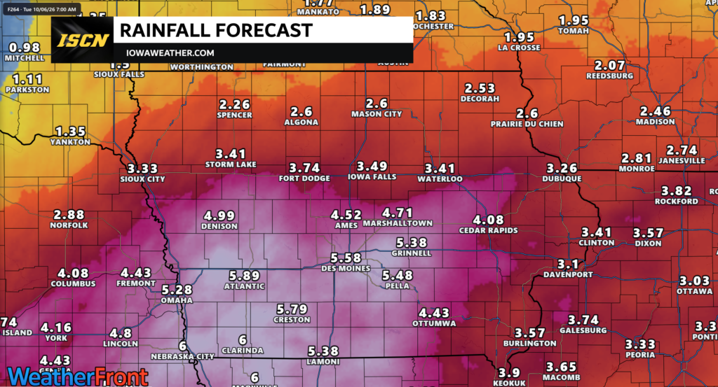
The weekend forecast is not a complete washout, but Saturday will be the wetter of the two weekend days for most of Iowa. Some locations could receive more than an inch of additional rain by Sunday, with parts of western and southwestern Iowa having the best chance of approaching or exceeding two inches. A few thunderstorms are possible, especially Saturday, but severe weather is not expected with this weekend’s system.
A break in the wet weather should develop Sunday and continue into much of Monday before attention turns to another potentially significant storm system. That system could draw a large amount of moisture northward into the Midwest and produce another round of widespread rain and thunderstorms Tuesday into Wednesday. With the ground already becoming wet from repeated rainfall, the potential for heavy rain and flooding will become increasingly important to monitor next week.
Rain Continues Across Iowa Today
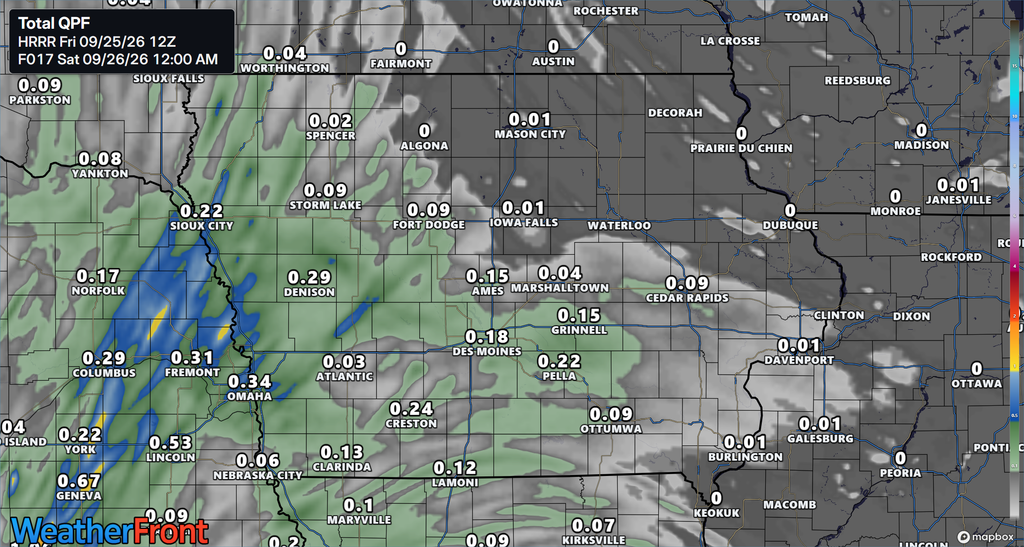
Friday’s weather will remain cloudy, cool and damp across much of Iowa as another disturbance moves through the region. Periods of rain will be most persistent across roughly the southern two-thirds of the state, while northern Iowa will see a mixture of scattered showers, drizzle and occasional breaks in the precipitation. Additional rainfall through the day will generally be light to moderate, with many locations picking up another tenth to one-half inch. Northwest Iowa may see lighter rainfall during the daytime before rain becomes more widespread again tonight. Instability is extremely limited, so thunderstorms will be uncommon and an isolated rumble of thunder would be about the most that occurs. If you are checking the weather today for outdoor plans or travel, expect wet roads, low clouds and temperatures that feel more like early October than late September.
Cloud cover and precipitation will also keep the temperature today well below what Iowa experienced during warmer stretches earlier this month. Highs across much of the state will remain in the 60s, with some locations struggling to climb very far through the day. The cool conditions are primarily the result of thick clouds limiting daytime heating rather than the arrival of particularly cold air. Eastern Iowa may see lighter and more scattered precipitation because somewhat drier air is working into that portion of the state. Even there, however, clouds should remain stubborn through much of Friday. Overall confidence in the cool and cloudy forecast is high.
Heavier Rain Develops Tonight Into Saturday
The next more organized round of rain will spread into Iowa late Friday night and continue through Saturday as another disturbance moves out of the central Plains. Moisture flowing northward will increase ahead of this system, allowing showers to become widespread from west to east. Many areas should receive at least another half-inch of rain, while locally heavier amounts near or above one inch are possible within the most persistent bands. Western, southwestern and portions of northwest Iowa are among the areas with the better potential for higher storm-total rainfall. By Sunday, there is high confidence that parts of Iowa will have received more than one inch of rain from the overall event, while portions of western and southwestern Iowa have roughly a 30% to 70% chance of exceeding two inches. Exactly where the heaviest rain band develops remains one of the main forecast details that could change.
Saturday afternoon could also bring more convective showers and embedded thunderstorms to southern Iowa as modest instability develops. This does not look like a severe weather setup, and widespread strong thunderstorms are not expected. Instead, thunderstorms could briefly increase rainfall rates and produce pockets of heavier rain. That means rainfall totals may vary considerably over relatively short distances, particularly where repeated showers or thunderstorms move over the same locations. Rain should gradually decrease from west to east later Saturday and Saturday night, although areas of drizzle or lingering light showers could remain. Anyone with Saturday outdoor plans should continue checking the local weather forecast and weather radar because the exact timing of breaks in the rain will vary across Iowa.
Flooding Risk Remains Limited This Weekend but Bears Watching
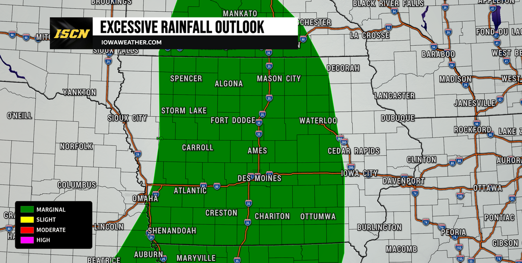
Despite the potential for locally heavy rainfall, widespread flash flooding is not currently expected with the Friday and Saturday rounds. Much of the rain should fall over a long enough period to limit how quickly water accumulates, which reduces the immediate flash flood threat. Still, heavier downpours could produce ponding on roads, standing water in poor-drainage areas and localized travel problems. Rivers and streams may also respond to the additional rainfall, especially in areas that receive the highest totals. Most river rises should remain within their banks, although a few locations could begin approaching flood stage if the higher-end rainfall forecasts materialize. Confidence is therefore fairly high that most areas avoid significant flooding this weekend, but localized water problems cannot be ruled out.
The more important concern may develop if heavy rain returns next week before soils and waterways have enough time to recover. Several rounds of rain have already affected portions of the region, and another one to two inches next week would increase runoff compared with what would occur over dry ground. This is especially important in western Iowa, where some of the higher weekend rainfall totals are expected. Drivers should use caution where heavier rain produces reduced visibility or water across low-lying roads. Never assume the depth of standing water based only on how a road looks from a distance. Flooding potential for next week will become clearer once the location and timing of the next storm system can be narrowed down.
Drier Weather Returns Sunday Into Monday
There is some good news in the weekend weather forecast, as Sunday should bring improving conditions to much of Iowa. The disturbance responsible for Saturday’s rain will gradually move away, allowing precipitation to diminish from west to east. Some clouds and patchy drizzle could linger into Sunday morning, particularly where low-level moisture remains trapped near the surface. Conditions should become increasingly dry through the day, and western Iowa has the better opportunity to see sunshine return sooner. High temperatures should recover into the upper 60s and 70s depending on how quickly the clouds break apart. Areas that remain cloudy longer will naturally stay several degrees cooler.
Monday currently appears to offer the best opportunity for widespread dry weather before the next storm system arrives. High pressure and a temporary ridge over the region should provide partly to mostly sunny conditions across much of the state. Temperatures will respond to the increased sunshine, with highs generally reaching the upper 60s and 70s. That should bring temperatures much closer to normal after the chilly, damp conditions Friday and Saturday. The dry period will be relatively brief, however, as moisture begins increasing ahead of the next large storm system approaching from the west. Anyone planning outdoor work early next week will likely find Sunday afternoon through Monday to be the most favorable period.
Another Strong Storm System Targets Iowa Next Week
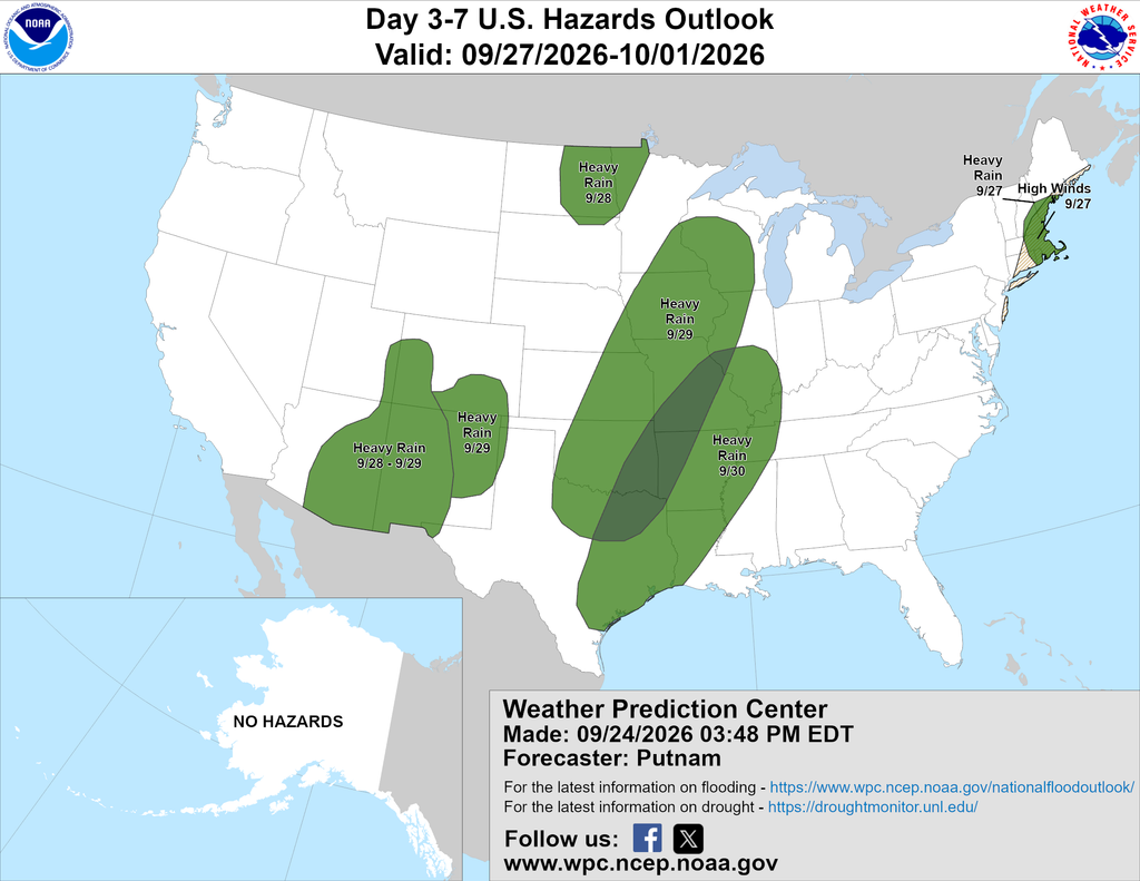
Attention will quickly turn toward Tuesday as a stronger storm system approaches the central United States. Forecast guidance shows a deep upper-level trough moving toward the Plains while strong southerly flow transports unusually rich moisture northward into Iowa. Atmospheric moisture levels could become very high for late September, creating an environment capable of producing efficient rainfall. Widespread rain and thunderstorms are increasingly likely sometime from Monday night into Tuesday, with precipitation potentially continuing into Wednesday. Some guidance supports another one to two inches of rain where the strongest moisture transport and repeated thunderstorms develop. Confidence is high that Iowa will see another period of wet weather, but confidence is lower regarding exactly where the heaviest rain falls and how long precipitation continues.
One complicating factor is a potential connection to tropical moisture originating from the eastern Pacific. That additional moisture could feed into the larger storm system moving across the Plains and Midwest, increasing the amount of water available for rainfall. Forecast models disagree on how quickly the upper-level system moves east, and that difference will become very important for Iowa’s weather next week. A faster-moving system would shorten the period of rain, while a slower or partially cut-off storm could produce multiple rounds of precipitation into the middle or latter part of the week. The slower scenario would create greater concern for heavy rainfall because it would allow rain to repeatedly fall over already-wet ground. This remains several days away, so rainfall totals and timing should be viewed as trends rather than precise predictions.
Thunderstorms Possible Tuesday, but Severe Weather Details Remain Uncertain
Thunderstorms will also be possible with the early-week system, particularly as a cold front approaches Iowa. Unlike the weekend system, the atmosphere may contain more instability and wind shear by Tuesday, which could create an environment more supportive of stronger thunderstorms. At this point, however, there is not enough confidence in the timing or placement of those ingredients to define a meaningful severe weather threat for Iowa. The exact track of the storm, timing of the front and amount of instability that develops will all influence whether stronger storms can form. Heavy rainfall currently stands out as the more consistent signal among the available forecast guidance. Severe weather trends will need to be reassessed as higher-resolution forecast models begin covering the event.
The amount of cloud cover and ongoing rain ahead of the front will also play an important role in determining thunderstorm intensity. If widespread rain limits daytime heating, instability could remain weak and reduce the potential for stronger storms. If breaks in the clouds develop and temperatures climb, the atmosphere could become more unstable before the front arrives. Those smaller-scale details are difficult to forecast several days in advance and explain why confidence in the severe weather portion of the forecast remains lower. Iowa residents should therefore pay attention to forecast updates over the weekend rather than focusing on a specific severe weather scenario this early. There is no indication from the current information that the weekend rain event will produce severe thunderstorms.
Stay with IowaWeather.com throughout the weekend for the latest local weather updates, rainfall forecasts and changes to next week’s storm system. Forecast confidence will improve as we get closer to Tuesday, particularly regarding the location of the heaviest rain and any thunderstorm threat across Iowa.