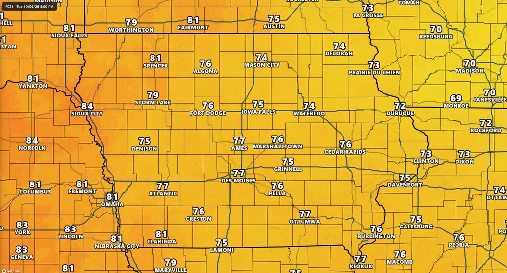
October continues to feel more like late summer across Iowa, and Tuesday will bring another warm day with plenty of sunshine and temperatures climbing well above what is typical for early October. Highs will reach the upper 70s to around 80 degrees across much of the state, with some locations in western and northwestern Iowa potentially reaching the lower 80s. The warmth will be accompanied by a noticeable breeze, particularly during the morning and afternoon hours. Despite a weak cold front crossing the state, rain is not expected today because the atmosphere remains too dry to support showers or thunderstorms.
The broader Iowa weather forecast remains quiet for most of this week. Wednesday will be another mild and dry day, followed by only a small opportunity for showers or a thunderstorm Thursday night into Friday morning. The weekend then appears likely to turn warmer again, with widespread upper 70s and potentially lower 80s returning to Iowa. A more meaningful change in the weather pattern may finally develop next week, but the timing and details remain uncertain this far out.
Warm October Weather Continues Across Iowa Today
Tuesday’s temperature forecast will once again run well above average across Iowa, with afternoon highs generally reaching the upper 70s to around 80 degrees. Western and northwestern Iowa have the best opportunity to reach the lower 80s, while much of eastern Iowa should remain in the middle to upper 70s. These temperatures are roughly 10 to 15 degrees above normal in portions of northern and western Iowa for this point in October. Sunshine will help temperatures rise quickly through the morning as warmer air remains in place ahead of a weak front moving across the state. Humidity should remain relatively comfortable despite some increase in moisture over parts of central and southern Iowa. Confidence is high that Tuesday will remain warm and dry statewide.
For anyone checking the weather today for outdoor plans, rain should not be a concern. The front crossing Iowa has very little moisture or atmospheric lift available to produce precipitation, so it will mainly be noticeable through changing wind direction. Temperatures may vary by a few degrees depending on exactly when the boundary reaches each location, but the overall result remains the same: another unusually warm October afternoon. Even behind the boundary, there is no significant push of cold air immediately following it. That will allow mild temperatures to continue into Wednesday. The current weather pattern is behaving much more like an extension of early fall than a transition toward colder late-fall conditions.
Breezy Winds Develop Tuesday
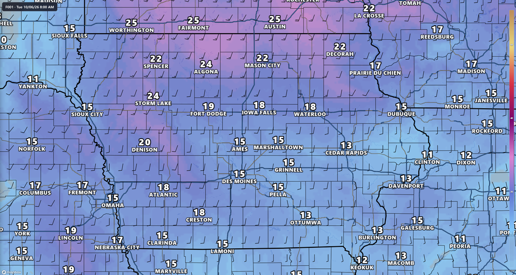
Wind will be one of the more noticeable parts of Iowa’s weather today as stronger winds just above the surface mix downward after sunrise. Gusts around 20 to 25 mph are possible across portions of the state, with the strongest winds generally favored across western and northern Iowa. Some areas near the Minnesota border could experience locally stronger gusts, while eastern and southern Iowa should see somewhat lighter winds. The breeze will continue into the afternoon before gradually easing as the front moves through and the pressure difference across the region weakens. Winds will also shift as the boundary passes, eventually becoming more northwesterly in many areas. No widespread damaging wind or high wind conditions are expected.
The combination of warm temperatures, dry air and gusty winds could also gradually dry grasses and other vegetation, particularly across northwest Iowa. Fire weather concerns are not expected to become widespread or extreme, but locally dry vegetation could burn more easily during the warmest and breeziest part of the day. This is especially worth watching in areas that have had enough time for grasses and crop residue to dry. Relative humidity is not expected to become exceptionally low across most of Iowa, which should limit the overall fire threat. Winds should become considerably lighter by Wednesday as high pressure settles into the region. Confidence in today’s wind forecast is high.
Patchy Fog Possible Wednesday Morning
A quieter atmosphere will settle over Iowa tonight into Wednesday morning as winds become light behind the departing front. Mostly clear skies and calm winds could allow temperatures near the ground to cool enough for localized fog to form before sunrise Wednesday. River valleys and other low-lying areas would be the most likely places to experience reduced visibility. This does not appear to be a widespread dense fog setup, and many locations may remain completely clear. Drivers traveling early Wednesday should still be prepared for rapidly changing visibility in isolated areas, particularly near rivers and other moisture-rich locations. Any fog that develops should improve after sunrise as temperatures rise.
Wednesday itself looks dry and mild across Iowa. Afternoon highs should generally reach the 70s, with the warmest temperatures in southern Iowa potentially climbing into the upper 70s or around 80 degrees. Northern and northeastern Iowa will be somewhat cooler behind the front, where temperatures could remain closer to the upper 60s and lower 70s. Some high clouds may also filter across portions of the state and slightly limit daytime warming. Winds will be considerably lighter than Tuesday, making Wednesday another favorable day for outdoor activities. Confidence is high in a dry forecast through Wednesday.
Small Rain Chance Returns Thursday Night
The first opportunity for measurable rain this week arrives Thursday night into early Friday, but this is not shaping up to be a significant rain event. A warm front will begin moving north as moisture attempts to return to Iowa, potentially allowing scattered showers or an isolated thunderstorm to develop. Current rain chances are generally around 20 to 30 percent, although the exact probability varies across the state and between forecast guidance. Northern and western Iowa may see some of the better opportunities initially, while at least a small chance could extend into central and eastern Iowa overnight. Dry air near the surface remains a major limiting factor, meaning some precipitation could develop above the ground without producing much measurable rain. Anyone looking at the rain forecast for late this week should view Thursday night as a chance rather than an expectation.
There is also disagreement among the major forecast models about how much moisture will actually return. Some guidance is more aggressive in generating measurable rainfall, while other solutions remain considerably drier. Even the wetter scenarios currently suggest that rainfall amounts would generally be light rather than widespread or heavy. There is enough instability for an isolated thunderstorm to be possible, but there is currently no strong signal for severe weather. The lack of deep moisture and stronger atmospheric forcing should keep the overall thunderstorm potential limited. Forecast confidence for Thursday night is moderate to low and will improve as the system gets closer.
Warmer Weather Builds Back for the Weekend
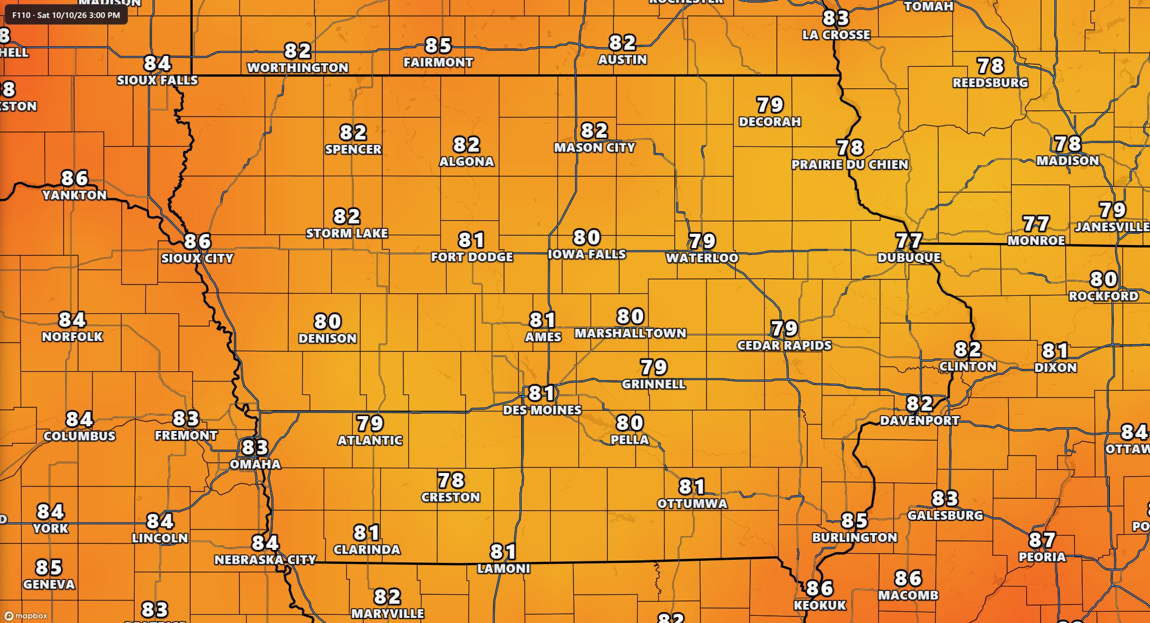
Anyone making weekend plans should continue to expect unusually mild October weather across Iowa. A ridge of higher pressure in the upper atmosphere will build across the Midwest as a larger storm system develops over the western United States. This pattern will encourage southerly winds to return, bringing warmer air north into Iowa. High temperatures should climb into the upper 70s across much of the state, with lower 80s increasingly possible in some locations. Eastern and northeastern Iowa may initially be slightly cooler, but temperatures there should also trend upward through the weekend. Overall confidence is fairly high that temperatures will remain above average.
Rain chances also appear quite limited through most of the weekend. Saturday currently favors dry weather across Iowa, and much of Sunday may remain dry as well. Breezy conditions could return as the pressure difference strengthens between the western storm system and high pressure farther east. That combination of warmth, wind and continued dry weather will need to be watched for potential localized fire weather concerns where vegetation has dried sufficiently. For most Iowans, however, the weekend forecast currently favors good conditions for outdoor events and fall activities. Changes become more likely toward Sunday night and early next week as the western storm system begins moving closer.
Looking Ahead: Wetter Pattern May Return Next Week
The extended weather forecast becomes more interesting late in the weekend and early next week as a large upper-level storm system moves out of the western United States. As that system approaches the Plains, winds higher in the atmosphere will turn more southwesterly across Iowa and begin transporting deeper moisture northward. This could eventually produce a more organized opportunity for rain and thunderstorms than anything expected during the remainder of this week. Several sets of longer-range model guidance support increasing precipitation chances, particularly from late Sunday into Monday and Tuesday. There is still considerable uncertainty regarding the exact track, strength and timing of the system, so it is too early to determine rainfall amounts or thunderstorm impacts. Confidence is higher in a pattern change occurring than in the specific details of what that change will bring to Iowa.
The main story through the next several days remains the persistent warmth. Iowa will see temperatures above normal much of this week, a brief and limited rain opportunity Thursday night into Friday, and another push of warmer air for the weekend. There is no meaningful cold outbreak showing up in the short-term forecast, and frost or freeze conditions are not expected to be a concern during this period. The more substantial opportunity for changing weather arrives next week as the western storm system moves toward the central United States. The timing of that system will become clearer over the next several days as newer forecast guidance becomes available. For now, residents can expect an extended stretch of mild October weather with relatively few interruptions.
Stay with IowaWeather.com for the latest Iowa weather forecast, changing rain chances and updates as the potential storm system for next week comes into better focus.