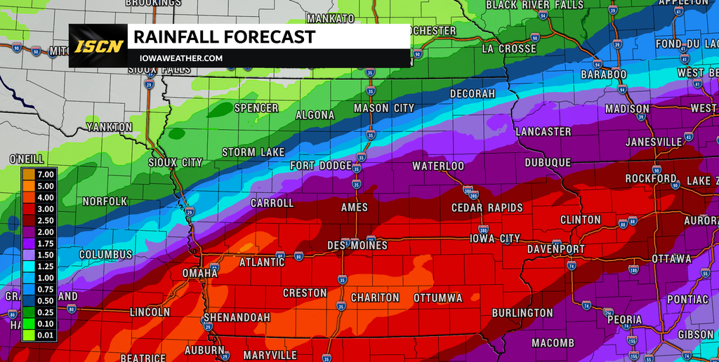
A prolonged stretch of wet weather is underway across Iowa, and the biggest concern over the next 48 hours will be heavy rainfall and flooding. Several rounds of rain and thunderstorms will cross the state through Thursday as an unusually moisture-rich storm system moves through the central United States. Many locations could receive 2 to 4 inches of rain, while locally higher totals are possible where thunderstorms repeatedly track over the same areas.
The setup is particularly concerning because much of Iowa has already received substantial rainfall this month, leaving the ground increasingly saturated. Tropical moisture associated with the remnants of former Hurricane Polo is being pulled northward and will interact with a slow-moving frontal boundary across the region. This combination will create an efficient environment for producing heavy rain, especially Wednesday afternoon through early Thursday. The rain finally begins shutting down from northwest to southeast Thursday into early Friday, followed by a much cooler and drier start to October.
Widespread Heavy Rain Expected Across Iowa
Rain will become increasingly widespread across Iowa Tuesday night and continue in multiple rounds Wednesday and Thursday. Rather than raining at the same intensity continuously, periods of moderate to heavy rain will be mixed with lighter showers, drizzle and occasional breaks. The atmosphere will contain unusually high amounts of moisture for late September, allowing showers and thunderstorms to produce significant rainfall even without widespread severe storms. Much of western, central and eastern Iowa has the potential to receive 2 to 4 inches of rain, with locally higher totals possible where thunderstorms repeatedly move across the same locations. Northwest Iowa should generally see lower totals, with a sharp rainfall gradient possible as the main storm track remains farther south.
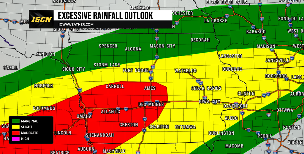
Confidence is high that a large portion of Iowa will receive substantial rainfall, but exactly where the highest totals develop remains less certain. Small changes in the position of the stalled frontal boundary could shift the corridor of heaviest rain north or south. Current trends favor the most significant rainfall near and south of the Interstate 80 corridor in western and central Iowa before the heavier rain expands farther east. Parts of northeast Iowa could also receive more than 2 inches, especially where multiple rounds overlap. Anyone checking the rain forecast or weather forecast for tomorrow should expect Wednesday to be a very wet day across much of Iowa.
Flooding and Flash Flooding Are the Primary Concern
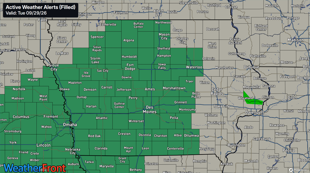
Flooding is the most significant weather hazard with this system, particularly Wednesday into Thursday. Flood Watches cover a large portion of Iowa as repeated rainfall falls on increasingly saturated ground. Excessive runoff could cause creeks and streams to rise quickly, while urban areas, poor-drainage locations and low-lying roads could experience standing or flowing water. River levels are also expected to rise following the rain, meaning some river flooding could continue after the heaviest precipitation has ended. The flooding threat will increase considerably in any location that receives repeated thunderstorms with higher rainfall rates.
The greatest concern comes Wednesday afternoon through Wednesday night, when thunderstorms could become efficient rain producers across western and central Iowa. The strongest storms may produce rainfall rates of 1 to 2 inches per hour, and repeated storms moving over the same area could quickly overwhelm drainage systems. Forecast guidance supports widespread totals of 2 to 4 inches, but localized amounts approaching 5 to 6 inches cannot be ruled out where the heaviest bands persist. That does not mean every community will receive that much rain, and there may be substantial differences over relatively short distances. Confidence in a flooding threat is high, while confidence in exactly where the highest localized totals occur is lower.
When Will the Heaviest Rain Fall?
The first widespread round of rain will continue developing Tuesday night and persist into Wednesday morning, with some of the more organized rainfall occurring overnight into the morning commute. Eastern Iowa is likely to see rain become widespread by Wednesday morning, including areas around Cedar Rapids, Waterloo, Dubuque and the Quad Cities. Farther west, another surge of heavier showers and thunderstorms is expected to develop Wednesday afternoon and spread northeast into Iowa Wednesday evening. This second period could become particularly important for western and central Iowa because it will arrive after the ground has already absorbed substantial rainfall. Additional rain will continue Wednesday night into Thursday morning before gradually shifting east and southeast.
Eastern and southeastern Iowa may experience another round of heavier rain later Thursday before the entire system finally departs. The exact placement of this final band remains less certain, and recent trends have favored a track farther south and east. Areas from southeast Iowa into western Illinois may therefore have the longest wait before rain completely ends. Northwest Iowa should dry out considerably sooner, with improving conditions beginning Thursday. For much of the state, Friday should finally bring a return to dry weather.
Remnants of Hurricane Polo Adding Tropical Moisture
One reason this system can produce so much rain is its connection to tropical moisture from the remnants of former Hurricane Polo. The circulation associated with Polo is being absorbed into a larger upper-level storm system moving from the Southwest toward the central Plains. At the same time, additional moisture is being transported north from the Gulf, creating an exceptionally moisture-rich atmosphere over the region. Atmospheric moisture measurements are forecast to reach levels near the upper end of what is typically observed in Iowa during late September. That abundant moisture will allow showers and thunderstorms to produce rain very efficiently.
This does not mean a hurricane or tropical storm is moving into Iowa. Instead, moisture that was once associated with Polo is becoming incorporated into a much larger weather system over the central United States. A slow-moving frontal boundary will then provide a focus for repeated rain and thunderstorm development. Because the boundary will not move quickly, some locations may experience several rounds of rainfall before the system finally moves east. This combination of tropical moisture, a stalled boundary and repeated storms is why the flooding potential is greater than with a typical fall rain event.
Des Moines Could Challenge Its Wettest September on Record
The final day of September could add another remarkable chapter to an already exceptionally wet month in Des Moines. Through Tuesday afternoon, Des Moines had recorded 13.05 inches of precipitation during September, putting the city within striking distance of its wettest September on record. The existing September record is 14.81 inches, meaning another 1.76 inches would tie that mark. With multiple rounds of heavy rain expected before September officially ends at midnight Wednesday night, the record is within reach. Exactly how much rain falls before midnight will determine whether September 2026 moves to the top of the record book.
There is also a possibility that the month could move higher among the wettest months of any time of year in Des Moines, depending on the final rainfall total. The ongoing wet pattern is important beyond the record books because it means additional rain will increasingly run off rather than soak efficiently into the ground. That raises concerns for creeks, streams, rivers and low-lying areas during the upcoming rounds of rainfall. Additional rainfall totals will need to be monitored closely throughout Wednesday. IowaWeather.com will continue tracking the final September rainfall numbers as observations come in.
Cooler Fall Weather Arrives Behind the Rain
A noticeable change in the weather pattern will arrive once the storm system moves east. Cooler and much drier air will spread into Iowa behind a cold front, bringing a more traditional early October feel beginning Thursday in northwest Iowa and statewide by Friday. Afternoon temperatures Friday should generally remain in the 60s, considerably cooler than the warmer conditions experienced ahead of the system. Overnight temperatures will also fall, with many locations dropping into the 40s as skies clear and drier air settles over the region. The cooler weather should continue through much of the weekend.
Most of Iowa should remain dry Friday and through much of the weekend as high pressure takes control. A weak disturbance may bring a small chance of showers to far northern Iowa or areas farther north Saturday night into Sunday, but widespread rainfall is not currently expected. This dry stretch will be welcome for agricultural operations and communities dealing with the effects of this week’s rain. Temperatures should remain seasonable to slightly cool into early next week. Forecast confidence is relatively high in the transition toward cooler and predominantly dry weather.
Stay with IowaWeather.com throughout Wednesday and Thursday as we track the latest Iowa weather forecast, rainfall totals, flooding concerns and changes in the storm track. With several rounds of rain still ahead, small changes in where the heaviest bands develop could make a significant difference in local rainfall totals and flooding impacts.