Funnel Clouds Possible Across Northern Iowa This Afternoon; One Reported Near Iowa Border
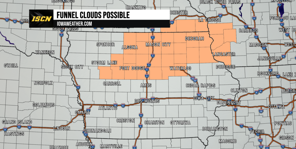
Residents across northern and northeastern Iowa may notice unusual cloud formations this afternoon as atmospheric conditions have become favorable for the development of brief funnel clouds.
The National Weather Service offices in Des Moines and La Crosse have both issued Special Weather Statements highlighting the potential for these weak, short-lived funnels.
Why Are Funnel Clouds Forming?
Today’s weather pattern features cool air aloft combined with light winds and pockets of daytime heating. This combination can occasionally produce cold-air funnel clouds, which are much different than the tornado-producing supercell thunderstorms many Iowans are familiar with.
These funnels typically:
- Remain suspended beneath the cloud base.
- Extend only a few hundred feet downward.
- Last just a few minutes.
- Rarely touch the ground.
- Almost never produce damage.
While they can look intimidating, the vast majority of these funnel clouds never become tornadoes.
Funnel Cloud Already Reported Near Iowa
The National Weather Service in La Crosse reports that a funnel cloud was observed near Sargeant, Minnesota, just north of the Iowa border early this afternoon.
Additional funnel clouds may develop through the afternoon across portions of:
- North Central Iowa
- Northern Iowa
- Northeast Iowa
- Southeast Minnesota
- Western Wisconsin
Iowa Counties Included
The greatest chance for funnel cloud development includes communities such as:
- Mason City
- Clear Lake
- Forest City
- Algona
- Hampton
- Fort Dodge
- Webster City
- Waterloo
- Cedar Falls
- Decorah
- Waukon
- Charles City
- New Hampton
- Oelwein
- Elkader
Should You Be Concerned?
At this time, no damage is expected, and these funnel clouds are not associated with severe thunderstorms.
However, if you observe a funnel cloud:
- Continue to monitor its movement.
- If it begins descending toward the ground or debris begins swirling beneath it, move indoors immediately.
- Stay alert for any Tornado Warnings that may be issued if conditions change.
Stay Weather Aware
ISCN will continue to monitor conditions throughout the afternoon. If you safely capture photos or video of a funnel cloud, send them to ISCN through our Facebook page or the ISCN Weather App.
As always, we’ll provide updates immediately if any funnels strengthen or if warnings become necessary.