Iowa Flood Watch Issued for Central, Northern, and Northeast Iowa Through Thursday Morning
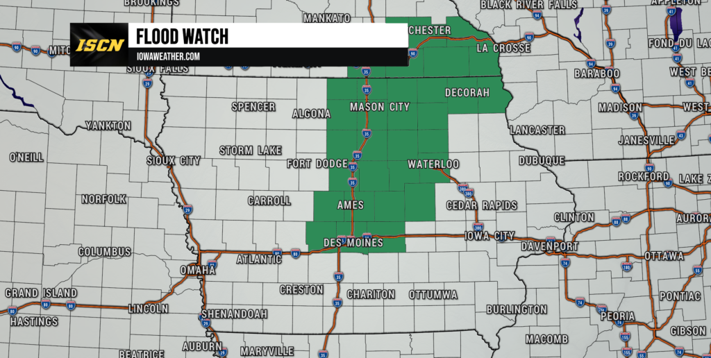
A Flood Watch has been issued for much of central, north central, and northeast Iowa through Thursday morning as another round of thunderstorms is expected to bring periods of heavy rainfall across the state. Some locations could receive 1 to 3 inches of rain, with isolated totals exceeding 4 inches, creating the potential for renewed flooding in areas that have already seen significant rainfall over the past several days.
Meteorologists with the National Weather Service say repeated thunderstorms moving over the same locations could quickly overwhelm drainage systems and cause rivers, creeks, and streams to rise out of their banks. With soils already saturated across portions of Iowa, it will take less rainfall than usual to produce flooding concerns.
Flood Watch Covers Nearly Two Dozen Iowa Counties
The Flood Watch stretches across a large portion of Iowa, including many communities throughout central, north central, and northeast Iowa. Cities included in the watch include Des Moines, Ames, Waukee, Adel, Newton, Marshalltown, Waterloo, Cedar Falls, Mason City, Webster City, Hampton, Clarion, Garner, Forest City, Charles City, New Hampton, Cresco, Decorah, Waukon, and numerous surrounding communities.
For most of central Iowa, the Flood Watch remains in effect through Thursday morning, while portions of northeast Iowa are under the watch until midnight tonight. The watch was issued because confidence continues to increase that multiple rounds of thunderstorms will develop this evening and overnight.
Multiple Rounds of Storms Could Produce Heavy Rainfall
The greatest concern with tonight’s storms is the potential for repeated rounds of heavy rain. Forecast models continue to indicate thunderstorms may track over the same locations, a setup commonly referred to as “training” storms. When this occurs, rainfall can quickly accumulate over a relatively small area, significantly increasing the risk of flash flooding.
Current forecast guidance suggests widespread rainfall amounts between 1 and 3 inches, with isolated pockets receiving more than 4 inches where thunderstorms repeatedly develop. Since many rivers and streams are already running above normal following recent rainfall, additional heavy rain could quickly lead to renewed flooding.
While the axis of the heaviest rainfall remains somewhat uncertain, confidence is increasing that portions of central and northern Iowa will experience periods of torrential rainfall this evening.
Damaging Winds Also Possible With Stronger Storms
Although flooding is expected to be the primary hazard, some thunderstorms could also become severe during the evening hours. The National Weather Service says the atmosphere will be capable of producing damaging wind gusts approaching 70 mph, particularly as clusters of thunderstorms organize and move southeast across the state.
Forecasters note that the overall tornado threat remains relatively low, and the risk for large hail appears limited. However, strong straight-line winds combined with torrential rainfall could lead to downed tree limbs, isolated power outages, and rapidly changing travel conditions.
Flooding Could Develop Quickly in Urban and Low-Lying Areas
Areas most susceptible to flooding include urban locations where storm drains can quickly become overwhelmed, as well as low-lying roads, small creeks, and poor drainage areas. Even locations that do not typically experience flooding could see water covering roads if thunderstorms repeatedly move across the same communities.
Drivers should remain especially cautious this evening and overnight. Floodwaters can rise much faster than many people expect, and just a small amount of moving water can sweep a vehicle off the roadway. If you encounter a flooded road, remember the phrase, “Turn Around, Don’t Drown.”
Stay Weather Aware Tonight
Residents across central, northern, and northeast Iowa should continue monitoring forecasts throughout the evening as thunderstorms develop. Additional Flood Warnings, Flash Flood Warnings, and Severe Thunderstorm Warnings may be issued if storms begin producing excessive rainfall or damaging winds.
The Iowa Storm Chasing Network will continue providing live radar updates, storm reports, and warning information throughout the event on IowaWeather.com, the ISCN Weather App, and across our social media platforms.