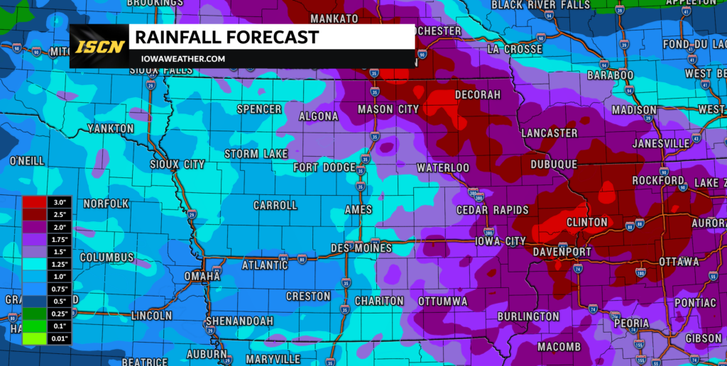
After several days of hot and dry weather, much of Iowa remains on track to receive a widespread soaking rain tonight through Friday. Forecast confidence has continued to increase that many communities will receive beneficial rainfall, although the exact location of the heaviest totals remains uncertain.
While a few showers and thunderstorms will continue to develop across western Iowa this afternoon, the main round of rain and thunderstorms is expected to spread across the state late tonight into Friday morning. Additional showers and thunderstorms may redevelop Friday afternoon before the system exits the state Friday night.
What to Expect
Forecast guidance continues to indicate that most of Iowa will receive 1 to 3 inches of rainfall, with localized higher amounts possible where thunderstorms repeatedly move across the same locations.
This rainfall will be welcome across many areas that have become increasingly dry during recent weeks. However, rainfall rates could become intense enough to produce localized flash flooding, particularly in urban areas, locations with poor drainage, and places that experience multiple rounds of thunderstorms.
The exact placement of the heaviest rainfall remains uncertain. Small shifts in the track of thunderstorms tonight could determine which communities receive several inches of rain while others receive significantly less.
Heavy Rain Is the Primary Concern
The overall weather pattern continues to favor efficient rainfall production.
Atmospheric moisture levels remain unusually high for late July, with precipitable water values near two inches across the region. Combined with slow-moving thunderstorms and the potential for storms to repeatedly track over the same areas, rainfall could accumulate quickly overnight.
While widespread river flooding is not expected, localized flash flooding remains a concern wherever storms train over the same location. Rainfall rates exceeding one to two inches per hour will be possible within the strongest thunderstorms.
If you encounter flooded roads overnight or Friday morning, remember to Turn Around, Don’t Drown. Water-covered roads can hide washed-out pavement and only a small amount of moving water is needed to sweep a vehicle away.
Severe Weather Threat Remains Limited
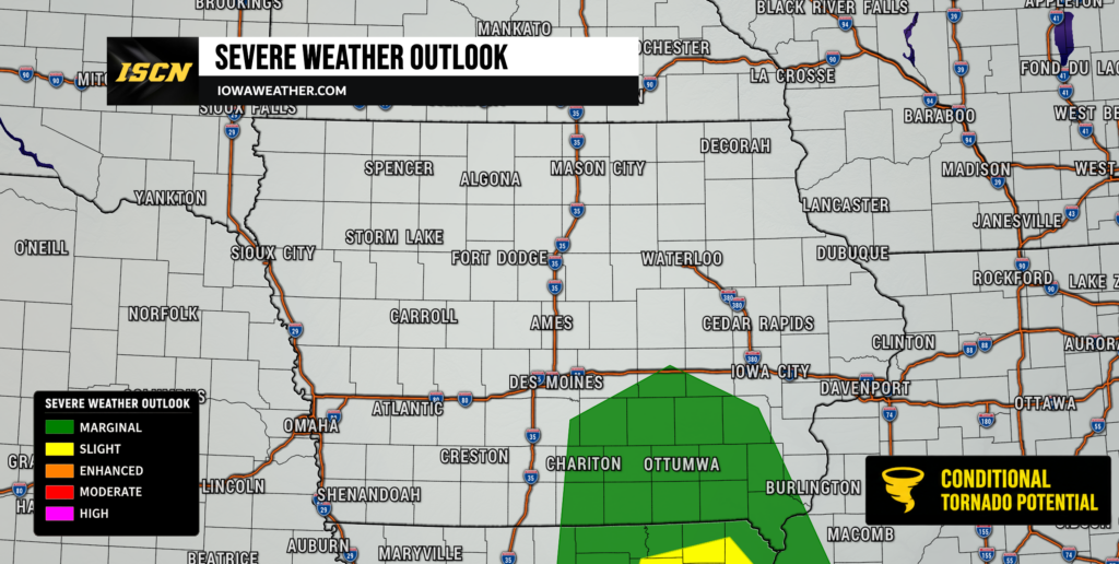
Although a few storms this afternoon and evening across western Iowa could produce gusty winds, the overall severe weather threat tonight remains relatively low as storms weaken while moving east across the state.
Attention then turns to Friday afternoon.
As the storm system moves across Iowa, there may be a break in the rainfall across portions of southern and southeastern Iowa. If enough sunshine develops behind the morning rain, the atmosphere could become unstable enough to support another round of thunderstorms.
At this time, southeast Iowa appears to have the greatest potential for isolated severe weather Friday afternoon into early evening. Damaging wind gusts would be the primary concern, although a brief tornado cannot be ruled out if enough instability develops. Confidence in this scenario remains conditional and will largely depend on how much sunshine develops after the morning rainfall.
Windy Conditions Develop Friday Afternoon
Even after the heaviest rainfall ends, conditions will remain active Friday.
As low pressure moves across the Midwest, northwest winds will increase significantly during the afternoon. Wind gusts of 40 to 45 mph are expected across portions of Iowa, making for a breezy end to the workweek.
Cooler, Quieter Weather Returns This Weekend
Once this storm system departs Friday night, Iowa will enjoy a much more comfortable stretch of weather.
High temperatures this weekend are expected to remain in the upper 70s to lower 80s with noticeably lower humidity. Dry conditions are expected to continue through at least Monday, providing a welcome break after tonight’s rain.
Stay Weather Aware
Although this rainfall will be beneficial for many areas, localized flooding can develop quickly where thunderstorms repeatedly move over the same locations.
Now is a good time to:
- Monitor the latest forecast through tonight and Friday.
- Be prepared for rapidly changing conditions if heavy rain develops in your area.
- Never drive across flooded roadways.
- Allow extra travel time Friday morning if you encounter areas of heavy rain.
The Iowa Storm Chasing Network will continue monitoring conditions throughout the event and will provide updates on rainfall totals, flooding concerns, and any strong or severe thunderstorms that develop across the state.