After a stretch of active weather, Iowa is settling into a much quieter pattern to begin the new week. High pressure moving across the Midwest is bringing comfortable temperatures, lower humidity, and mostly sunny skies through Monday. While some high-level wildfire smoke will continue drifting overhead, it will remain well above the ground and primarily create a milky or hazy appearance in the sky rather than affecting day-to-day activities for most people.
The calm weather won’t last all week. A cold front arriving from the northern Plains will bring increasing chances for showers and thunderstorms beginning Tuesday and continuing into Wednesday. While not everyone will experience severe weather, some storms could produce strong winds, hail, and locally heavy rainfall. Many areas of Iowa could also receive much-needed rain as drought concerns continue in parts of the state.
Enjoy the Quiet Weather Through Monday
Sunday and Monday will be excellent days for outdoor activities across much of Iowa. Afternoon temperatures will climb into the lower and middle 80s, which is very close to what is typical for early August. Humidity levels will remain comfortable compared to recent weeks thanks to a relatively dry air mass settling over the region. Sunshine will dominate both days, although the sky may appear somewhat hazy because of wildfire smoke high in the atmosphere. Winds will generally remain light before gradually turning southerly Monday as the next weather system begins approaching from the northern Plains.
Patchy Morning Fog Possible Monday
Some communities could wake up to areas of patchy fog early Monday morning. The best chance will be in low-lying locations, river valleys, and other areas that cool efficiently overnight, although widespread dense fog is not expected. Any fog that develops should quickly improve after sunrise as temperatures warm and light mixing begins. Travelers heading out early Monday should remain alert for locally reduced visibility, especially on rural roads. Confidence in widespread travel impacts remains low, but a few isolated locations may briefly experience visibility below one mile.
Wildfire Smoke Will Continue to Create Hazy Skies
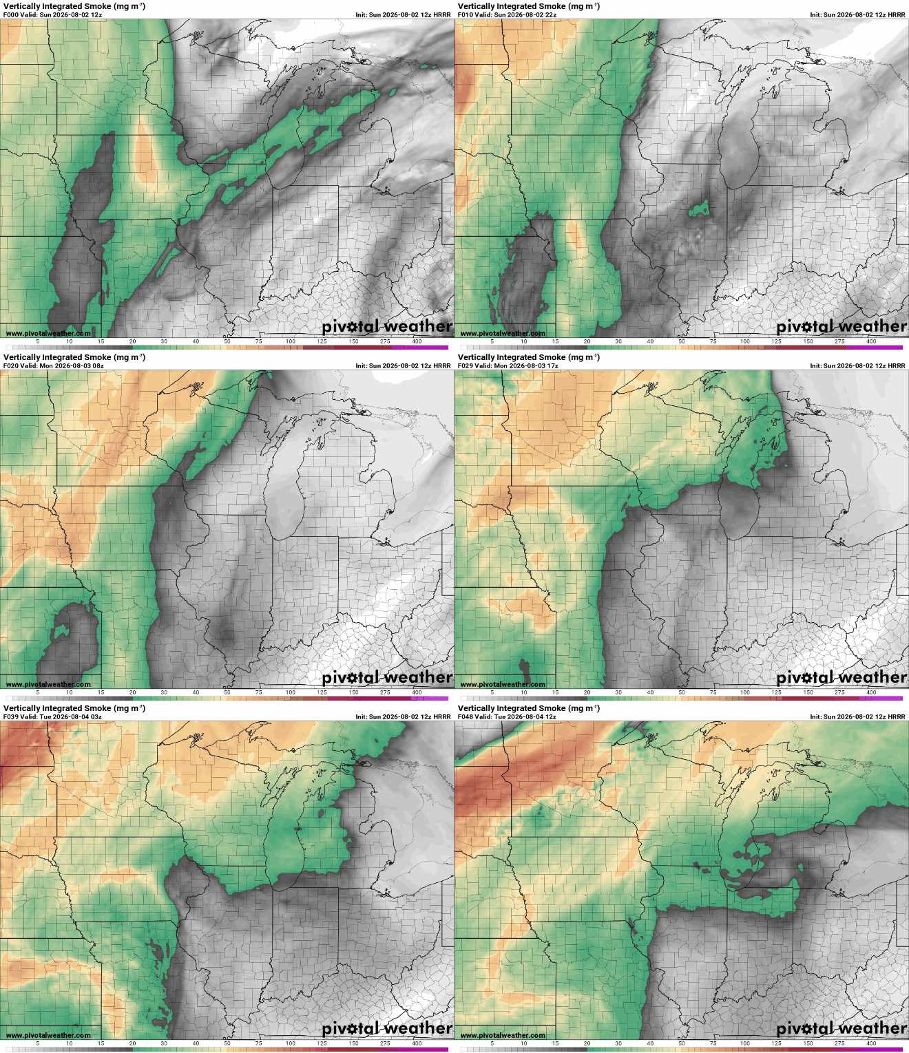
Canadian wildfire smoke will remain overhead through at least Monday and may linger into early Tuesday. The smoke is expected to stay primarily in the upper levels of the atmosphere, meaning most Iowans should notice hazy sunshine or colorful sunrises and sunsets rather than poor air quality at ground level. Although the smoke can slightly reduce the intensity of the sunshine, temperatures are still expected to reach the lower and middle 80s each afternoon. Those particularly sensitive to airborne particles should continue monitoring local air quality forecasts, but widespread health concerns are not anticipated at this time. Overall confidence is high that the smoke remains elevated rather than mixing significantly to the surface.
Storm Chances Return Tuesday as a Cold Front Arrives
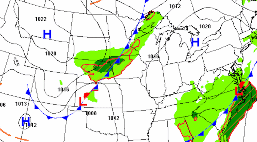
The weather pattern begins changing Tuesday as a cold front moves southeast into Iowa. Southerly winds ahead of the front will transport increasing moisture back into the state, allowing humidity levels to climb after a relatively comfortable start to the week. Showers and thunderstorms are expected to become more widespread from northwest Iowa into central and eastern Iowa during Tuesday and continue into Tuesday night. Not every community will receive rain immediately, but most of the state has a good opportunity to see measurable precipitation before the system moves through. Forecast confidence is high that rain returns, although the exact timing for individual cities may still shift by several hours.
A Few Strong to Severe Storms Are Possible
While widespread severe weather does not appear likely at this time, a few thunderstorms Tuesday afternoon and evening could become strong. The greatest concern currently appears to be damaging wind gusts and pockets of large hail where storms become better organized. Tornado potential currently looks limited because the strongest wind shear is expected to trail behind the advancing cold front and storm bases may remain relatively high. Exactly where stronger storms develop will depend on how quickly instability builds during the day and whether storms can overcome a layer of warm air aloft that may initially suppress development. Confidence is moderate that isolated severe storms occur somewhere in or near Iowa, but confidence remains lower regarding exactly which counties will experience the strongest storms.
Heavy Rain Could Bring Welcome Moisture
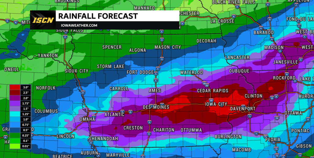
One of the biggest benefits of this upcoming system may be the potential for widespread rainfall. Atmospheric moisture levels will increase considerably ahead of the cold front, allowing thunderstorms to produce efficient rainfall rates. Some locations, especially across northern Iowa, could experience repeated rounds of storms moving over the same areas, increasing the possibility of locally heavy rainfall totals. While widespread flooding is not currently expected, isolated flooding issues could develop where storms repeatedly track across the same communities. For many areas dealing with dry conditions, this rainfall would provide much-needed moisture for crops, lawns, and gardens.
Cooler Temperatures Settle In Midweek
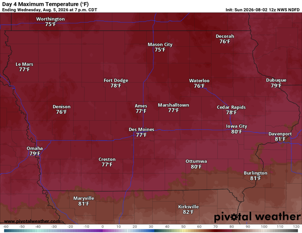
Behind the cold front, noticeably cooler air will spread across Iowa during the middle of the week. High temperatures Wednesday will likely remain in the 70s across much of the state, offering a refreshing break from typical August warmth. Additional scattered showers and thunderstorms may linger Wednesday as the frontal boundary slows or briefly stalls near southern Iowa. Cloud cover and periods of rain will help keep temperatures below average before gradual warming begins later in the week. Confidence is fairly high that Wednesday will be one of the coolest days Iowa has experienced in several weeks.
Looking Ahead
The active weather pattern may not end immediately after Wednesday. Forecast models suggest Iowa could remain under northwest flow aloft, allowing additional weak disturbances to move through later in the week. While confidence decreases beyond Thursday, temperatures are expected to gradually rebound into the 80s as southerly winds return. Additional opportunities for showers and thunderstorms may develop next weekend, although the exact timing and coverage remain uncertain this far out. Iowa residents should enjoy the pleasant weather early this week while preparing for a wetter and more active pattern beginning Tuesday.
Stay with IowaWeather.com for the latest Iowa weather forecast, weather radar, severe weather updates, rainfall forecasts, and live storm coverage as this week’s changing weather pattern unfolds across the state.