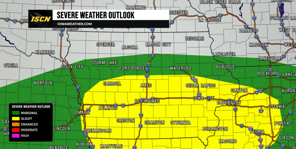
Friday afternoon is shaping up to be another active weather period across Iowa as the atmosphere attempts to recover from this morning’s storms and widespread cloud cover. A compact disturbance moving east from Nebraska will provide the trigger for another round of thunderstorms later this afternoon and evening, especially across central and southern Iowa. Damaging winds appear to be the most common severe weather threat, but a few storms could also produce hail and a tornado or two. At the same time, exceptionally high atmospheric moisture combined with saturated ground will create a serious concern for additional flash flooding.
The biggest question for the severe weather forecast is how much sunshine and warming Iowa can achieve before storms redevelop. Clouds have lingered over much of the state, and that could limit instability enough to reduce the overall severe threat in some areas. However, where temperatures are able to climb and the atmosphere becomes unstable, conditions will support organized thunderstorms capable of producing severe weather. Heavy rainfall is a concern regardless, particularly across central and southern Iowa where several rounds of rain have already fallen this week. Iowa residents should continue checking the latest weather radar and weather alerts through the evening as storms develop and move east.
Severe Weather Threat Increases Late Friday Afternoon
The greatest potential for severe thunderstorms will develop during the late afternoon and continue through the evening across portions of central and southern Iowa. A rotating disturbance known as a mesoscale convective vortex, or MCV, is moving east from Nebraska and will provide additional lift and stronger winds above the surface as it crosses the state. If enough instability develops ahead of this feature, thunderstorms may quickly become organized as they form over western and central Iowa. The most favored corridor currently appears to include parts of central Iowa and areas near Interstate 80, although the exact placement will depend heavily on how the atmosphere recovers from earlier storms. The Storm Prediction Center maintains a Slight Risk, Level 2 of 5, across parts of Iowa, signaling that scattered severe storms are possible rather than a widespread outbreak. Confidence in thunderstorms developing is relatively high, but confidence in exactly how intense they become remains more moderate because of persistent cloud cover.
The atmosphere contains plenty of moisture and roughly 30 to 40 knots of wind shear, which describes how wind speed and direction change with height. That combination is enough to support organized thunderstorms if storms can tap into surface-based instability approaching 1,000 to 2,000 joules per kilogram or higher. Some storms could initially develop as discrete or semi-discrete cells before eventually merging into larger clusters or bowing segments. Severe thunderstorm warnings may be needed quickly where stronger storms mature, so people with outdoor plans should keep a reliable weather app or another source of weather alerts nearby. The severe weather threat should gradually move from west to east through the evening and generally diminish across central Iowa by late evening. Eastern Iowa could remain at risk later into the evening and overnight as storms continue toward the Mississippi River.
When Will Storms Arrive in Iowa?
Thunderstorms are expected to redevelop first across portions of western Iowa during the mid to late afternoon as the disturbance from eastern Nebraska moves into the state. Activity should then spread into central Iowa during the late afternoon and early evening, potentially including the Des Moines and Ames areas during the evening commute and early nighttime hours. Current forecast guidance favors the most organized storms progressing generally eastward between roughly Interstate 80 and Highway 30, but storms could develop south of that corridor as well. Timing remains somewhat uncertain because recent high-moisture weather patterns have been difficult for short-range weather models to handle precisely. Small differences in cloud cover, temperature and the location of leftover boundaries can shift storm development by dozens of miles or by an hour or two. Anyone traveling across Iowa late Friday should therefore rely on live weather radar rather than a single forecast arrival time.
Storms should continue advancing into eastern Iowa during the evening, with another cluster or larger thunderstorm complex potentially affecting areas toward the Mississippi River later tonight. Parts of eastern Iowa could see thunderstorms continue well after sunset, particularly if storms consolidate into a larger complex. Farther north, including portions of northwest and northeast Iowa, storm coverage should generally be more scattered and the severe threat lower. The heaviest rain axis has also continued trending farther south compared with earlier forecasts, placing central and southern Iowa in the more concerning corridor. Most storms should gradually move east of central Iowa between roughly 10 p.m. and 1 a.m., although showers and poor travel conditions may linger longer. Conditions should improve from west to east overnight before another chance for scattered storms develops Saturday.
Damaging Winds Are the Primary Severe Weather Hazard
Damaging wind gusts are expected to be the most widespread severe weather concern with Friday afternoon and evening thunderstorms. The atmosphere is extremely moist, allowing thunderstorms to become heavily loaded with rain before strong downdrafts push that air toward the ground. These wet downbursts can produce sudden bursts of damaging wind capable of bringing down tree limbs and causing localized power outages. If individual storms merge into bowing line segments, the wind threat could increase along the leading edge of those clusters. Areas of central and southern Iowa appear to have the best overlap of instability, wind shear and storm coverage for this threat. Even storms that do not become formally severe could produce strong wind gusts and extremely heavy rainfall.
Large hail is also possible, although the hail threat is somewhat lower than the damaging wind threat because temperatures in the middle levels of the atmosphere are not especially favorable for very large hail growth. Stronger storms that remain more isolated could still produce hail for a time before becoming more rain-dominant. The environment favors what meteorologists often call high-precipitation thunderstorms, meaning storms may contain intense rain that can obscure wind or tornado hazards. That is especially important for drivers, since visibility can drop quickly beneath the strongest thunderstorms. Severe weather can change rapidly in this kind of environment, so do not rely only on what the sky looks like from your location. Monitor local weather radar and warnings as storms approach.
A Tornado or Two Is Possible
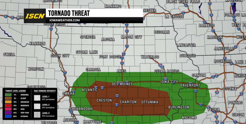
The tornado threat has increased somewhat for portions of Iowa Friday afternoon and evening, although tornadoes are still expected to be isolated rather than widespread. The latest convective outlook includes a 5% tornado probability across part of the state, reflecting an environment that could support a tornado or two if stronger surface-based thunderstorms develop. Winds near the ground are expected to turn with height, creating enough low-level rotation for some storms to acquire rotating updrafts. The approaching MCV may also enhance local rotation within the atmosphere, particularly close to boundaries left behind by previous thunderstorms. Central Iowa and areas near or south of Interstate 80 warrant particularly close attention if storms can become established during peak heating. The overall tornado threat will decrease considerably if thick cloud cover prevents the atmosphere from becoming sufficiently unstable.
This is a conditional tornado setup, meaning the ingredients are present but storms still need to develop in the right place and at the right time to fully use them. A storm interacting with a warm front or other leftover boundary could briefly encounter stronger low-level wind shear than surrounding storms. That makes the exact position of those boundaries important and also adds uncertainty to the forecast. Tornadoes embedded within rain-heavy storms can be particularly difficult to see, especially later in the evening as daylight fades. If a tornado warning is issued, move to a basement or small interior room on the lowest floor and do not wait for visual confirmation. Continue following updated weather alerts because small shifts in storm development could change which communities experience the greatest tornado risk.
Flash Flooding Could Become the Most Significant Impact
While severe storms will receive much of the attention Friday evening, flash flooding may ultimately become the more widespread and significant weather hazard. Much of Iowa has experienced repeated rounds of heavy rain during the past several days, leaving soils saturated and reducing the amount of additional rainfall the ground can absorb. Atmospheric moisture is exceptionally high, with precipitable water values near or above 2 inches across much of the state and locally approaching 2.4 inches. Those values are near the extreme end of what is typical for Iowa in August and will allow thunderstorms to produce torrential rainfall. Rainfall rates of 2 to 3 inches per hour are possible beneath the strongest storms, especially across western, central and southern Iowa. Even a relatively short period of heavy rain could produce rapid ponding, road flooding and rises on small streams.
The Weather Prediction Center maintains a Moderate Risk for excessive rainfall across a large part of central and southern Iowa, indicating a substantial risk for scattered to numerous instances of flash flooding. The corridor of greatest concern extends roughly from Highway 30 south toward Highway 92, including the Ames and Des Moines metropolitan areas and many smaller communities in between. Some portions of eastern Iowa have already received 4 to 6 inches of rain during recent storm rounds, making additional rainfall especially problematic there as storms move east tonight. Thunderstorms may repeatedly move over the same areas or redevelop along the back side of a larger complex, a process known as training. That could produce localized rainfall totals considerably higher than surrounding locations even if storms eventually begin moving more quickly. Drivers should never attempt to cross a flooded road because water depth and road damage are often impossible to judge at night.
River and Creek Levels Could Rise Quickly
Flooding concerns will extend beyond streets and low-lying areas because streams, creeks and rivers are already responding to several days of heavy rainfall. Moderate to significant rises are expected on numerous waterways through Saturday, and isolated minor river flooding is possible. Several rivers could approach flood stage depending on exactly where Friday evening’s heaviest rain falls. Smaller waterways such as Ioway Creek near Ames and Walnut and Fourmile Creeks around Des Moines may respond much more quickly than larger rivers during intense rainfall. Urban drainage systems will also struggle if thunderstorms produce several inches of rain in a short period. Residents near creeks or flood-prone areas should remain alert even after thunderstorms have moved away because water levels can continue rising afterward.
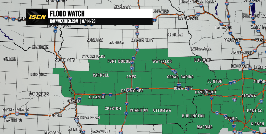
There is also a meaningful risk that river flooding could become more substantial if rainfall exceeds the current forecast. An additional half-inch to one inch above expected totals across a river basin could be enough to produce more widespread minor flooding and potentially several moderate flood crests. Exactly where that happens cannot be determined until the heaviest rainfall axis becomes clearer this evening. The repeated storm pattern makes antecedent conditions, or how wet the ground was before the newest storms arrived, especially important in determining flood severity. Flood watches remain in effect across a large portion of the state through Saturday morning because of this cumulative rainfall threat. Anyone living near a river, creek or known flood-prone location should continue checking updated river levels and local weather information overnight.
More Storms Possible Saturday, But Coverage Should Be Lower
Saturday will not be completely dry, although thunderstorm coverage should be more scattered than Friday. Another disturbance will move through Iowa during the day while a cold front gradually advances toward the state. Spotty showers and thunderstorms could develop during the morning, followed by another opportunity for scattered storms during the afternoon and evening. Current guidance suggests the storms will be less widespread, which should provide many areas with meaningful breaks from the recent near-daily thunderstorm activity. Where storms do form, high atmospheric moisture will continue to support locally heavy rain. A few stronger storms could also produce gusty winds, but the overall severe weather threat appears lower and more conditional than Friday.
Temperatures Saturday will vary across the state depending on cloud cover and how quickly the atmosphere recovers behind tonight’s storms. Much of central and western Iowa should reach the low to upper 80s, while portions of eastern Iowa could approach 90 degrees if enough sunshine develops. Dew points will remain high, so the air will continue to feel humid and uncomfortable even where temperatures are not extreme. Northwest Iowa should be somewhat cooler, and areas behind the eventual cold front will begin noticing lower humidity later in the weekend. Forecast confidence regarding exact storm coverage Saturday is only moderate because it will depend heavily on how Friday night’s thunderstorms reshape the atmosphere. For most locations, Saturday should contain longer dry periods than the past several days, but residents should not assume the entire day will remain rain-free.
Cooler and Drier Weather Arrives Sunday
A more noticeable break in the active weather pattern should finally arrive Sunday as a cold front moves through and drier air spreads across Iowa. Precipitable water values are expected to fall sharply, especially across central and northern Iowa, which is a strong signal that the atmosphere will become considerably less humid. Most of the state should experience dry weather Sunday, although an isolated lingering storm cannot be completely ruled out near the departing boundary early in the period. Temperatures will generally settle into the 70s and lower 80s across northern and western Iowa with somewhat warmer readings possible farther southeast. Dew points should fall into the lower and middle 60s in many areas, making Sunday feel noticeably more comfortable. Confidence is fairly high that Sunday will be the quietest weather day Iowa has experienced in several days.
Monday also looks mainly dry across much of Iowa as high pressure remains nearby. That should provide a welcome opportunity for flooded areas to begin draining and for saturated soils to dry somewhat. River levels may remain elevated even after the rain ends, so residents near affected waterways should continue monitoring conditions. Sunshine should become more plentiful compared with Friday and Saturday, while temperatures remain near or slightly below typical mid-August levels in parts of the state. The quieter pattern does not appear likely to last through the entire week, however. Another disturbance approaching from the northwest will bring renewed thunderstorm chances beginning around Tuesday.