Friday marks the beginning of a much more active weather pattern across Iowa after a brief break Thursday from widespread thunderstorms. Several rounds of showers and thunderstorms are expected from Friday into early next week, with some storms capable of producing damaging winds, large hail and locally heavy rainfall. While not everyone will see storms each day, multiple opportunities for active weather mean Iowans should keep a close eye on the forecast heading into the weekend.
The first round of storms is expected Friday afternoon and evening as warmer, more humid air returns to the state. Additional storm chances follow Saturday night and again at times into next week as the jet stream remains locked into a pattern favorable for repeated disturbances. Although the exact timing and location of each round will continue to change, confidence is increasing that much of Iowa will experience at least one period of thunderstorms over the next several days.
Thunderstorm Chances Return Friday
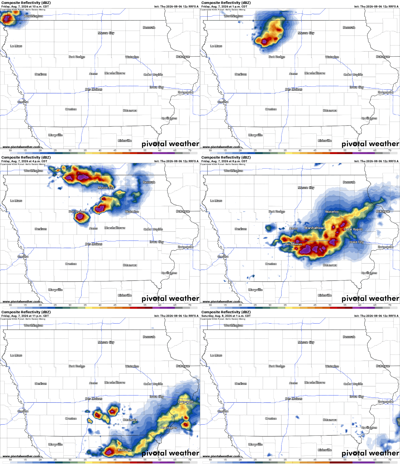
Scattered showers and thunderstorms will return to parts of Iowa on Friday as a disturbance moves southeast through the region. A few showers may be present during the morning, especially across northwest Iowa and areas near or east of Interstate 29. Storm coverage should increase during the afternoon and evening as temperatures rise and a weak front moves into the state. Rain is not expected to last all day, and many communities will experience several dry hours. The exact location of the first storms remains uncertain because development will depend on where the frontal boundary settles and how quickly the atmosphere recovers from morning clouds. Overall confidence is moderate that storms will affect parts of Iowa, but lower regarding the exact timing for individual communities.
The atmosphere will become increasingly unstable Friday afternoon, especially across central and eastern Iowa. Warmer air near the surface, cooler air above the ground and strengthening winds aloft may allow a few thunderstorms to organize. The greatest potential for storms currently appears to stretch from western and central Iowa into the northeast and eastern portions of the state. Southern Iowa may see fewer storms initially, but the boundary could shift enough to bring activity farther south during the evening. Anyone with outdoor plans Friday should monitor the weather radar because storms may develop quickly near the front. Friday’s weather will feel more humid than Thursday, with dew points climbing through the 60s and potentially approaching 70 degrees in western Iowa.
Strong to Severe Storms Are Possible Friday
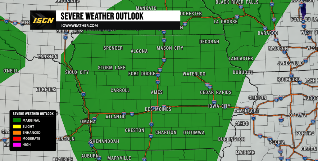
A few of Friday’s thunderstorms may become strong or severe, although widespread severe weather is not guaranteed. Wind shear, which describes how wind speed and direction change with height, will be strong enough to support organized storms. The atmosphere may also contain enough instability for storms to produce damaging wind gusts and hail. The greatest threat should occur during the late afternoon and evening, when daytime heating overlaps with the approaching boundary. Some storms may initially develop as individual cells before organizing into a larger line or thunderstorm complex. Confidence is moderate in at least an isolated severe weather risk, but storm coverage remains one of the main forecast uncertainties. Damaging straight-line winds appear to be the most widespread potential hazard across eastern Iowa. Farther west and north, any isolated storm that remains separate from surrounding activity could also produce large hail.
Locally Heavy Rain May Accompany Friday Night Storms
Thunderstorms may continue into Friday night as a stronger current of wind develops several thousand feet above the ground. This low-level jet will transport moisture into Iowa and may help storms persist after sunset. Any organized cluster of thunderstorms could produce periods of heavy rain, frequent lightning and strong wind gusts. The risk for flash flooding remains relatively low because storms are expected to keep moving, but localized flooding cannot be ruled out. Areas that receive repeated thunderstorms over the same location would face the greatest concern. Confidence is currently low regarding where the heaviest rain will fall because small shifts in the frontal boundary could substantially change the storm track.
Rainfall totals will vary significantly across the state. Some communities may receive little or no rain, while locations beneath a stronger thunderstorm complex could quickly collect more than an inch. The highest localized amounts could exceed two inches if multiple storms move over the same area. Urban streets, ditches and poorly drained low spots would be the first areas to experience standing water. Widespread river flooding is not currently expected, but river and stream levels will need to be monitored if several rounds of storms affect the same basin. Drivers should never attempt to cross a flooded roadway, especially at night when water depth is difficult to judge.
Warmer and More Humid Weather Arrives This Weekend
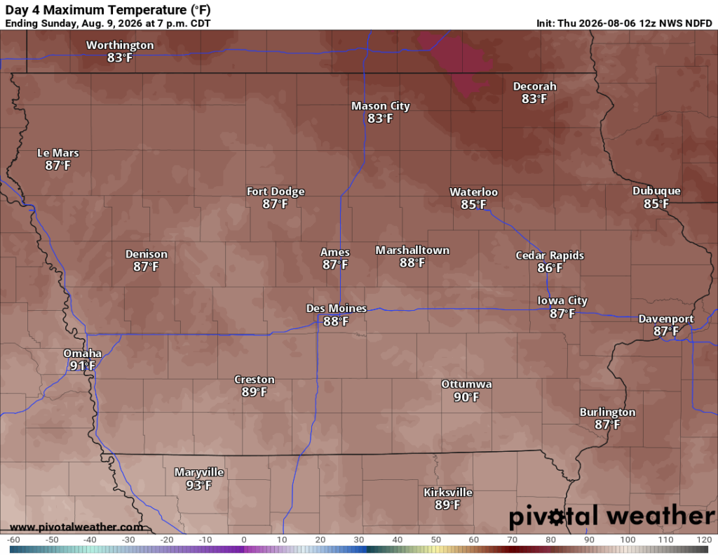
Temperatures and humidity will increase as southerly winds draw warmer air back into Iowa. Friday highs will range from the upper 70s to middle 80s, with the warmest temperatures likely across western Iowa. By Saturday and Sunday, many communities should reach the middle to upper 80s, while parts of western Iowa may approach 90 degrees. Dew points will climb into the upper 60s and lower 70s, making the air feel noticeably more humid. Cloud cover and the timing of thunderstorms will prevent temperatures from rising as much in areas that receive rain.
The heat index is not expected to reach dangerous levels across most of the state, but outdoor conditions will feel less comfortable than they did Thursday. Overnight temperatures will also become warmer, with lows generally remaining in the middle and upper 60s. By early next week, some locations may struggle to fall below 70 degrees overnight. People attending fairs, sporting events or other outdoor activities should plan for humidity and periodically take breaks. Drinking water will become increasingly important, especially during the afternoon. Storms may provide temporary cooling, but humidity will remain elevated after the rain ends.
Another Round of Storms Is Possible Saturday Night
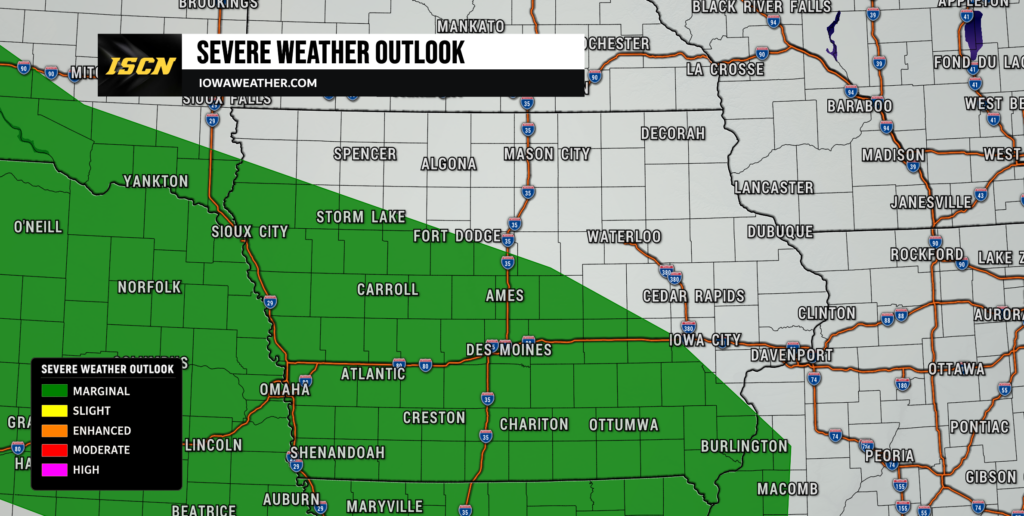
Saturday may include a substantial period of dry weather for parts of Iowa before another storm opportunity develops. A warm front is expected to lift northward across the region during the afternoon and evening. Thunderstorms may form near this boundary Saturday night as moisture increases and winds strengthen above the surface. Southern, western and central Iowa currently appear to have the greatest chance of seeing organized storms, although the risk area may shift as the forecast becomes clearer. Storms may then spread east or southeast overnight into Sunday morning.
Severe weather may again be possible Saturday night because the atmosphere could quickly recover after Friday’s storms. Damaging winds and large hail would be the primary concerns with any organized thunderstorm complex. A localized tornado threat may develop near the warm front if surface winds become favorably positioned, but this possibility remains highly dependent on the boundary’s exact location. Heavy rain may become a greater concern if storms repeatedly track over areas that received substantial rainfall Friday.
Periodic Storm Chances Continue Into Next Week
The active pattern will likely continue from Sunday through at least the middle of next week. Iowa will remain positioned near a boundary separating warmer, more humid air to the south from somewhat cooler air to the north. Several disturbances will travel along that boundary and create additional opportunities for showers and thunderstorms. Rain is unlikely to occur continuously, and many locations will experience long dry periods between storm rounds. Predicting exact timing more than a day or two in advance will be difficult because each thunderstorm complex may push the boundary into a new location.
Northern Iowa could see a renewed severe weather risk Sunday night or Monday as an area of low pressure passes near the Iowa-Minnesota border. Storms may become organized where warm, humid air meets stronger winds close to the low-pressure center. A cold front may then move southward and stall somewhere across Iowa or nearby states. Additional storms could develop along that stalled front Tuesday and Wednesday. Repeated rainfall may eventually create a more meaningful flooding concern, especially if the same counties are affected several times. It is too early to identify a specific flooding corridor, so forecast updates will be important throughout the weekend and early next week.
Stay with IowaWeather.com for the latest Iowa weather forecast, live radar updates and information on severe weather, heavy rain, fog and changing weekend conditions.