Iowa Weather Forecast: Colder Air Arrives Thursday, Chilly Weekend Ahead Before Next Week’s Warm-Up
A noticeable change in the Iowa weather forecast is underway Thursday, November 12, as colder air spreads across the state, bringing brisk northwest winds, increasing cloud cover, and the possibility of a few sprinkles or flurries. After a relatively mild stretch of November weather, temperatures will struggle to climb out of the 40s across much of Iowa, with some northern communities remaining in the upper 30s. The combination of colder temperatures and gusty winds will make Thursday feel considerably chillier, especially during the morning and early afternoon. While a few locations could see brief light precipitation, most Iowans can expect a largely dry day.
The colder weather will stick around through Friday and into the upcoming weekend as Canadian high pressure settles over the Midwest. Overnight temperatures will fall into the 20s across much of the state, with some northern and northwestern communities potentially dipping into the upper teens. Afternoon temperatures will remain below seasonal averages through the weekend, making coats and jackets a necessity for anyone spending time outdoors. The good news is that widespread rain, accumulating snow, and significant winter weather are not expected during this colder stretch.
There is also a warmer change on the horizon. A developing shift in the upper-level weather pattern should allow temperatures to gradually rebound beginning Sunday and continuing into next week. Highs could return to the 50s across much of Iowa, with some western and southwestern communities potentially approaching 60 degrees by the middle of the week. Rain chances may also return around Wednesday or Thursday, although confidence in the timing and coverage of that system remains limited.
Thursday’s Weather: Colder Temperatures and Gusty Northwest Winds
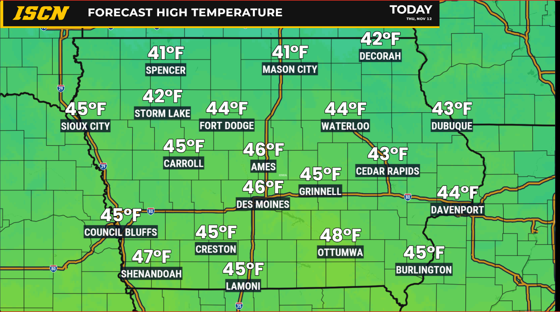
A cold front moving south through Iowa is bringing a fresh round of colder Canadian air into the state Thursday. Afternoon temperatures will generally reach the lower to middle 40s across central and eastern Iowa, with some southern locations climbing into the upper 40s. Northern and northwestern Iowa will experience the coldest conditions, where highs may remain in the upper 30s to lower 40s. These temperatures represent a drop of around 15 degrees compared to Wednesday in parts of central Iowa, making the change particularly noticeable. The cooler air will continue filtering southward throughout the day as winds remain out of the northwest and north.
Wind speeds will also contribute to the chilly conditions, particularly across central and eastern Iowa. Northwest wind gusts of 15 to 25 mph are expected during the morning, with a few isolated gusts reaching around 30 mph. The strongest winds should gradually ease during the afternoon and evening as high pressure begins building into the region. While these winds are not expected to cause significant problems, they will make outdoor activities feel less comfortable than the actual air temperature suggests. Anyone heading outside for an extended period should plan on wearing an extra layer, particularly during the morning hours when temperatures will be at their lowest.
Cloud cover will increase across much of Iowa as the day progresses, although occasional breaks of sunshine remain possible. Northern Iowa may experience more persistent low clouds, which could prevent temperatures from warming as much as forecast. Areas farther south could see a mixture of clouds and sunshine between passing disturbances. The overall weather pattern favors a chilly but relatively quiet Thursday, with no widespread hazardous weather expected. Confidence is high in the colder temperatures and breezy conditions, while the amount of sunshine will vary depending on how quickly the clouds develop and dissipate.
Temperatures Fall Below Freezing Thursday Night and Friday Morning
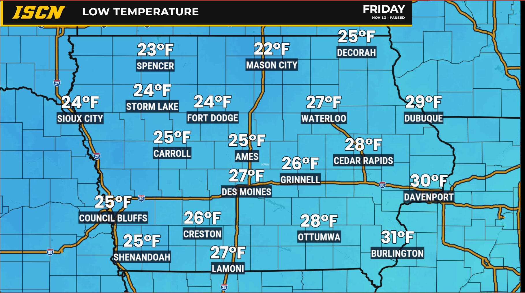
Temperatures will fall sharply Thursday night as colder air continues settling across Iowa and winds gradually diminish. Overnight lows are expected to drop into the lower 20s across northern Iowa, while central and southern communities generally fall into the middle and upper 20s. Some locations in far northern and northwestern Iowa could approach the upper teens if skies clear sufficiently. For portions of southern Iowa, this may be the first time this season that temperatures have fallen below 30 degrees. The widespread subfreezing temperatures will be a reminder that Iowa is moving deeper into the colder portion of November.
A large area of high pressure moving south from Canada will play an important role in the overnight temperature drop. High pressure often brings lighter winds and fewer clouds, allowing heat that accumulated near the ground during the day to escape more efficiently after sunset. This process is known as radiational cooling, and it can produce particularly cold overnight temperatures when skies are clear and winds are light. If clouds remain more widespread than expected, temperatures could stay a few degrees warmer in some communities. Forecast confidence is high that most of Iowa will fall below freezing, although the exact overnight lows will depend partly on cloud cover.
Residents who still have outdoor plants, exposed hoses, or other temperature-sensitive items should prepare for a hard freeze in many areas. The colder conditions will also make for a brisk start to Friday morning, especially for students waiting at bus stops and anyone commuting before sunrise. Fortunately, lighter winds should prevent wind chills from becoming dramatically colder than the actual temperatures in most locations. The coldest readings will generally occur shortly before sunrise, followed by a slow temperature recovery during the morning. Even with some sunshine Friday, afternoon temperatures will remain on the chilly side.
Friday and Saturday: Chilly, Dry Weather Continues
Friday will bring another round of below-average temperatures as high pressure continues building across the Upper Midwest. Afternoon highs will generally reach the upper 30s to middle 40s across Iowa, with the coldest conditions favored across northern portions of the state. A mixture of clouds and sunshine is expected, although some communities could experience more cloud cover than others. Another weak disturbance will pass through the region, but the atmosphere should be too dry to support much precipitation. Most locations can expect a dry Friday, making it a relatively quiet day for travel and outdoor plans despite the chilly air.
Friday night into Saturday morning will bring another widespread freeze, with temperatures falling into the 20s across much of Iowa. Portions of northwestern Iowa could drop into the upper teens, particularly where skies clear and winds become light. Saturday afternoon temperatures will remain cool, generally ranging from the upper 30s in northern areas to the lower and middle 40s elsewhere. The combination of cold mornings and limited daytime warming will make Saturday feel more like late November than the milder weather experienced earlier in the month. Anyone attending outdoor events or working outside should prepare for temperatures that may remain in the 30s and 40s for much of the day.
Despite the colder conditions, the weekend weather forecast looks favorable for those hoping to avoid rain or snow. High pressure should keep most of Iowa dry, with no significant storm systems expected to cross the state through Saturday. Sunshine may become more common as the weather pattern stabilizes, although some passing clouds will remain possible. Winds should generally be less troublesome than Thursday, allowing outdoor conditions to feel somewhat more comfortable during the afternoon. Confidence is high in the dry weekend forecast and the continuation of below-normal temperatures.
Sunday Forecast: Dry Conditions and a Gradual Warm-Up
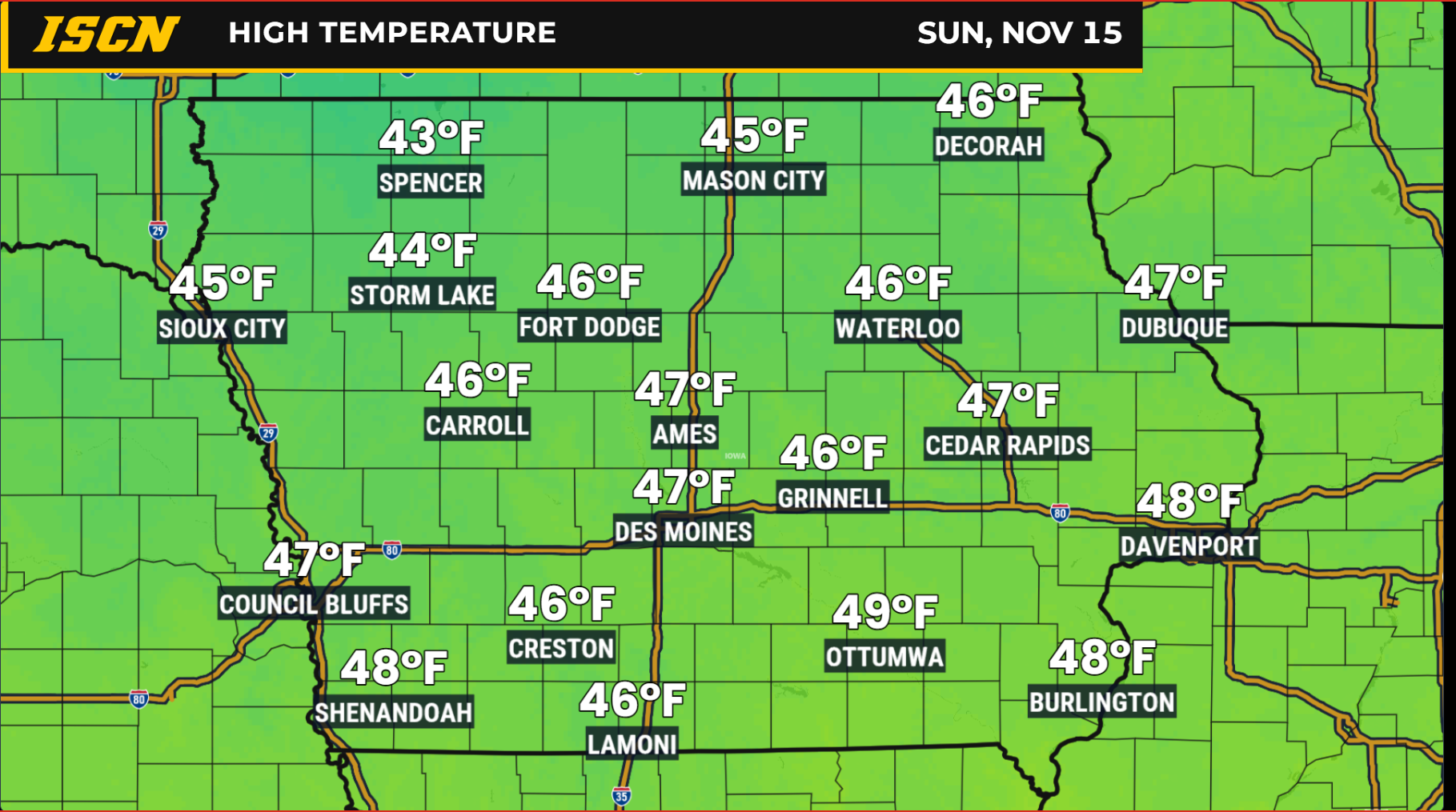
Sunday should mark the beginning of a gradual warming trend across Iowa as the large area of high pressure shifts farther east. Winds will begin turning more southerly or southwesterly, allowing slightly milder air to return to the region. Afternoon temperatures should climb into the middle and upper 40s across much of the state, although some northern communities may remain cooler. While these temperatures will still be somewhat below seasonal averages, the improvement will be noticeable compared to the colder conditions expected Friday and Saturday. Most locations should experience another dry day, providing a relatively favorable weather window for outdoor activities.
Earlier forecasts suggested that a passing storm system might bring a chance of precipitation to southwestern Iowa late in the weekend. However, more recent forecast guidance has shifted that system farther south, keeping the better opportunity for rain outside the state. This shift is connected to a strengthening area of high pressure and warmer air developing higher in the atmosphere, which is helping steer the disturbance away from Iowa. Confidence has increased that Sunday will remain dry across the state, although minor changes in cloud cover and temperatures are still possible.
The improving weather should continue into Sunday evening and Monday as the broader atmospheric pattern begins changing. Temperatures will not immediately return to the unusually mild levels experienced during previous warm spells, but the overall trend will be upward. Overnight temperatures will remain chilly, especially in areas where skies stay mostly clear. The lack of significant precipitation should also help keep road conditions favorable across Iowa through the end of the weekend. For residents planning travel or outdoor projects, Sunday appears to offer a better combination of temperatures and weather conditions than the preceding two days.
Next Week’s Iowa Weather: Temperatures Return to the 50s
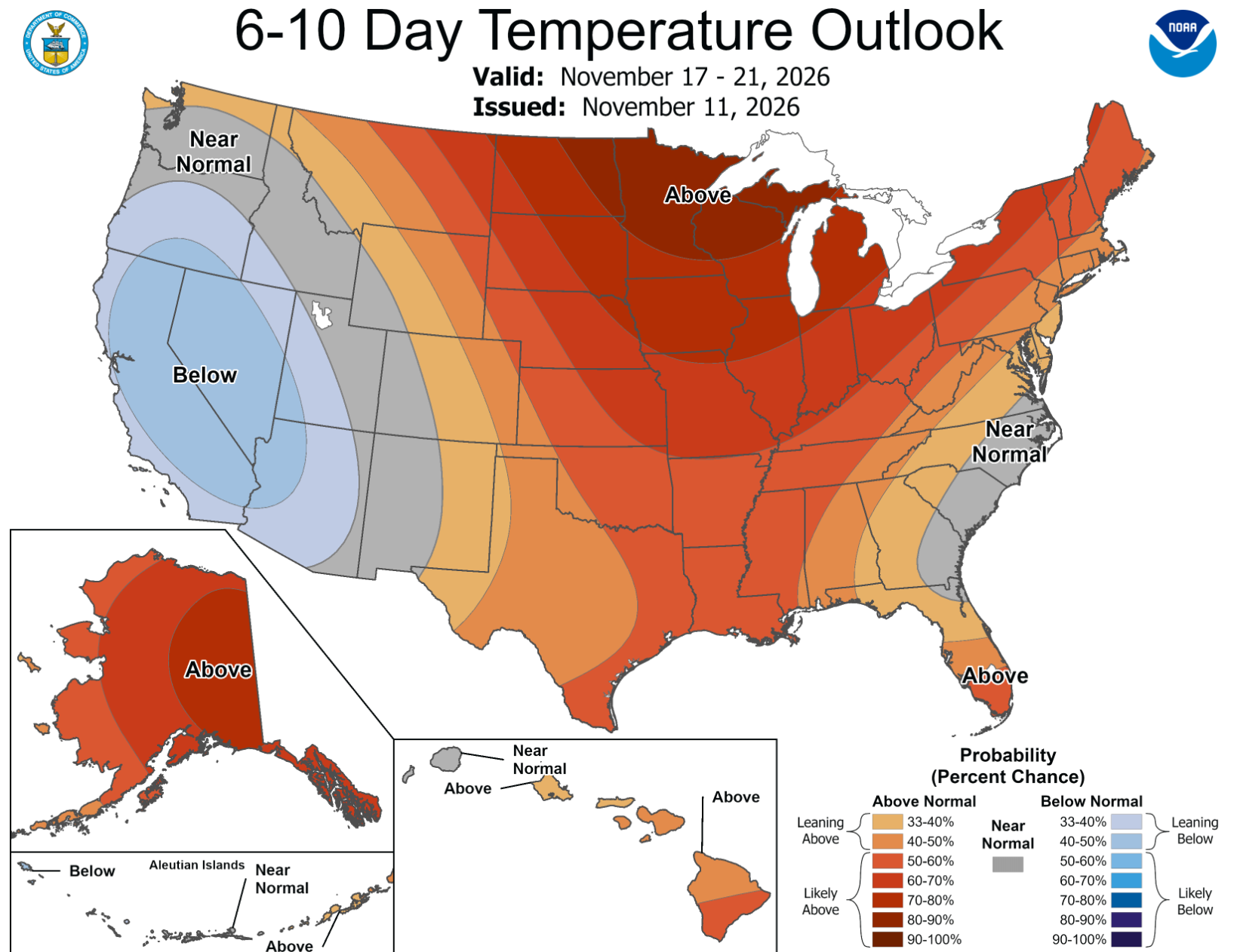
A larger change in the weather pattern will develop across the central United States early next week, bringing warmer temperatures back to Iowa. An upper-level ridge, which is an area of relatively warm air and higher atmospheric pressure, will expand eastward over the Plains and Midwest. This pattern will encourage milder air to move northward, gradually replacing the colder Canadian air that dominates the weekend. By Monday and Tuesday, afternoon temperatures should return to the 40s and 50s across Iowa, with additional warming possible by Wednesday. The warming trend should be most noticeable across western and southern portions of the state, where temperatures may climb into the upper 50s or even lower 60s by the middle of the week.
Central and eastern Iowa should also experience improving temperatures, with highs generally returning to the 50s as the week progresses. This would bring temperatures back toward or above seasonal averages following several days of below-normal readings. The warmer conditions are expected to develop without a significant increase in precipitation chances during the first part of the week. Monday and Tuesday currently look dry across most of Iowa, with a mixture of sunshine and passing clouds. Confidence is relatively high in the overall warming trend, although the exact temperatures will depend on the strength of the developing ridge and the amount of cloud cover.
Rain Chances May Return Around the Middle of Next Week
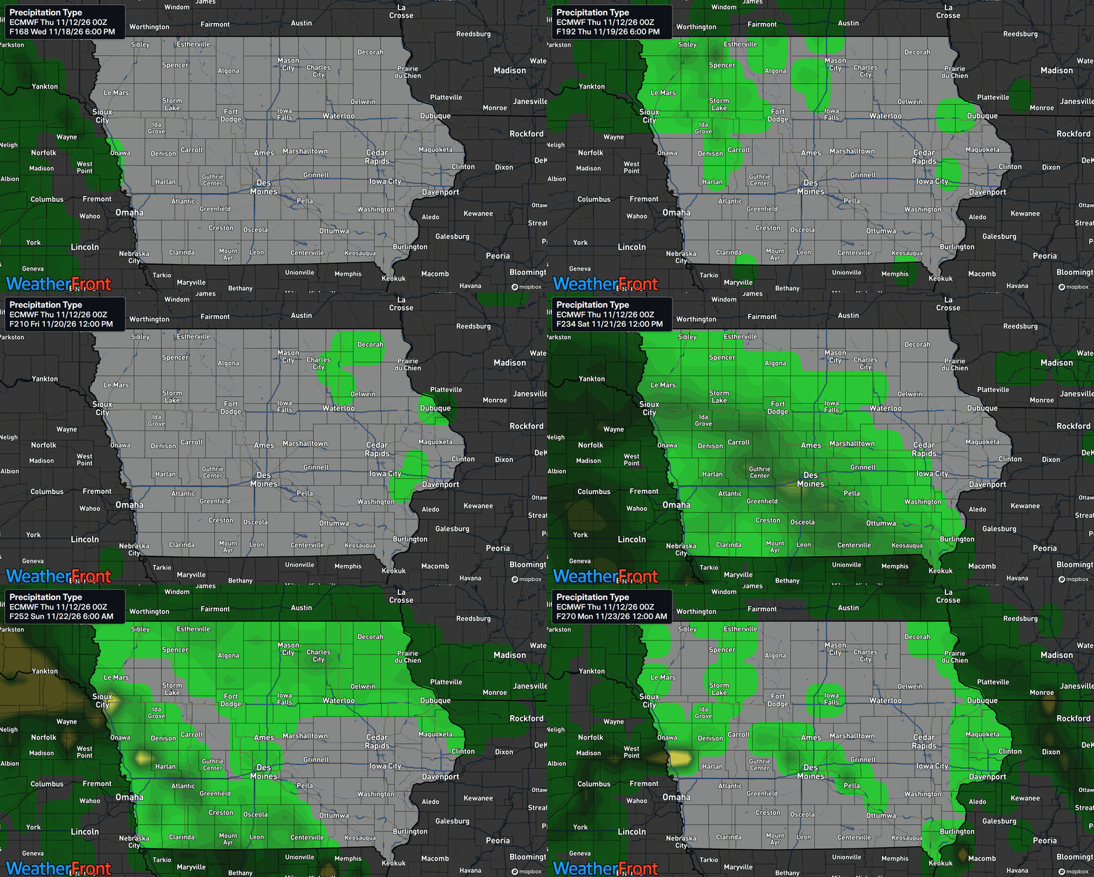
While the next several days look predominantly dry, forecast guidance suggests another weather system could approach the region around the middle of next week. A disturbance moving out of the Rocky Mountains may track toward the Northern Plains, potentially bringing renewed rain chances to parts of Iowa. Western and southwestern Iowa could see a chance of rain as early as Wednesday, with probabilities currently around 20% to 40% in portions of the Missouri River Valley. Farther north, some forecast guidance also indicates an increasing opportunity for light precipitation later in the week. However, the exact timing, track, and strength of this system remain uncertain.
The main challenge with this part of the forecast is that computer weather models do not yet agree on how quickly the disturbance will move eastward. Some solutions bring precipitation into the region Wednesday, while others delay the better opportunity until Thursday or later. The amount of available moisture will also determine whether the system produces meaningful rainfall or only scattered light showers. Current guidance does not provide strong support for widespread heavy precipitation across Iowa, and significant rainfall amounts are not indicated at this time. Confidence is moderate that another system could affect the broader region, but lower regarding the timing and precipitation coverage within Iowa.
There are also early signs that the larger weather pattern could become more active as the second half of November progresses. Some longer-range model scenarios show stronger storm systems developing across the Upper Midwest, potentially introducing additional rain or snow opportunities closer to Thanksgiving. However, these are early possibilities rather than reliable forecasts for specific locations or dates. It is far too soon to determine whether Iowa will experience a significant winter storm or whether the more impactful weather will remain elsewhere in the Midwest. The most useful approach is to watch how the pattern evolves over the next several days rather than focusing on individual long-range model solutions.
Stay connected with IowaWeather.com for the latest Iowa weather forecasts, temperature trends, live radar, and developing weather updates. As conditions change, the Iowa Storm Chasing Network will continue monitoring the forecast to help Iowans stay informed and prepared for whatever the weather brings.