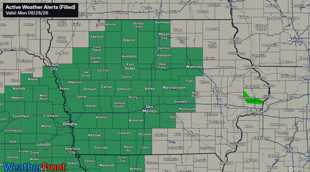
A significant stretch of wet weather is expected to unfold across Iowa from Tuesday into Thursday, and flooding is becoming the primary concern. Flood Watches now cover a large portion of the state, including much of central, western and northwestern Iowa. A widespread 2 to 4 inches of rain is expected within the main corridor, while locally higher amounts could exceed 5 inches depending on exactly where the heaviest bands repeatedly develop.
This will not necessarily be one continuous period of torrential rain. Instead, multiple rounds of showers and thunderstorms are expected to move across Iowa over roughly two days. That becomes important because soils are already wet from recent rainfall, meaning additional rain will have an easier time producing runoff into streets, low-lying areas, creeks, streams and eventually larger rivers.
The exact placement of the heaviest rain remains uncertain, but confidence is high that a prolonged period of rain will affect a large portion of Iowa. The Flood Watch is scheduled to begin Tuesday evening across much of the state and generally continue through Thursday evening or late Thursday night.
Flood Watch Covers a Large Portion of Iowa
Flood Watches stretch across much of central Iowa and into western and northwestern portions of the state. Cities within the watch include Des Moines, Ames, Fort Dodge, Mason City, Waterloo, Carroll, Marshalltown, Indianola, Council Bluffs, Sioux City, Spencer, Storm Lake and numerous surrounding communities. The watch means conditions are favorable for flooding, but it does not mean every community within the watch will experience flooding. Where flooding develops will depend heavily on how individual bands of heavy rain set up and whether they repeatedly move across the same locations. Residents in flood-prone areas should pay especially close attention to later forecast updates and any Flood or Flash Flood Warnings that may eventually be issued.
The widespread nature of the watch reflects both the amount of rain expected and the condition of the ground before the event begins. Much of Iowa has experienced substantial rainfall during recent weeks, leaving soils wetter than they would normally be heading into another multi-day rain event. Rivers and streams are also running higher in several areas, particularly across central Iowa. That reduces the amount of additional water the landscape can absorb before runoff increases. Even locations that avoid the very highest rainfall totals could therefore experience water problems if rain falls quickly enough.
2 to 4 Inches of Rain Expected, With Locally Higher Amounts
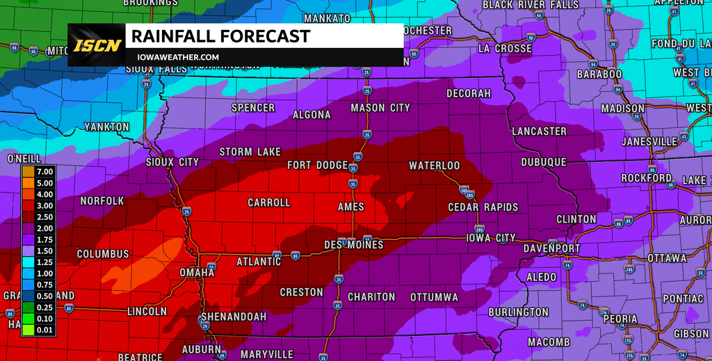
A broad swath of 2 to 4 inches of rain is expected to develop across portions of Iowa through Thursday, with the greatest amounts likely arranged in a southwest-to-northeast corridor. There is also potential for a much narrower band to receive 5 inches or more. Exactly where that corridor develops remains one of the biggest questions in the forecast. Some guidance places the highest amounts farther north into northwest and north-central Iowa, while other solutions shift the axis farther south. Current probabilities are particularly notable from around Omaha northeast toward Fort Dodge and Mason City, where the chance of receiving at least 2 inches of rain is very high.
This uncertainty means rainfall totals could vary considerably over relatively short distances. One community could receive a manageable amount of rain while another county or two away experiences repeated heavy downpours and substantially higher totals. Forecast confidence is much higher in the overall heavy-rain event than it is in exactly where the maximum rainfall occurs. That is common with systems involving repeated bands of showers and thunderstorms because relatively small changes in the position of a front or moisture corridor can shift the heaviest rain. The location of that corridor will become clearer as the event gets underway and shorter-range forecast guidance can better resolve individual rain bands.
When Will the Heavy Rain Begin in Iowa?
The first showers should begin reaching parts of northwest Iowa late Tuesday morning into Tuesday afternoon, but the more important period begins Tuesday night. Additional showers and thunderstorms are expected to develop from southwest Iowa northeastward as a strong stream of moisture moves into the state. Rain should become increasingly widespread by Wednesday, with periods of rain and embedded thunderstorms affecting a large part of Iowa. Wednesday into Wednesday night appears particularly important for the flooding threat as repeated rounds of rain move through the region.
Rain should gradually begin ending from northwest to southeast later Thursday, although the exact timing will vary across Iowa. Northwest Iowa could begin drying considerably earlier than southeastern portions of the state. Some rain may linger into Thursday night, particularly farther southeast, before the system finally pulls away. Because this is a prolonged event, flooding may not necessarily occur with the first round of rain; problems could increase as additional rounds fall onto progressively wetter ground.
Why Could This Rain Produce Flooding?
An unusually large amount of atmospheric moisture will be available to this storm system. Moisture associated with a tropical system over the eastern Pacific will become incorporated into a larger storm moving out of the southwestern United States, while another stream of moisture moves north from the Gulf. That combination will bring an exceptionally moist air mass into Iowa for late September and early October. Atmospheric moisture levels could approach or exceed values normally seen during the summer, allowing showers and thunderstorms to produce rain very efficiently.
The atmosphere will also support relatively deep layers of warm cloud, which favors the production of large quantities of rain rather than more inefficient precipitation processes. At the same time, a strong flow of air just above the surface will continually transport additional moisture into the region. The concern grows if rain repeatedly develops along the same southwest-to-northeast corridor. This process, sometimes called training, can produce much higher rainfall totals than surrounding areas when multiple rain bands pass over the same locations.
Stay with IowaWeather.com for the latest Iowa weather forecast, rainfall updates and flooding information as this multi-day rain event moves across the state.