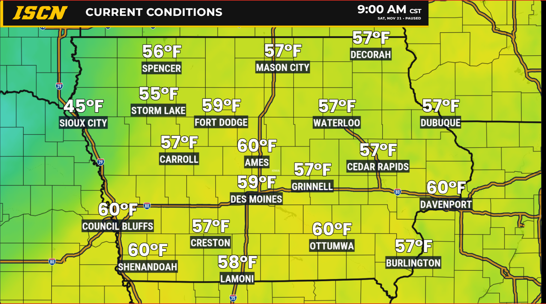
Iowa is in for quite a weather turnaround this weekend as unusually warm November temperatures give way to widespread rainfall, a few thunderstorms, and a significant drop in temperatures. Some areas of eastern Iowa could approach record highs Saturday afternoon before a cold front sweeps across the state, bringing a return to more typical late-November weather.
The transition will not happen everywhere at once. Northwestern Iowa is already experiencing the arrival of colder air, while southern and eastern portions of the state will enjoy one more unusually warm day. By Sunday, the colder air will have spread across Iowa, setting the stage for a chilly but generally quiet Thanksgiving week.
Unusually Warm Saturday for Southern and Eastern Iowa
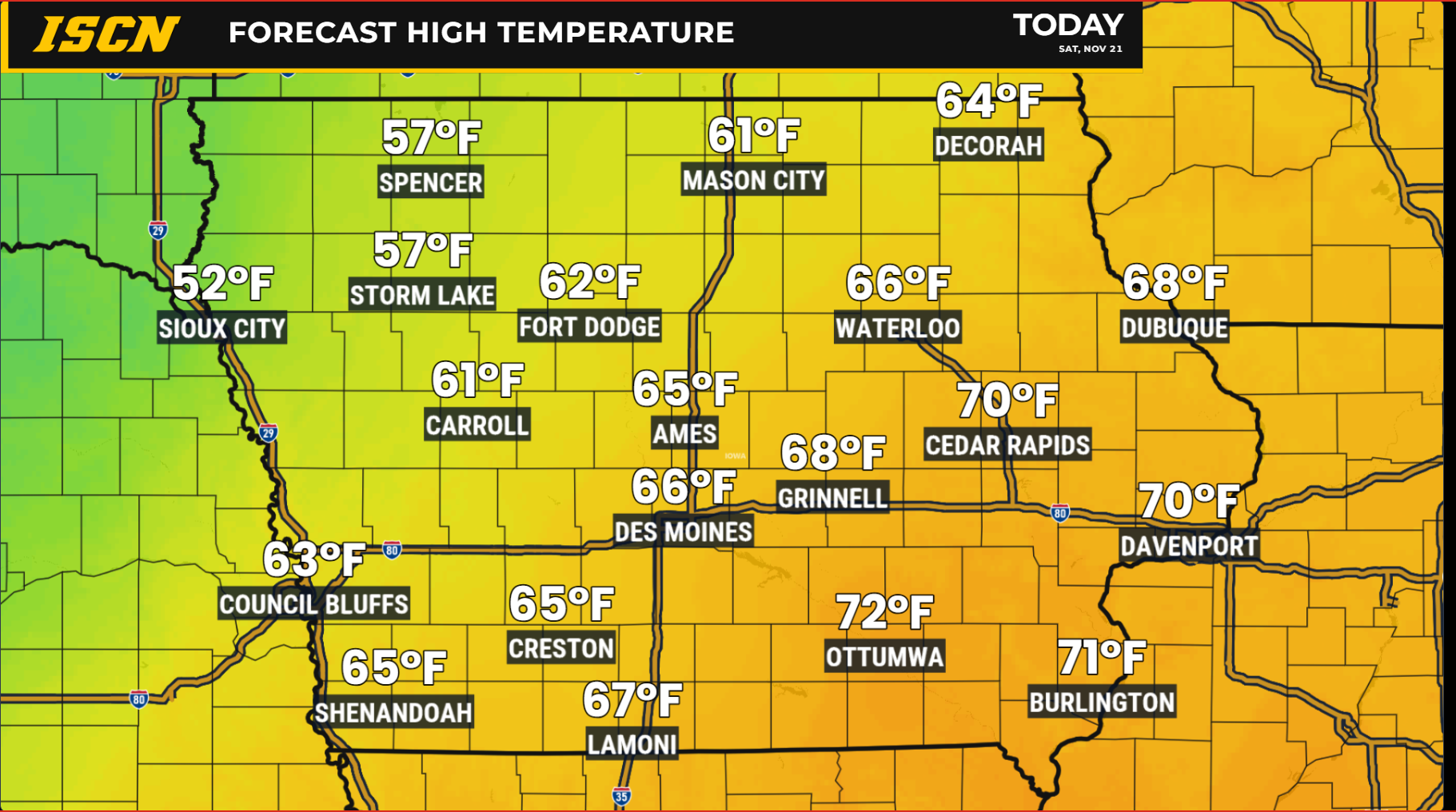
Temperatures will vary considerably across Iowa today as a strong cold front moves from northwest to southeast.
Ahead of the front, southern and eastern Iowa will experience temperatures well above normal for late November. Afternoon highs are expected to climb into the 60s, with some locations reaching the lower 70s. These readings are more typical of early fall than late November.
Eastern Iowa stands the best chance of approaching record-high temperatures, particularly around the Quad Cities and surrounding communities. Persistent southwesterly winds will continue transporting warm air into the region, helping temperatures rise despite some passing high clouds.
Farther northwest, the story will be quite different. The cold front has already moved through portions of northwestern Iowa, allowing temperatures to level off or fall during the day. Some locations in this part of the state may have already experienced their warmest temperatures during the early morning hours.
This sharp contrast will make for a particularly noticeable temperature difference between northwestern and southeastern Iowa throughout Saturday.
Showers and Thunderstorms Increase Through Saturday Night
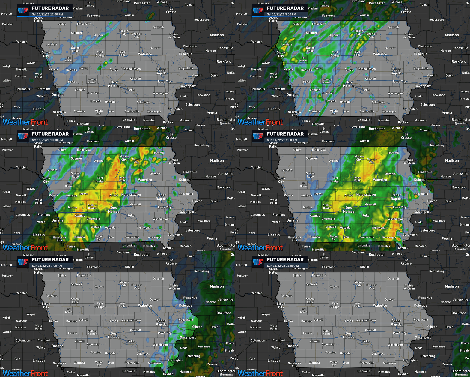
The approaching cold front will also bring increasing chances for rain across Iowa, although the timing will depend heavily on location.
Scattered showers and isolated thunderstorms developed early Saturday morning across portions of western and central Iowa. Additional rainfall is expected to develop during the afternoon as the frontal boundary advances eastward.
A few thunderstorms may develop within the rain, but atmospheric instability is limited. Any thunderstorms are expected to be relatively weak, with occasional lightning and brief periods of heavier rainfall being the primary concerns.
Farther east, much of eastern Iowa should remain dry through the daylight hours Saturday. Rain chances will increase during the evening, with the most widespread rainfall expected after midnight and continuing into Sunday morning.
The slower arrival of the cold front across eastern Iowa will allow the unusually warm conditions to persist longer before the transition to colder weather begins.
Rainfall Totals: Some Iowa Communities Could Receive Over an Inch
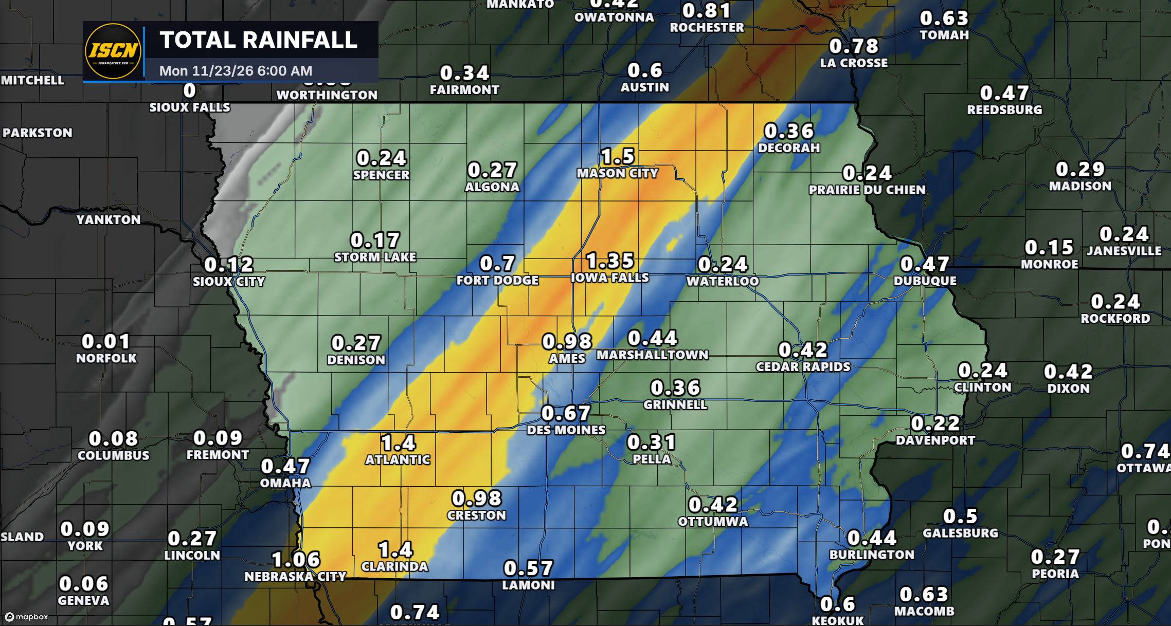
While showers and isolated thunderstorms will affect much of Iowa through the weekend, rainfall amounts will vary considerably depending on location. The latest forecast guidance suggests a relatively narrow corridor of heavier precipitation stretching from southwestern Iowa northeastward into north-central Iowa, where some communities could receive more than an inch of rain.
The greatest rainfall totals are currently projected along a corridor extending from near Clarinda and Atlantic northeastward through Ames, Iowa Falls, and Mason City. Within this area, widespread totals of 0.75 to 1.50 inches are possible, with locally higher amounts depending on where the most persistent bands of rain develop.
One of the more notable aspects of this forecast is how sharply rainfall totals could change over relatively short distances. This difference reflects the relatively narrow nature of the heaviest precipitation corridor. Locations directly beneath the most persistent rainfall bands could receive considerably more precipitation than communities just outside them.
Although the latest forecast favors southwestern through north-central Iowa for the highest totals, relatively small shifts in the placement of the rain bands could change which communities receive the greatest amounts.
Rainfall should gradually come to an end from west to east through Sunday, although some showers may linger longer across eastern Iowa.
Sunday Brings a Dramatic Change in Temperatures
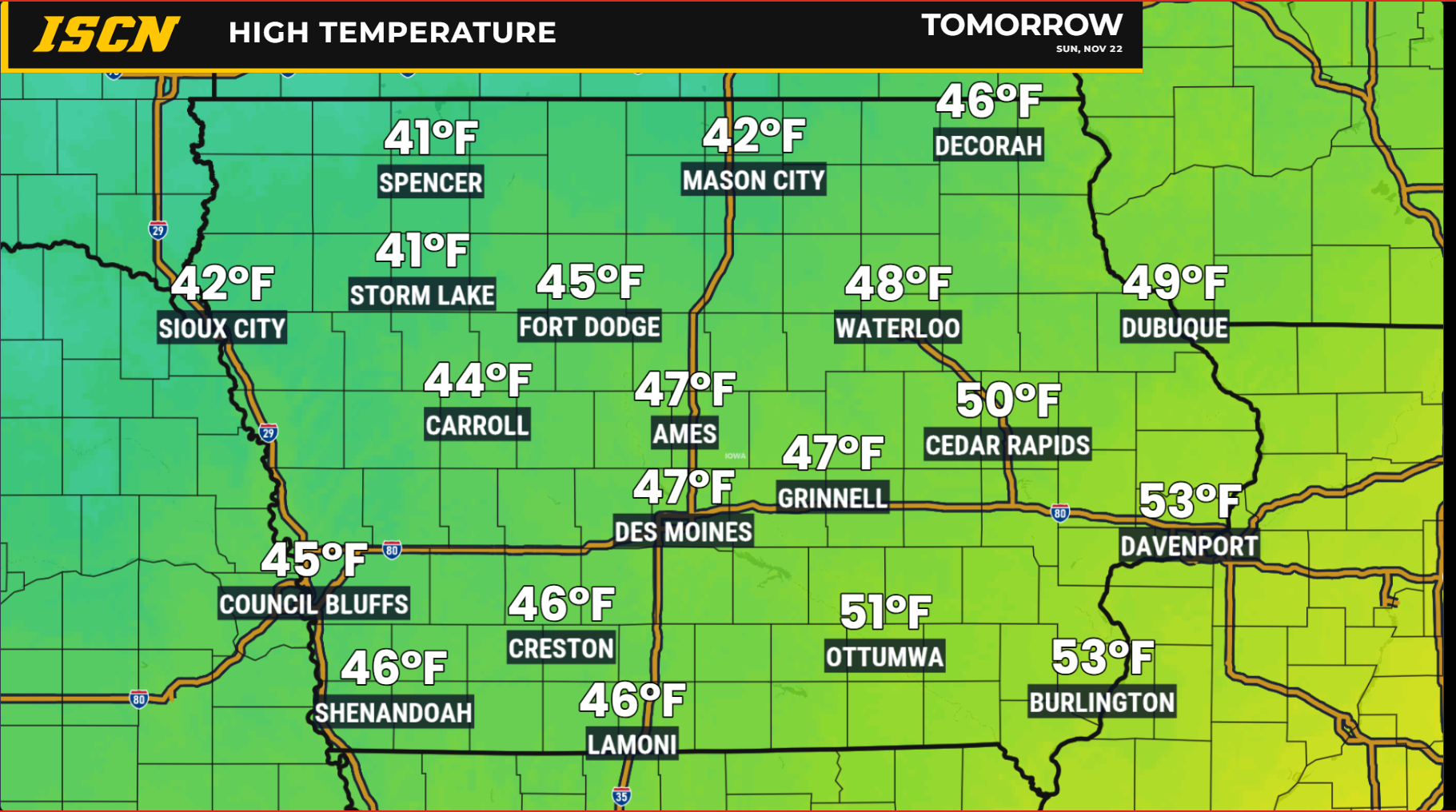
The unusually warm conditions will quickly disappear behind the cold front, with Sunday featuring a much more familiar late-November feel.
Across western and central Iowa, temperatures will generally reach the 40s, with some locations approaching 50 degrees. Sunshine should return to many areas as the rain exits.
Eastern Iowa will experience a more complicated temperature forecast. Some communities near the Mississippi River could begin Sunday morning with temperatures in the middle to upper 50s before colder air arrives. Temperatures may then fall throughout the day as northwesterly winds increase.
Rain will also linger longer across eastern and northeastern Iowa, with showers continuing through Sunday morning and potentially into the early afternoon in the far east.
Northeastern Iowa will experience some of the most noticeable changes. Northwest wind gusts of 25 to 35 mph are possible Sunday, adding an extra chill to the falling temperatures. By Sunday night, temperatures across much of Iowa will fall into the 20s, with some northern and northwestern communities approaching the upper teens.
The contrast between Saturday’s warmth and Monday morning’s chill will be substantial, especially across northeastern Iowa, where apparent temperatures could fall by roughly 40 degrees over a 48-hour period.
Colder Weather Settles In for Thanksgiving Week
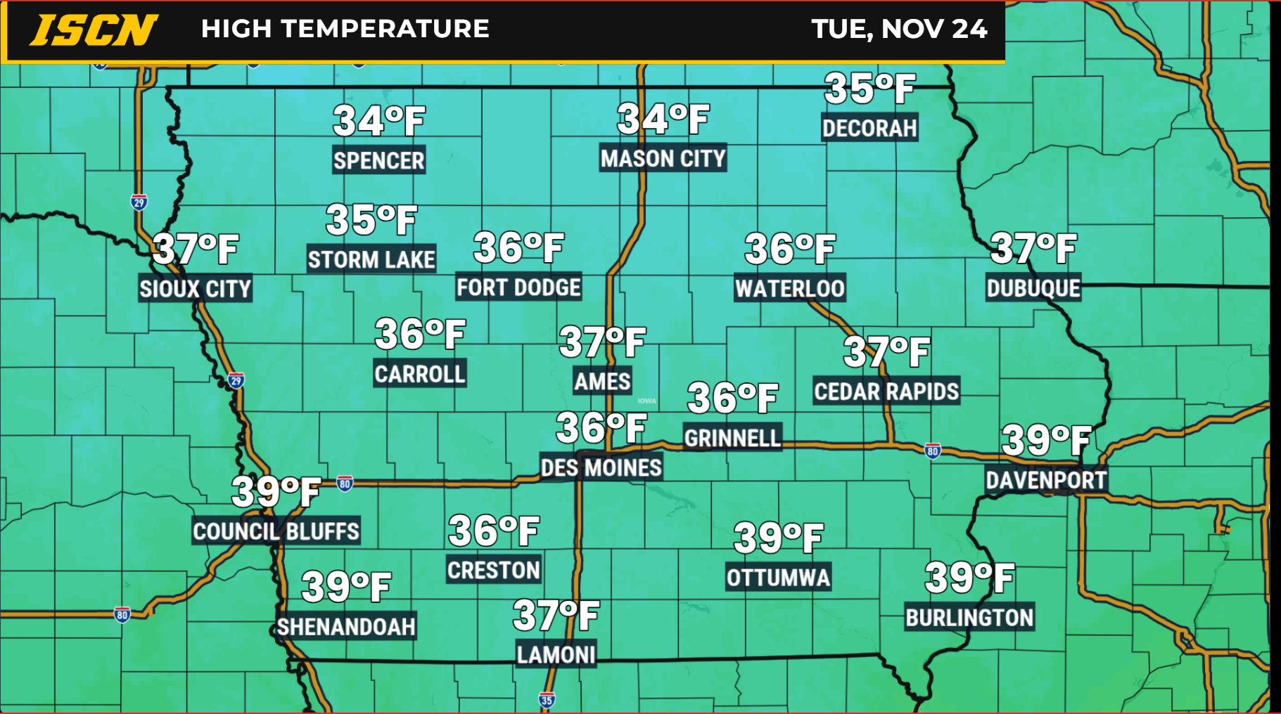
A broad area of Canadian high pressure will settle into the region early next week, bringing a stretch of colder, quieter weather. High temperatures Monday through Wednesday will generally range from the 30s to lower 40s, while overnight temperatures fall into the teens and 20s.
These readings will be much closer to what Iowa typically experiences during late November, although some locations may run slightly below seasonal averages. The colder air will be accompanied by relatively light winds for much of the week as high pressure dominates the region.
After the weekend rainfall exits, most of Iowa should experience several days of dry weather.
Thanksgiving Travel Outlook: Generally Favorable
Good news for Iowans planning to hit the road for Thanksgiving! The overall weather pattern is looking favorable for holiday travel, with no significant storm systems currently expected to impact the state during the upcoming week.
Following this weekend’s rainfall, quieter weather will settle across Iowa as high pressure builds into the region. Monday through Wednesday should feature predominantly dry conditions, with chilly temperatures but few weather-related travel concerns.
Thanksgiving Day, Thursday, November 26, is also looking favorable, with dry conditions expected across much of the state. Temperatures will remain on the chilly side, but the overall pattern should cooperate with holiday plans.
While some uncertainty remains in the forecast toward the end of the week, there are currently no strong indications of a major storm system that would cause widespread travel disruptions.
Overall, those traveling across Iowa for Thanksgiving can expect a relatively quiet stretch of late-November weather. As always, travelers should check the latest forecasts before heading out, especially for longer trips outside the state.
Stay ahead of changing weather conditions this Thanksgiving with IowaWeather.com and the Iowa Storm Chasing Network. For forecasts and weather alerts wherever you go, download the free ISCN Weather app on your smartphone. You can also tune in to our 24/7 Iowa weather channel for continuous weather coverage, forecasts, and updates to help you stay informed throughout the holiday season.