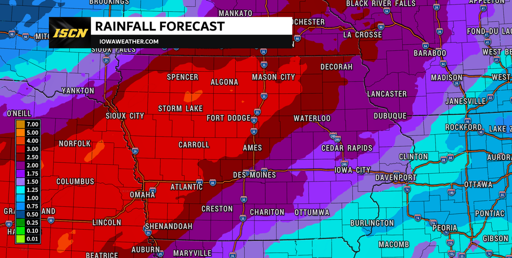
A quiet but cloudy Monday will give way to a much wetter weather pattern across Iowa as an unusually moisture-rich storm system approaches the state. Widespread rain is expected to develop from west to east beginning Tuesday, with multiple rounds of rain and embedded thunderstorms continuing into Wednesday and Thursday. Several inches of rain could fall before the system finally moves away.
The biggest concern is not severe weather but the amount of rain that could fall over an extended period. Current guidance supports widespread totals of at least 1 to 2 inches, while portions of Iowa could receive 2 to 4 inches or more. Exactly where that corridor of heaviest rain develops remains uncertain, but western and central Iowa currently have a strong signal for significant rainfall while the threat extends into eastern and northern Iowa.
Fog and Clouds Dominate Iowa Weather Today
Monday morning is starting with areas of fog and widespread low clouds across much of Iowa. Some of the thickest fog has developed across northern and northwestern portions of the state, where visibility can locally fall to around one mile or less. Northeast Iowa may also experience sudden reductions in visibility during the morning commute, so drivers should be prepared for rapidly changing conditions. Most of the fog should gradually improve between roughly 9 and 11 a.m., although stubborn low clouds may take considerably longer to clear.
The afternoon weather will depend heavily on location. Eastern and southeastern Iowa have the best opportunity to see breaks in the cloud cover, while central and western portions of the state are more likely to remain mostly cloudy to overcast. Temperatures will generally reach the upper 60s to lower 70s, with some middle 70s possible where more sunshine develops. Monday remains dry for most of Iowa, making it the final widespread dry day before the weather pattern changes.
Rain Returns to Iowa Tuesday
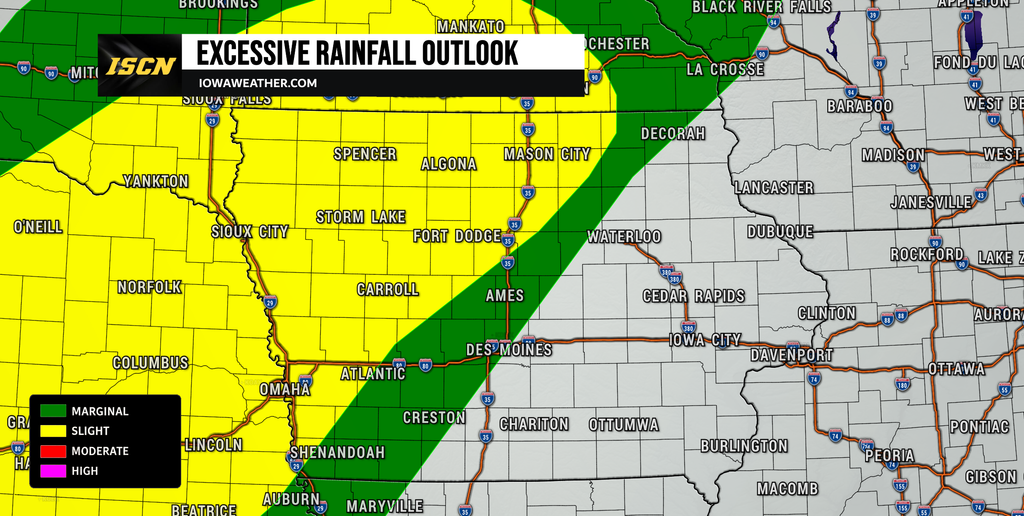
The rain forecast becomes much more active Tuesday as moisture rapidly increases across the Plains and Midwest. Showers should first become more widespread across western Iowa Tuesday morning before gradually expanding eastward through the day. Northwest Iowa may see rain arrive particularly early, while central Iowa is more likely to see rain chances increase later Tuesday and Tuesday night. Eastern Iowa should remain dry longer, with the more widespread rain potentially holding off until Tuesday night or Wednesday morning.
Rain will not necessarily fall continuously at every location once it begins. Instead, expect periods of showers and embedded thunderstorms with occasional breaks between heavier rounds. Severe thunderstorms are not expected to be the main concern because instability will be limited, reducing the atmosphere’s ability to produce strong or damaging storms. Even without severe thunderstorms, individual showers and storms could produce locally heavy rain because of the unusually high amount of moisture available.
Tropical Moisture Will Fuel the Multi-Day Rain Event
What makes this week’s Iowa weather pattern unusual is where some of the moisture is coming from. An upper-level storm system moving through the southwestern United States is interacting with tropical moisture associated with the remnants of Polo from the eastern Pacific. At the same time, strengthening southerly winds will transport additional moisture north from the Gulf and southern Plains. These moisture sources will combine as the storm system approaches Iowa.
Atmospheric moisture values are expected to climb well above what is typical for late September. In some areas, the amount of moisture available in the atmosphere will approach levels more commonly associated with much warmer environments farther south. This matters because thunderstorms do not need to become severe to produce very heavy rainfall. Deep layers of warm, moist air can make showers highly efficient at converting atmospheric moisture into rain, allowing significant amounts to accumulate during repeated rounds.
How Much Rain Could Iowa Receive?
Confidence is high that a widespread, meaningful rainfall event will affect Iowa, but confidence is lower regarding exactly where the heaviest rain will fall. Western and central Iowa currently have some of the strongest signals for totals exceeding 2 inches. Forecast probabilities indicate more than a 50% chance of receiving at least 2 inches during a 48-hour period across much of western and central Iowa, while portions of western Iowa have roughly a 20% to 30% chance of reaching 4 inches during that period.
Farther east, widespread totals of around 1 to 2 inches are possible Wednesday into Thursday, with locally higher amounts depending on how far east the primary rain axis progresses. Northeast Iowa also has a meaningful chance of significant rain, with guidance supporting a 50% to 70% probability of exceeding roughly 1.5 inches and a 20% to 30% probability of exceeding 3 inches in the broader region. These numbers should not be viewed as exact rainfall forecasts for individual communities. The placement of the heaviest band could still shift north, south, east, or west as the storm system evolves.
One important trend has been a gradual northward shift in the projected heavy-rain corridor. Some forecast guidance carries the greatest totals farther north toward northern Iowa, southern Minnesota, and Wisconsin, while other guidance maintains a heavier corridor farther south across Iowa. Small differences in the speed and interaction of several upper-level disturbances will determine where repeated rain develops. This uncertainty is why specific rainfall totals for individual Iowa communities should become more reliable as higher-resolution weather models come into range.
Flooding Concerns Increase Tuesday Through Thursday
Flooding will be the primary weather hazard to monitor this week. A broad corridor from the central Plains into the Upper Mississippi Valley is already highlighted for an elevated risk of excessive rainfall as deep tropical moisture moves north. Tuesday begins the period of concern across western Iowa, with the heavy-rain threat becoming more widespread Tuesday night into Wednesday. Additional rainfall Wednesday and potentially Thursday could become particularly important because it will fall after soils, streams, and rivers have already responded to earlier rain.
Flash flooding is possible if repeated showers and thunderstorms move across the same communities. This is sometimes called “training,” where multiple areas of heavy rain follow a similar path and cause rainfall totals to climb quickly. The exact location of any such corridor cannot be determined yet, making the flash flood threat more conditional than the overall heavy-rain forecast. However, recent rainfall has already caused rises on some rivers and streams, increasing concern that additional widespread rain could lead to river flooding.
People living near rivers, streams, and other flood-prone locations should monitor forecasts closely through the middle of the week. Several inches of rain falling over a large drainage basin can cause river levels to continue rising even after the rain has stopped. Urban and poor-drainage flooding could also develop during periods of particularly heavy rainfall. Flooding impacts will ultimately depend on exactly where the heaviest rain occurs and how quickly it falls.
Wednesday Could Be the Wettest Day for Much of Iowa
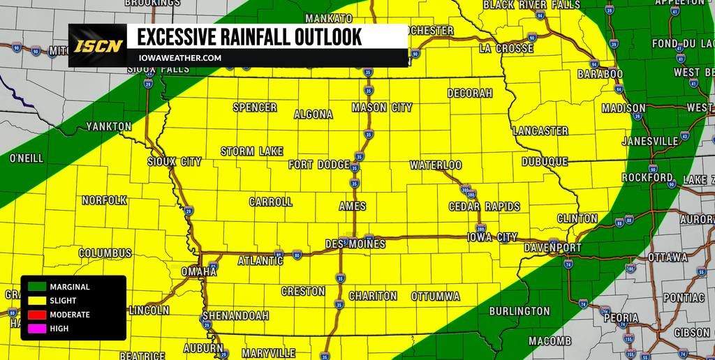
Wednesday currently appears to be one of the most active periods of the week as the moisture plume becomes firmly established across the region. Widespread showers and embedded thunderstorms are expected across much of Iowa, although the exact timing and intensity will vary throughout the day. Western and central Iowa could already have substantial rainfall totals by Wednesday morning, while eastern Iowa should see rain become increasingly widespread. Additional rounds could continue Wednesday afternoon and Wednesday night.
Travel conditions could deteriorate during heavier periods of rain. Reduced visibility, standing water and ponding on roads will become possible, especially in locations experiencing repeated downpours. Drivers should allow additional travel time and never attempt to cross a flooded roadway. Temperatures will also remain cooler because of extensive clouds and rain, with many locations struggling to warm much beyond the 60s or lower 70s.
The severe weather threat remains relatively low despite the possibility of thunderstorms. Weak atmospheric instability should make widespread damaging winds, large hail, or tornadoes unlikely with the current setup. The much greater concern is rainfall efficiency and the potential for storms to repeatedly produce heavy rain. That distinction will be important throughout the event: thunder may occur, but flooding rather than severe weather is the hazard receiving the greatest attention.
When Will the Rain End?
The storm system should gradually begin moving through the region Thursday, eventually pushing the deepest moisture east and south of Iowa. Exactly how quickly this occurs remains somewhat uncertain. A faster-moving system would allow rain to end sooner, while a slower or more separated upper-level low could keep rain over portions of Iowa longer Thursday. Current trends support improving conditions from west to east late Thursday into Friday.
Eastern Iowa may be among the last parts of the state to see the rain completely end. Rain chances there increase substantially Wednesday night into Thursday, meaning significant additional rainfall could occur even as western Iowa begins drying out. By the time the entire system departs, a large portion of the state should have received beneficial rain, although locally excessive amounts could create flooding problems. The final rainfall map will likely feature considerable variation depending on where repeated bands develop.
Cooler and Drier Weather Arrives Behind the Rain
A noticeable change should follow the storm system late this week. Cooler and substantially drier air will spread into Iowa behind a cold front, bringing an end to the humid and rainy conditions. High temperatures could remain mainly in the 60s across portions of the state Friday and into the weekend. Overnight temperatures may fall into the 40s in many locations, particularly across northern Iowa.
There is some uncertainty regarding exactly how cold the air mass will become. The colder forecast solutions suggest temperatures could become quite chilly across the Upper Midwest, potentially reaching the 30s north of Iowa and perhaps approaching that range in parts of the region. However, the current forecast does not support a widespread Iowa frost or freeze threat at this time. Confidence is higher in the overall transition toward cooler and drier weather than in specific overnight low temperatures several days from now.
Stay with IowaWeather.com for the latest Iowa weather updates, rainfall forecasts, weather radar information, and changes to the flooding threat as this significant rain event approaches.