After several days of thunderstorms and heavy rainfall across Iowa, the state is finally getting a much-needed break. Most of Sunday will feature drier air, lower humidity and comfortable August temperatures as high pressure settles across the region. A few lingering thunderstorms may affect far southern Iowa early, while an isolated shower or storm remains possible farther east later today as a cold front finishes moving through. Otherwise, the weather today will become increasingly pleasant with highs generally in the upper 70s to lower 80s.
The quiet stretch will continue through much of Monday, but it will not last long. Another active weather pattern develops Monday night into Tuesday as disturbances move southeast through strong northwest flow above the Midwest. Monday brings a conditional severe weather threat mainly near northwest Iowa, but Tuesday is the day that deserves considerably more attention statewide. The atmosphere could become favorable for organized severe thunderstorms capable of large hail and damaging winds, followed by the possibility of storms developing into a larger complex Tuesday evening and night. Heavy rainfall will also become a concern, especially given how wet parts of Iowa have been recently.
A Much-Needed Break From the Rain Sunday
Most Iowa residents asking, “Will it rain today?” will like the answer: for much of the state, probably not. Drier air is filtering south behind a cold front while high pressure builds into the Upper Midwest, allowing humidity levels to fall through the day. High temperatures should generally reach the upper 70s to lower 80s, which is comfortable for the middle of August. Northwest winds will help usher the drier air into the state, and sunshine should become more common as lingering clouds decrease. Western and northern Iowa have the highest confidence in remaining dry through the day, while precipitation chances linger somewhat longer farther south and east. Overall, Sunday should be one of the quieter weather days Iowa has experienced recently.
Thunderstorms moving through northern Missouri early Sunday could brush portions of far southern Iowa before deeper moisture retreats south. Another isolated shower or thunderstorm cannot completely be ruled out along the departing cold front, particularly across far eastern Iowa and areas closer to the Mississippi River. Any storm that develops could briefly produce heavy rain and lightning, but severe weather is not expected. Coverage should remain limited enough that most locations will stay dry. The front will continue southeast through the afternoon and evening, taking the remaining storm chances and muggy air with it. Skies should then continue clearing as Sunday evening progresses.
Monday Starts Quiet Before Storm Chances Return
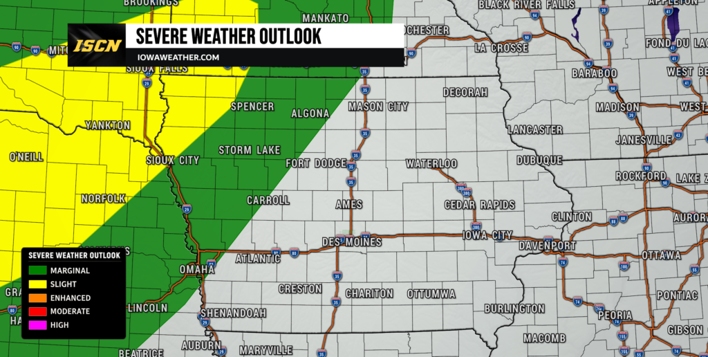
Monday should begin dry across most of Iowa as surface high pressure remains in control. Sunshine will be plentiful in many areas, with afternoon temperatures again generally climbing into the upper 70s and lower to middle 80s. Humidity should remain comfortable through at least the first portion of the day. By Monday afternoon, however, the weather pattern will begin changing as another cold front approaches from the northwest. Warmer and increasingly humid air will begin flowing north ahead of that boundary. Thunderstorm chances will consequently increase first across the northern and northwestern part of the state.
The greatest severe weather potential Monday afternoon and evening is expected to remain west and northwest of much of Iowa, especially across portions of Nebraska and the mid-Missouri Valley. However, northwest Iowa will be close enough to the developing storms that the threat bears watching. The environment near the approaching front could contain substantial instability combined with enough wind shear — the change in wind speed and direction with height — to organize thunderstorms. Large hail and damaging wind gusts would be the primary concerns with any severe storm that reaches or develops near northwest Iowa. Exactly how widespread storms become will depend partly on cloud cover and any earlier thunderstorms that could affect instability during the afternoon. Confidence is therefore lower regarding Monday’s storm coverage in Iowa than it is for the broader Tuesday threat.
Severe Weather Threat Increases Across Iowa Tuesday
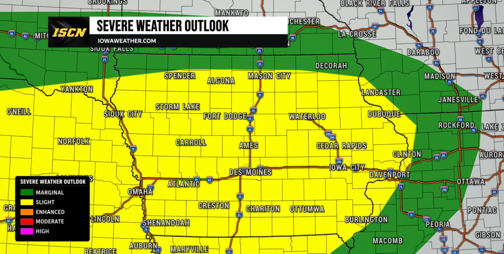
Tuesday has the potential to become the most active weather day of the early week. A cold front is expected to settle south into Iowa while a stronger disturbance approaches within northwest flow several thousand feet above the ground. At the same time, rich low-level moisture will return ahead of the boundary, allowing moderate to potentially strong atmospheric instability to develop during the afternoon. Wind shear of around 35 to more than 40 knots should be sufficient to support organized thunderstorms, including supercells during the initial stages of development. The combination places much of Iowa in a Slight Risk, Level 2 of 5, for severe thunderstorms Tuesday. While details will continue to change as Tuesday approaches, confidence is increasing that at least portions of Iowa will have an environment capable of supporting severe weather.
One of the biggest forecast questions involves exactly where the cold front will be positioned Tuesday afternoon. Current trends favor the boundary settling into Iowa, but thunderstorms Monday night and Tuesday morning could influence its eventual location. Areas along and south of that boundary would have access to the greatest moisture and instability, while locations north of it could experience a considerably lower severe weather threat. Morning clouds and thunderstorms could also reduce afternoon instability if they persist longer than expected. Conversely, several hours of sunshine south of the boundary could allow the atmosphere to become strongly unstable. Those details will determine where the most significant severe thunderstorm risk ultimately develops.
Large Hail and Damaging Winds Are the Main Severe Threats
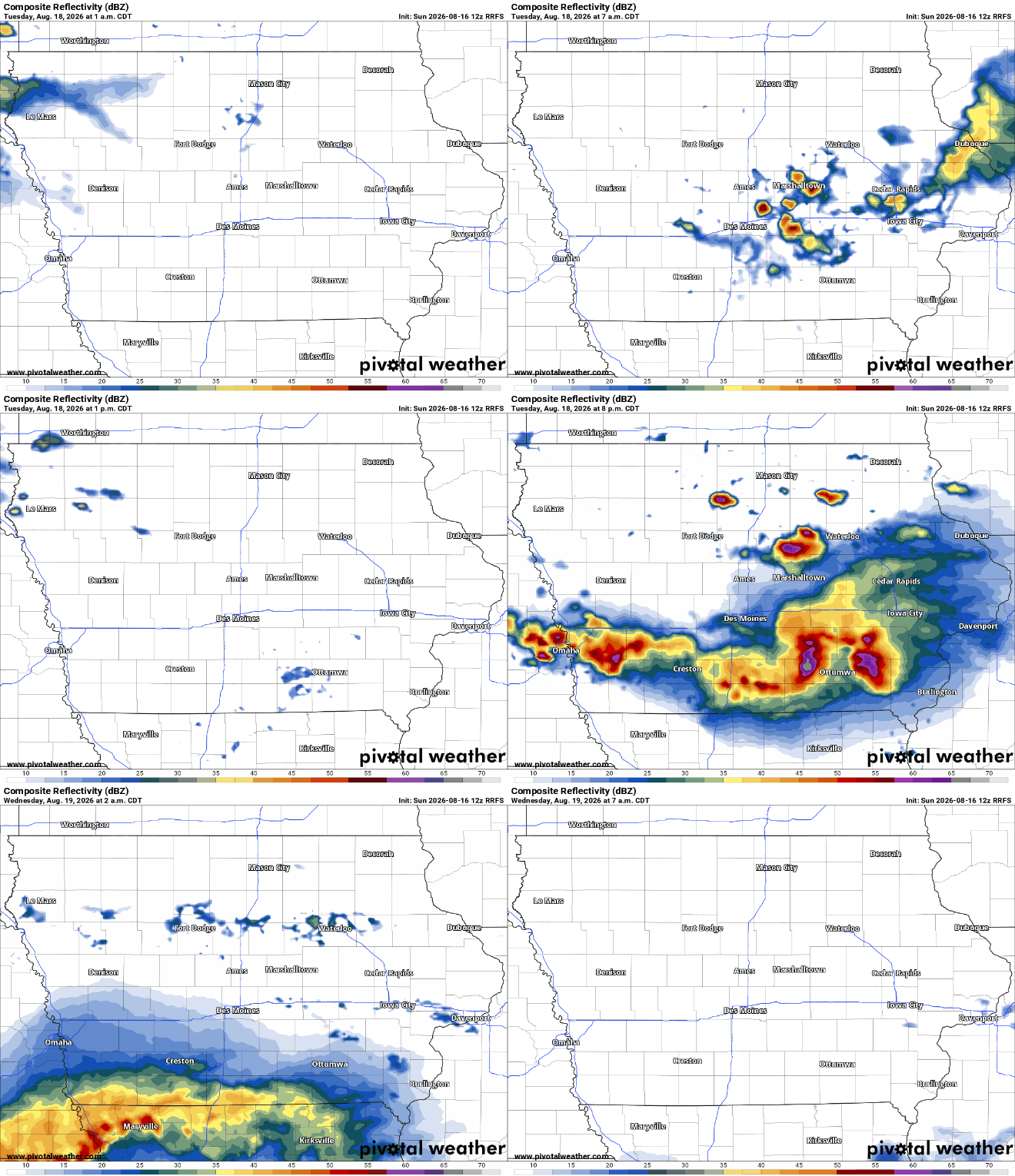
Large hail and damaging winds currently appear to be the primary severe weather hazards Tuesday afternoon and evening. Steep temperature changes through the middle levels of the atmosphere combined with strong instability could allow initially discrete storms to develop powerful updrafts capable of producing large hail. Wind profiles should also support organized storm structures rather than the weaker, short-lived thunderstorms Iowa sometimes experiences during the summer. As storms increase in number, they may begin merging into clusters and eventually organize into a larger thunderstorm complex. If that transition occurs, the threat would increasingly shift toward damaging straight-line winds during the evening and overnight hours. Frequent lightning and torrential rainfall would accompany the stronger storms as well.
The tornado threat is less clear at this stage and does not appear to be the primary concern based on the current forecast environment. However, the exact position of the surface boundary and how individual storms interact with it will need to be monitored as higher-resolution guidance becomes available. Storms that remain isolated for longer would generally have a better opportunity to take advantage of the available wind shear. If storms quickly merge into a line or large complex, damaging winds would likely become the more prominent concern. It is still too early to determine which Iowa communities have the greatest severe weather threat or exactly when storms will arrive. Those details should become substantially clearer over the next 24 to 36 hours.
When Will Thunderstorms Arrive Tuesday?
Some showers and thunderstorms could already be around portions of the region Tuesday morning as the front settles into Iowa. The more significant round of storms, however, is currently favored to develop during the afternoon and become more widespread into Tuesday evening. Initial thunderstorms may form near the frontal boundary before additional development occurs as a disturbance approaches from the northwest. Increasing winds just above the surface during the evening could then help storms consolidate into a larger mesoscale convective system, commonly called an MCS. Such systems can cover a large area and produce widespread heavy rain, frequent lightning and strong winds. The eventual track of that complex will be important in determining which areas experience the greatest impacts Tuesday night.
There is still meaningful uncertainty in the precise timing because Iowa will remain beneath northwest flow aloft. Small disturbances embedded within that flow can significantly change where and when thunderstorms develop, and those features can be difficult to resolve several days in advance. Monday’s thunderstorms may also alter the location of Tuesday’s front, adding another variable to the forecast. Current indications favor a broad afternoon-through-evening window for the greatest severe weather concern, with storms potentially continuing Tuesday night into early Wednesday. Residents should not focus on an exact arrival time yet. Updated weather radar and short-range model guidance Monday and Tuesday will provide a much clearer picture.
Heavy Rain and Flash Flooding Could Become a Concern Again
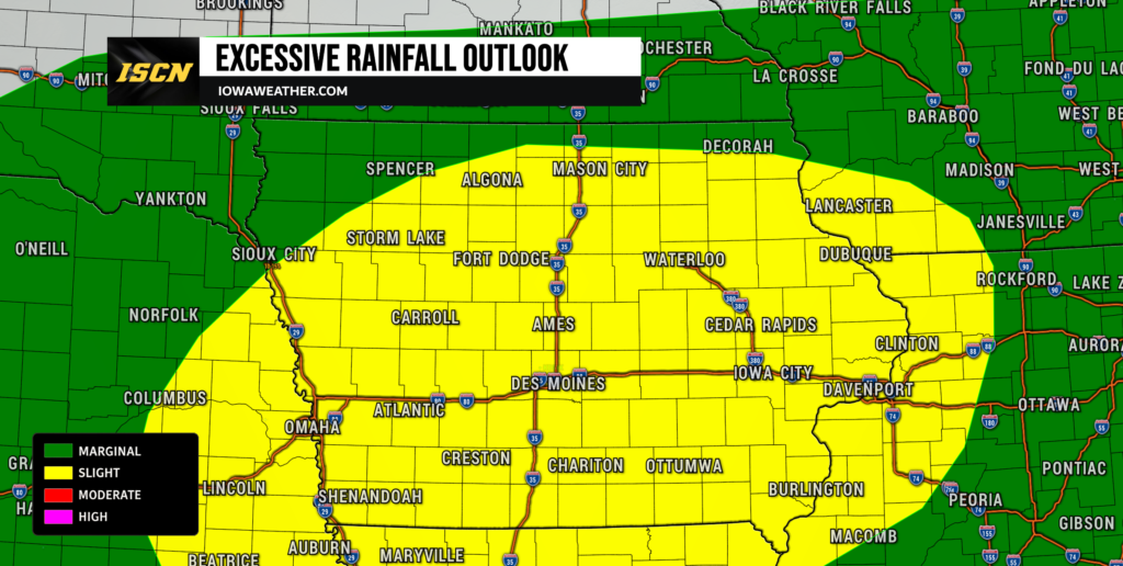
Severe weather will not be the only concern Tuesday. Iowa is also positioned within a Slight Risk for excessive rainfall, meaning scattered instances of flash flooding could develop where the heaviest thunderstorms occur. Atmospheric moisture is expected to increase substantially ahead of the front, with precipitable water values approaching 1.75 inches in portions of the region. Combined with strong instability, that moisture could support very high rainfall rates underneath thunderstorms. A stationary or slow-moving frontal boundary may initially provide a focus for repeated thunderstorm development before storms eventually begin moving southeast. The greatest heavy rain potential currently appears centered over Iowa and extends into neighboring portions of Nebraska, Kansas, Missouri and Illinois.
The eventual development of a faster-moving MCS may help prevent the flooding threat from becoming more widespread because the thunderstorm complex should eventually accelerate southeast. Before that happens, however, thunderstorms developing repeatedly near the boundary could produce locally significant rainfall totals over a relatively short period. That is especially important after the recent rounds of heavy rain across Iowa, where some locations have already experienced saturated soils and elevated waterways. It will not necessarily take as much additional rainfall to create localized problems in those areas. Confidence is fairly high that thunderstorms Tuesday will be capable of producing heavy rain, but confidence remains lower regarding exactly where the heaviest corridor sets up. Small shifts in the frontal boundary could move that axis north or south by a meaningful distance.
Comfortable August Temperatures Continue
Despite the return of thunderstorms, excessive heat is not expected to be a major concern during the next several days. Sunday’s temperatures will generally reach the upper 70s to lower 80s across Iowa, with Monday bringing similar readings or a modest warmup into the lower and middle 80s. Tuesday’s temperatures will depend more heavily on the location of the cold front, cloud cover and thunderstorms. Areas north of the boundary may remain in the upper 70s or lower 80s, while locations farther south could become somewhat warmer. These readings are close to normal or slightly below normal for the middle of August. Humidity will also be considerably more comfortable Sunday and Monday before increasing again ahead of Tuesday’s storms.
Another push of cooler air is expected behind the early-week system. High temperatures through the latter half of the week should generally remain in the 70s and 80s, with some areas running slightly below seasonal averages. Northwest flow will continue overhead, which prevents prolonged summer heat from becoming established across the state. Overnight temperatures should also remain relatively comfortable compared with the hot and humid stretches Iowa can experience in August. There will still be some day-to-day variation depending on clouds and passing disturbances. Overall, the temperature forecast favors seasonable to pleasantly cool conditions rather than another significant heat wave.
Keep checking IowaWeather.com for the latest Iowa weather forecast, radar updates and changes to Tuesday’s severe weather and heavy rain threat.